Property Record
2020 Sutter Pl, Davis, CA 95616
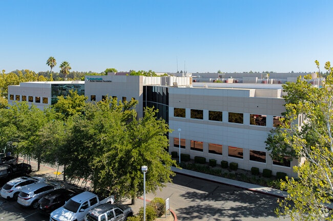

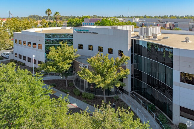
Property Detail
2020 Sutter Pl
Sacramento-Roseville-Folsom, CA
PM4249 PCL 2
036-681-001-000
Yolo
Hospitalpublic
California
PD
2
A Areas with a 1% annual chance of flooding and a 26% chance of flooding over the life of a 30-year mortgage.
0.79 AC
2024
Davis/Woodland
2025
Sacramento
010505
NEARBY LISTINGS FOR SALE OR LEASE
DEMOGRAPHICS near 2020 Sutter Pl
1 mile
3 mile
5 mile
2025 Total Population
18,186
67,348
85,006
2030 Population
18,782
69,320
87,300
Pop Growth 2025-2030
+ 3.28%
+ 2.93%
+ 2.70%
Average Age
36
33
34
2025 Total Households
6,941
22,992
29,446
HH Growth 2025-2030
+ 3.52%
+ 2.84%
+ 2.67%
Median Household Inc
$86,969
$77,907
$88,027
Avg Household Size
2.40
2.40
2.50
2025 Avg HH Vehicles
2.00
2.00
2.00
Median Home Value
$831,146
$798,166
$830,485
Median Year Built
1984
1980
1983
Nearby Places
Map Layers
Map Styles
 Street
 Aerial
Transit
 Traffic
 Biking
Places
Listings with unknown addresses are not visible on the map
- Restaurants
- Banks
- Shops
- Fitness
- Groceries
PUBLIC TRANSPORTATION
COMMUTER RAIL
Drive
Walk
Distance
9 min
3.0 mi
AIRPORT
Sacramento International
Drive
Walk
Distance
Sacramento International
28 min
19.1 mi
Freight Ports
Port of Stockton
Drive
Walk
Distance
Port of Stockton
75 min
60.9 mi
Nearby Properties
Address
Land Use
TOTAL SIZE
Lot Size
Zoning
Address
Land Use
TOTAL SIZE
Lot Size
Zoning
11.18 AC
P-D
Address
Land Use
TOTAL SIZE
Lot Size
Zoning
40,000 SF
16.56 AC
A1
Address
Land Use
TOTAL SIZE
Lot Size
Zoning
5.92 AC
P-D
Address
Land Use
TOTAL SIZE
Lot Size
Zoning
29,376 SF
0.14 AC
PD
Address
Land Use
TOTAL SIZE
Lot Size
Zoning
185,271 SF
1.01 AC
RHD
Address
Land Use
TOTAL SIZE
Lot Size
Zoning
0.20 AC
I
Address
Land Use
TOTAL SIZE
Lot Size
Zoning
209,988 SF
0.11 AC
PD
Address
Land Use
TOTAL SIZE
Lot Size
Zoning
168,279 SF
0.09 AC
R-M
Address
Land Use
TOTAL SIZE
Lot Size
Zoning
110,839 SF
0.26 AC
R3M
Address
Land Use
TOTAL SIZE
Lot Size
Zoning
174,228 SF
0.16 AC
PD
Address
Land Use
TOTAL SIZE
Lot Size
Zoning
4.40 AC
PD
Address
Land Use
TOTAL SIZE
Lot Size
Zoning
2.52 AC
I
Address
Land Use
TOTAL SIZE
Lot Size
Zoning
152,916 SF
0.17 AC
PD
Address
Land Use
TOTAL SIZE
Lot Size
Zoning
13,068 SF
8.25 AC
PD
Address
Land Use
TOTAL SIZE
Lot Size
Zoning
1.74 AC
CH
Address
Land Use
TOTAL SIZE
Lot Size
Zoning
1.93 AC
PD
Address
Land Use
TOTAL SIZE
Lot Size
Zoning
61,829 SF
1.31 AC
CC
Address
Land Use
TOTAL SIZE
Lot Size
Zoning
12,361 SF
0.59 AC
PD
Address
Land Use
TOTAL SIZE
Lot Size
Zoning
70,954 SF
3.73 AC
PD
Address
Land Use
TOTAL SIZE
Lot Size
Zoning
59,200 SF
2.34 AC
R3M
Address
Land Use
TOTAL SIZE
Lot Size
Zoning
158,000 SF
0.13 AC
PD
Address
Land Use
TOTAL SIZE
Lot Size
Zoning
61,624 SF
3.66 AC
PD
Address
Land Use
TOTAL SIZE
Lot Size
Zoning
94,720 SF
3.93 AC
R3M
Address
Land Use
TOTAL SIZE
Lot Size
Zoning
184,200 SF
0.13 AC
PD
Address
Land Use
TOTAL SIZE
Lot Size
Zoning
56,480 SF
2.15 AC
R3
Address
Land Use
TOTAL SIZE
Lot Size
Zoning
5.24 AC
I-R
Address
Land Use
TOTAL SIZE
Lot Size
Zoning
62,216 SF
2.49 AC
I
Address
Land Use
TOTAL SIZE
Lot Size
Zoning
13,243 SF
1.96 AC
A1
Address
Land Use
TOTAL SIZE
Lot Size
Zoning
0.11 AC
The World's #1 Commercial Real Estate Marketplace
Connect with us
© 2026 CoStar Group
The information above has been obtained from sources believed reliable. While we do not doubt its accuracy we have not verified it and make no guarantee, warranty or representation about it. It is your responsibility to independently confirm its accuracy and completeness. Any projections, opinions, assumptions, or estimates used are for example only and do not represent the current or future performance of the property. The value of this transaction to you depends on tax and other factors which should be evaluated by your tax, financial, and legal advisors. You and your advisors should conduct a careful, independent investigation of the property to determine to your satisfaction the suitability of the property for your needs.