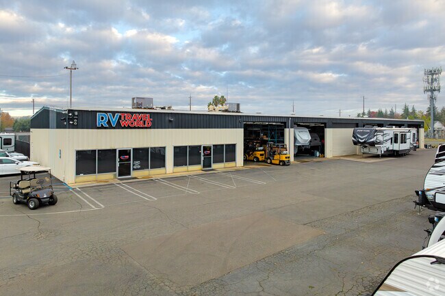
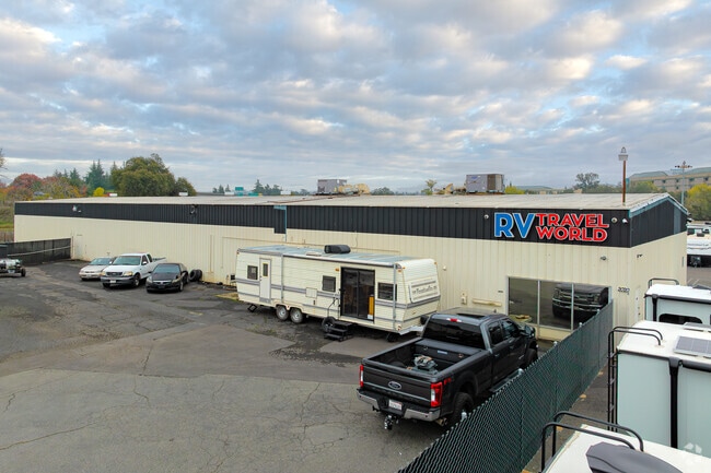
Property Record
2020 Taylor Rd, Roseville, CA 95678
Current Lease Availabilities
NEARBY LISTINGS FOR SALE OR LEASE
Property Detail
2020 Taylor Rd
015-162-004
Creekside Center
Vehiclerentalsvehiclesales
3.6 AC PAR 2 PMOR 24-14
X
Placer
06061C0944H
California
2024
3.60 AC
2025
Roseville/Rocklin
021003
Sacramento
23,040 SF
Sacramento--Roseville--Arden-Arcade, CA
DEMOGRAPHICS near 2020 Taylor Rd
1 Mile
3 Mile
5 Mile
2024 Total Population
8,223
102,083
231,982
2029 Population
8,778
109,122
246,806
Pop Growth 2024-2029
+ 6.75%
+ 6.90%
+ 6.39%
Average Age
39
40
40
2024 Total Households
3,413
39,243
85,298
HH Growth 2024-2029
+ 6.74%
+ 7.01%
+ 6.43%
Median Household Inc
$97,831
$98,177
$103,870
Avg Household Size
2.40
2.50
2.70
2024 Avg HH Vehicles
2.00
2.00
2.00
Median Home Value
$603,773
$623,856
$634,273
Median Year Built
1997
1991
1991
Nearby Places
Map Layers
Map Styles
 Street
 Aerial
- Restaurants
- Banks
- Shops
- Fitness
- Groceries
PUBLIC TRANSPORTATION
COMMUTER RAIL
Rocklin Amtrak Station (Capitol Corridor - Amtrak)
DRIVE
WALK
Distance
Rocklin Amtrak Station (Capitol Corridor - Amtrak)
4 min
1.9 mi
Roseville (California Zephyr - Amtrak, Capitol Corridor - Amtrak)
DRIVE
WALK
Distance
Roseville (California Zephyr - Amtrak, Capitol Corridor - Amtrak)
7 min
3.0 mi
AIRPORT
Sacramento International
DRIVE
WALK
Distance
Sacramento International
34 min
26.4 mi
Freight Ports
Port of Stockton
DRIVE
WALK
Distance
Port of Stockton
77 min
66.6 mi
Nearby Properties
Address
Land Use
TOTAL SIZE
Lot Size
Zoning
Address
Land Use
TOTAL SIZE
Lot Size
Zoning
1,444,630 SF
53.20 AC
Address
Land Use
TOTAL SIZE
Lot Size
Zoning
678,494 SF
15.80 AC
Address
Land Use
TOTAL SIZE
Lot Size
Zoning
350,573 SF
26.30 AC
Address
Land Use
TOTAL SIZE
Lot Size
Zoning
638,040 SF
38.70 AC
Address
Land Use
TOTAL SIZE
Lot Size
Zoning
277,602 SF
26.49 AC
Address
Land Use
TOTAL SIZE
Lot Size
Zoning
280,129 SF
14.90 AC
Address
Land Use
TOTAL SIZE
Lot Size
Zoning
325,462 SF
29.50 AC
Address
Land Use
TOTAL SIZE
Lot Size
Zoning
328,416 SF
17.80 AC
Address
Land Use
TOTAL SIZE
Lot Size
Zoning
105,730 SF
7.20 AC
Address
Land Use
TOTAL SIZE
Lot Size
Zoning
182,547 SF
10.19 AC
Address
Land Use
TOTAL SIZE
Lot Size
Zoning
174,840 SF
19.70 AC
Address
Land Use
TOTAL SIZE
Lot Size
Zoning
222,702 SF
10.57 AC
Address
Land Use
TOTAL SIZE
Lot Size
Zoning
223,623 SF
12.70 AC
Address
Land Use
TOTAL SIZE
Lot Size
Zoning
162,800 SF
11.70 AC
Address
Land Use
TOTAL SIZE
Lot Size
Zoning
132,784 SF
9.80 AC
Address
Land Use
TOTAL SIZE
Lot Size
Zoning
233,228 SF
12.10 AC
Address
Land Use
TOTAL SIZE
Lot Size
Zoning
28,798 SF
12.52 AC
Address
Land Use
TOTAL SIZE
Lot Size
Zoning
288,628 SF
11.90 AC
Address
Land Use
TOTAL SIZE
Lot Size
Zoning
143,809 SF
14.40 AC
Address
Land Use
TOTAL SIZE
Lot Size
Zoning
120,983 SF
17.60 AC
Address
Land Use
TOTAL SIZE
Lot Size
Zoning
191,820 SF
12.40 AC
Address
Land Use
TOTAL SIZE
Lot Size
Zoning
12,176 SF
22.70 AC
Address
Land Use
TOTAL SIZE
Lot Size
Zoning
154,696 SF
10.80 AC
Address
Land Use
TOTAL SIZE
Lot Size
Zoning
198,530 SF
11.50 AC
Address
Land Use
TOTAL SIZE
Lot Size
Zoning
121,000 SF
17.20 AC
Address
Land Use
TOTAL SIZE
Lot Size
Zoning
188,500 SF
20.30 AC
Address
Land Use
TOTAL SIZE
Lot Size
Zoning
314,360 SF
18.90 AC
Address
Land Use
TOTAL SIZE
Lot Size
Zoning
222,453 SF
27.60 AC
Address
Land Use
TOTAL SIZE
Lot Size
Zoning
82,661 SF
7.50 AC
Address
Land Use
TOTAL SIZE
Lot Size
Zoning
220,000 SF
10 AC
The World's #1 Commercial Real Estate Marketplace
Connect with us
© 2025 CoStar Group
The information above has been obtained from sources believed reliable. While we do not doubt its accuracy we have not verified it and make no guarantee, warranty or representation about it. It is your responsibility to independently confirm its accuracy and completeness. Any projections, opinions, assumptions, or estimates used are for example only and do not represent the current or future performance of the property. The value of this transaction to you depends on tax and other factors which should be evaluated by your tax, financial, and legal advisors. You and your advisors should conduct a careful, independent investigation of the property to determine to your satisfaction the suitability of the property for your needs.