Property Record
20200 Highway 160, Durango, CO 81303
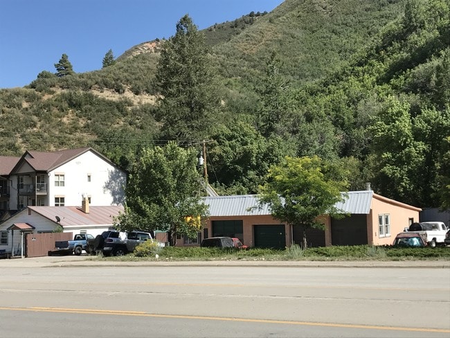

Property Detail
20200 Highway 160
R007133
STR: N2NW4S25&NE4NE4S26T35NR10W NMPM
Commercialnec
La Plata
C and X Area of minimal flood hazard, usually depicted on FIRMs as above the 500-year flood level.
Colorado
2024
0.81 AC
2025
Colorado Southwest Area
971100
Other Market Areas
2,759 SF
Durango, CO
NEARBY LISTINGS FOR SALE OR LEASE
DEMOGRAPHICS near 20200 Highway 160
1 mile
3 mile
5 mile
2025 Total Population
815
9,470
22,276
2030 Population
821
9,445
22,316
Pop Growth 2025-2030
+ 0.74%
(0.26%)
+ 0.18%
Average Age
39
40
39
2025 Total Households
373
4,169
9,327
HH Growth 2025-2030
+ 0.54%
(0.53%)
(0.16%)
Median Household Inc
$105,582
$89,798
$90,586
Avg Household Size
2.10
2.10
2.10
2025 Avg HH Vehicles
2.00
2.00
2.00
Median Home Value
$470,454
$721,326
$714,143
Median Year Built
2000
1975
1985
Nearby Places
Map Layers
Map Styles
 Street
 Aerial
Transit
 Traffic
 Biking
Places
Listings with unknown addresses are not visible on the map
- Restaurants
- Banks
- Shops
- Fitness
- Groceries
PUBLIC TRANSPORTATION
AIRPORT
Durango-La Plata County
Drive
Walk
Distance
Durango-La Plata County
27 min
16.2 mi
SALE & LEASE HISTORY
LISTING DATE
SALE/LEASE

Jul 25, 2017
For Sale
Nearby Properties
Address
Land Use
TOTAL SIZE
Lot Size
Zoning
Address
Land Use
TOTAL SIZE
Lot Size
Zoning
1,237,361 SF
230.69 AC
Address
Land Use
TOTAL SIZE
Lot Size
Zoning
277,165 SF
16.47 AC
Address
Land Use
TOTAL SIZE
Lot Size
Zoning
174,631 SF
32.10 AC
Address
Land Use
TOTAL SIZE
Lot Size
Zoning
153,242 SF
11.62 AC
Address
Land Use
TOTAL SIZE
Lot Size
Zoning
30,443 SF
0.65 AC
Address
Land Use
TOTAL SIZE
Lot Size
Zoning
112,681 SF
1.12 AC
Address
Land Use
TOTAL SIZE
Lot Size
Zoning
159,163 SF
5.50 AC
Address
Land Use
TOTAL SIZE
Lot Size
Zoning
87,592 SF
10.30 AC
Address
Land Use
TOTAL SIZE
Lot Size
Zoning
48,369 SF
0.63 AC
Address
Land Use
TOTAL SIZE
Lot Size
Zoning
45,824 SF
4.55 AC
Address
Land Use
TOTAL SIZE
Lot Size
Zoning
78,166 SF
6.73 AC
Address
Land Use
TOTAL SIZE
Lot Size
Zoning
51,923 SF
Address
Land Use
TOTAL SIZE
Lot Size
Zoning
45,340 SF
3.74 AC
Address
Land Use
TOTAL SIZE
Lot Size
Zoning
23,667 SF
1.91 AC
Address
Land Use
TOTAL SIZE
Lot Size
Zoning
51,561 SF
37.58 AC
Address
Land Use
TOTAL SIZE
Lot Size
Zoning
29,546 SF
4.14 AC
Address
Land Use
TOTAL SIZE
Lot Size
Zoning
23,503 SF
14.22 AC
Address
Land Use
TOTAL SIZE
Lot Size
Zoning
45,481 SF
5 AC
Address
Land Use
TOTAL SIZE
Lot Size
Zoning
72,094 SF
0.57 AC
Address
Land Use
TOTAL SIZE
Lot Size
Zoning
48,258 SF
3.30 AC
Address
Land Use
TOTAL SIZE
Lot Size
Zoning
49,001 SF
7.61 AC
Address
Land Use
TOTAL SIZE
Lot Size
Zoning
52,704 SF
1.73 AC
Address
Land Use
TOTAL SIZE
Lot Size
Zoning
45,080 SF
1.76 AC
Address
Land Use
TOTAL SIZE
Lot Size
Zoning
37,012 SF
2.06 AC
Address
Land Use
TOTAL SIZE
Lot Size
Zoning
62,356 SF
0.46 AC
Address
Land Use
TOTAL SIZE
Lot Size
Zoning
39,070 SF
Address
Land Use
TOTAL SIZE
Lot Size
Zoning
75,799 SF
3.08 AC
Address
Land Use
TOTAL SIZE
Lot Size
Zoning
7,459 SF
1.45 AC
Address
Land Use
TOTAL SIZE
Lot Size
Zoning
33,837 SF
5 AC
Address
Land Use
TOTAL SIZE
Lot Size
Zoning
28,778 SF
0.48 AC
The World's #1 Commercial Real Estate Marketplace
Connect with us
© 2026 CoStar Group
The information above has been obtained from sources believed reliable. While we do not doubt its accuracy we have not verified it and make no guarantee, warranty or representation about it. It is your responsibility to independently confirm its accuracy and completeness. Any projections, opinions, assumptions, or estimates used are for example only and do not represent the current or future performance of the property. The value of this transaction to you depends on tax and other factors which should be evaluated by your tax, financial, and legal advisors. You and your advisors should conduct a careful, independent investigation of the property to determine to your satisfaction the suitability of the property for your needs.