Property Record
20205 Se Highway 212, Damascus, OR 97089
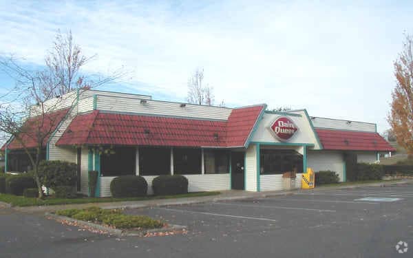

Property Detail
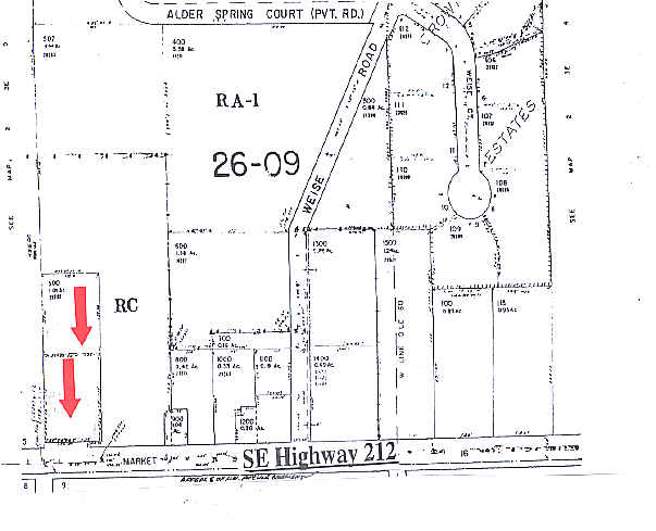
20205 Se Highway 212
00606712
SECTION 04 TOWNSHIP 2S RANGE 3E QUARTER CC TAX LOT 00500
Commercialbuilding
CLACKAMAS
RC
Oregon
B and X Area of moderate flood hazard, usually the area between the limits of the 100-year and 500-year floods.
500
2025
1.01 AC
2025
Clackamas/Milwaukie
023201
Portland
2,800 SF
Portland-Vancouver-Hillsboro, OR-WA
NEARBY LISTINGS FOR SALE OR LEASE
-
-
-
15861-15963 SE Happy Valley Town Center Dr
Happy Valley, OR 97086
Negotiable
1,346 - 3,364 SF
Retail
-
-
-
-
View all Damascus listings for sale on LoopNet.com
DEMOGRAPHICS near 20205 Se Highway 212
1 mile
3 mile
5 mile
2025 Total Population
2,108
27,605
82,365
2030 Population
2,124
28,080
82,803
Pop Growth 2025-2030
+ 0.76%
+ 1.72%
+ 0.53%
Average Age
44
40
41
2025 Total Households
702
9,195
27,700
HH Growth 2025-2030
+ 0.71%
+ 1.64%
+ 0.37%
Median Household Inc
$105,190
$109,244
$112,853
Avg Household Size
2.90
3.00
2.90
2025 Avg HH Vehicles
3.00
2.00
2.00
Median Home Value
$711,847
$699,202
$676,843
Median Year Built
1977
1999
1993
Nearby Places
Map Layers
Map Styles
 Street
 Aerial
Layers
 Traffic
 Biking
Places
Listings with unknown addresses are not visible on the map
- Restaurants
- Banks
- Shops
- Fitness
- Groceries
PUBLIC TRANSPORTATION
COMMUTER RAIL
Drive
Walk
Distance
17 min
9.7 mi
AIRPORT
Portland International
Drive
Walk
Distance
Portland International
31 min
20.1 mi
Freight Ports
Port of Portland
Drive
Walk
Distance
Port of Portland
34 min
19.6 mi
Nearby Properties
Address
Land Use
TOTAL SIZE
Lot Size
Zoning
Address
Land Use
TOTAL SIZE
Lot Size
Zoning
6.92 AC
MCC
Address
Land Use
TOTAL SIZE
Lot Size
Zoning
2,232 SF
15.74 AC
MUC
Address
Land Use
TOTAL SIZE
Lot Size
Zoning
12.06 AC
MCC
Address
Land Use
TOTAL SIZE
Lot Size
Zoning
9 AC
MUE
Address
Land Use
TOTAL SIZE
Lot Size
Zoning
8 AC
MURM1
Address
Land Use
TOTAL SIZE
Lot Size
Zoning
2,089 SF
4.30 AC
MURM2
Address
Land Use
TOTAL SIZE
Lot Size
Zoning
3,342 SF
9.34 AC
MUE
Address
Land Use
TOTAL SIZE
Lot Size
Zoning
4.83 AC
MCC
Address
Land Use
TOTAL SIZE
Lot Size
Zoning
5.66 AC
MCC
Address
Land Use
TOTAL SIZE
Lot Size
Zoning
1 AC
MURX
Address
Land Use
TOTAL SIZE
Lot Size
Zoning
5.52 AC
MURM1
Address
Land Use
TOTAL SIZE
Lot Size
Zoning
3.15 AC
MURM2
Address
Land Use
TOTAL SIZE
Lot Size
Zoning
Address
Land Use
TOTAL SIZE
Lot Size
Zoning
Address
Land Use
TOTAL SIZE
Lot Size
Zoning
Address
Land Use
TOTAL SIZE
Lot Size
Zoning
3,414 SF
6.16 AC
VA
Address
Land Use
TOTAL SIZE
Lot Size
Zoning
2,375 SF
3.32 AC
MUC
Address
Land Use
TOTAL SIZE
Lot Size
Zoning
3.32 AC
MCC
Address
Land Use
TOTAL SIZE
Lot Size
Zoning
2.05 AC
MUC
Address
Land Use
TOTAL SIZE
Lot Size
Zoning
Address
Land Use
TOTAL SIZE
Lot Size
Zoning
2,246 SF
10.52 AC
PMU
Address
Land Use
TOTAL SIZE
Lot Size
Zoning
5.82 AC
RC
Address
Land Use
TOTAL SIZE
Lot Size
Zoning
1.67 AC
MCC
Address
Land Use
TOTAL SIZE
Lot Size
Zoning
33.21 AC
RC-ME
Address
Land Use
TOTAL SIZE
Lot Size
Zoning
1.31 AC
MURM1
Address
Land Use
TOTAL SIZE
Lot Size
Zoning
1,598 SF
4.95 AC
IC
Address
Land Use
TOTAL SIZE
Lot Size
Zoning
1,152 SF
1.24 AC
RA1
Address
Land Use
TOTAL SIZE
Lot Size
Zoning
5.30 AC
RC
Address
Land Use
TOTAL SIZE
Lot Size
Zoning
2,270 SF
28.32 AC
FF10
Address
Land Use
TOTAL SIZE
Lot Size
Zoning
0.99 AC
VC
The World's #1 Commercial Real Estate Marketplace
Connect with us
© 2026 CoStar Group
The information above has been obtained from sources believed reliable. While we do not doubt its accuracy we have not verified it and make no guarantee, warranty or representation about it. It is your responsibility to independently confirm its accuracy and completeness. Any projections, opinions, assumptions, or estimates used are for example only and do not represent the current or future performance of the property. The value of this transaction to you depends on tax and other factors which should be evaluated by your tax, financial, and legal advisors. You and your advisors should conduct a careful, independent investigation of the property to determine to your satisfaction the suitability of the property for your needs.