Property Record
2021 N Kimball St, Mitchell, SD 57301

NEARBY LISTINGS FOR SALE OR LEASE
-
-
View all Mitchell listings for sale on LoopNet.com
Property Detail
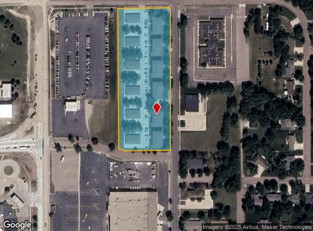
2021 N Kimball St
Mitchell, SD
Platted Various
15800-01500-204-20
LT G-3 EX W364' & EX S500' IN THE NW1/4 OF 15-103-60 PLATTED VARIOUS
Commercialnec
Davison
X
South Dakota
46035C0157D
(null
2025
3.97 AC
2025
South Dakota Area
962700
Other Market Areas
82,368 SF
DEMOGRAPHICS near 2021 N Kimball St
1 Mile
3 Mile
5 Mile
2024 Total Population
3,580
16,308
17,760
2029 Population
3,597
16,386
17,838
Pop Growth 2024-2029
+ 0.47%
+ 0.48%
+ 0.44%
Average Age
44
40
40
2024 Total Households
1,661
7,108
7,694
HH Growth 2024-2029
+ 0.54%
+ 0.49%
+ 0.44%
Median Household Inc
$42,400
$51,322
$51,609
Avg Household Size
2.00
2.20
2.20
2024 Avg HH Vehicles
2.00
2.00
2.00
Median Home Value
$157,374
$164,004
$166,887
Median Year Built
1973
1970
1970
Nearby Places
Map Layers
Map Styles
 Street
 Aerial
- Restaurants
- Banks
- Shops
- Fitness
- Groceries
SALE & LEASE HISTORY
LISTING DATE
SALE/LEASE

Mar 28, 2024
For Sale
Nearby Properties
Address
Land Use
TOTAL SIZE
Lot Size
Zoning
Address
Land Use
TOTAL SIZE
Lot Size
Zoning
169,700 SF
14.02 AC
22211
Address
Land Use
TOTAL SIZE
Lot Size
Zoning
78,565 SF
2.46 AC
121310
Address
Land Use
TOTAL SIZE
Lot Size
Zoning
77,139 SF
24.21 AC
32213
Address
Land Use
TOTAL SIZE
Lot Size
Zoning
106,098 SF
8.56 AC
120211
Address
Land Use
TOTAL SIZE
Lot Size
Zoning
84,712 SF
35.50 AC
111710
Address
Land Use
TOTAL SIZE
Lot Size
Zoning
256,818 SF
26.78 AC
32213
Address
Land Use
TOTAL SIZE
Lot Size
Zoning
4.11 AC
Address
Land Use
TOTAL SIZE
Lot Size
Zoning
147,940 SF
4.29 AC
Address
Land Use
TOTAL SIZE
Lot Size
Zoning
58,098 SF
3.19 AC
Address
Land Use
TOTAL SIZE
Lot Size
Zoning
59,862 SF
2.73 AC
Address
Land Use
TOTAL SIZE
Lot Size
Zoning
173,161 SF
37 AC
12711
Address
Land Use
TOTAL SIZE
Lot Size
Zoning
60,771 SF
2.61 AC
Address
Land Use
TOTAL SIZE
Lot Size
Zoning
80,578 SF
11.61 AC
20811
Address
Land Use
TOTAL SIZE
Lot Size
Zoning
189,974 SF
23.26 AC
12811
Address
Land Use
TOTAL SIZE
Lot Size
Zoning
49,600 SF
2.10 AC
Address
Land Use
TOTAL SIZE
Lot Size
Zoning
44,387 SF
2.08 AC
11911
Address
Land Use
TOTAL SIZE
Lot Size
Zoning
90,820 SF
8.68 AC
32812
Address
Land Use
TOTAL SIZE
Lot Size
Zoning
68,640 SF
4.70 AC
82710
Address
Land Use
TOTAL SIZE
Lot Size
Zoning
51,889 SF
1.72 AC
Address
Land Use
TOTAL SIZE
Lot Size
Zoning
45,825 SF
1.76 AC
21711
Address
Land Use
TOTAL SIZE
Lot Size
Zoning
55,482 SF
2.89 AC
21711
Address
Land Use
TOTAL SIZE
Lot Size
Zoning
75,800 SF
5.25 AC
21411
Address
Land Use
TOTAL SIZE
Lot Size
Zoning
54,617 SF
3.62 AC
21411
Address
Land Use
TOTAL SIZE
Lot Size
Zoning
77,272 SF
5.96 AC
Address
Land Use
TOTAL SIZE
Lot Size
Zoning
71,508 SF
6.31 AC
41212
Address
Land Use
TOTAL SIZE
Lot Size
Zoning
55,679 SF
4.43 AC
Address
Land Use
TOTAL SIZE
Lot Size
Zoning
51,376 SF
5 AC
13111
Address
Land Use
TOTAL SIZE
Lot Size
Zoning
51,639 SF
7.24 AC
110711
Address
Land Use
TOTAL SIZE
Lot Size
Zoning
52,500 SF
6.93 AC
The World's #1 Commercial Real Estate Marketplace
Connect with us
© 2025 CoStar Group
The information above has been obtained from sources believed reliable. While we do not doubt its accuracy we have not verified it and make no guarantee, warranty or representation about it. It is your responsibility to independently confirm its accuracy and completeness. Any projections, opinions, assumptions, or estimates used are for example only and do not represent the current or future performance of the property. The value of this transaction to you depends on tax and other factors which should be evaluated by your tax, financial, and legal advisors. You and your advisors should conduct a careful, independent investigation of the property to determine to your satisfaction the suitability of the property for your needs.