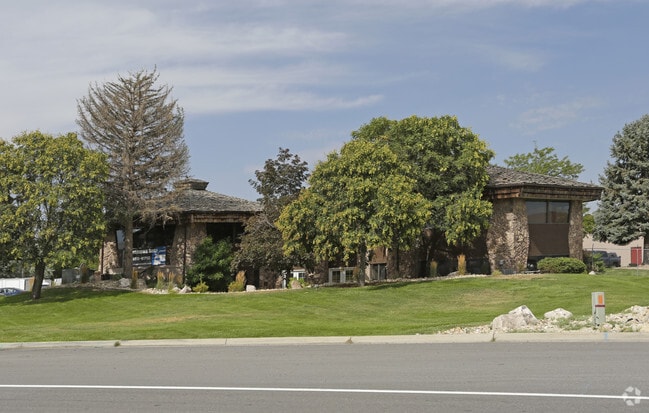
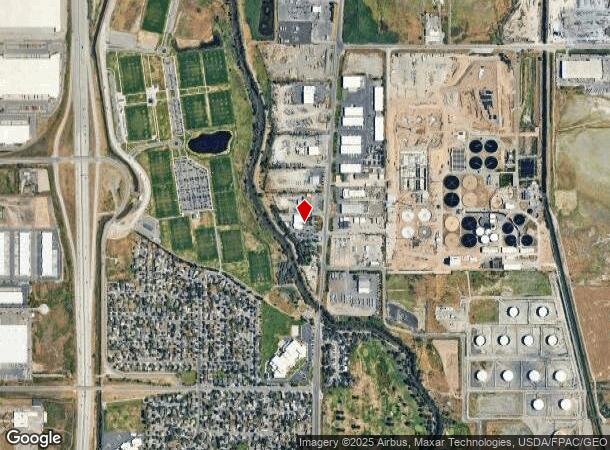
Property Record
2021 N Redwood Rd, Salt Lake City, UT 84116

Current Lease Availabilities
NEARBY LISTINGS FOR SALE OR LEASE
Property Detail
2021 N Redwood Rd
Salt Lake City
Midland
Salt Lake City, UT
BEG AT A PT ON W LINE OF REDWOOD ROAD 33.81 FT E OF THE NE COR LOT 12, BLK 1, MIDLAND, FIVE AC PLAT; S 3^53' W 324.75 FT, M
08-22-100-007-0000
Salt Lake
Warehouse
Utah
2021
12
2021
2.84 AC
114700
Airport
16,400 SF
DEMOGRAPHICS near 2021 N Redwood Rd
1 Mile
3 Mile
5 Mile
2024 Total Population
4,563
47,904
146,315
2029 Population
4,577
49,315
151,511
Pop Growth 2024-2029
+ 0.31%
+ 2.95%
+ 3.55%
Average Age
34
35
36
2024 Total Households
1,194
16,485
59,111
HH Growth 2024-2029
+ 0.17%
+ 3.08%
+ 3.91%
Median Household Inc
$67,630
$63,947
$64,192
Avg Household Size
3.40
2.80
2.40
2024 Avg HH Vehicles
2.00
2.00
2.00
Median Home Value
$330,410
$351,291
$412,752
Median Year Built
1985
1984
1982
Nearby Places
- Restaurants
- Banks
- Shops
- Fitness
- Groceries
PUBLIC TRANSPORTATION
COMMUTER RAIL
Warm Springs Relief Point (FrontRunner - Utah Transit Authority (UTA))
DRIVE
WALK
Distance
Warm Springs Relief Point (FrontRunner - Utah Transit Authority (UTA))
10 min
4.6 mi
North Temple Station (FrontRunner - Utah Transit Authority (UTA))
DRIVE
WALK
Distance
North Temple Station (FrontRunner - Utah Transit Authority (UTA))
10 min
4.6 mi
AIRPORT
Salt Lake City International
DRIVE
WALK
Distance
Salt Lake City International
12 min
6.7 mi
Freight Ports
Port of Stockton
DRIVE
WALK
Distance
Port of Stockton
712 min
697.1 mi
Nearby Properties
Address
Land Use
TOTAL SIZE
Lot Size
Zoning
Address
Land Use
TOTAL SIZE
Lot Size
Zoning
1,523,947 SF
37.63 AC
AIR
Address
Land Use
TOTAL SIZE
Lot Size
Zoning
1,140,230 SF
53.87 AC
B-P
Address
Land Use
TOTAL SIZE
Lot Size
Zoning
248,345 SF
50 AC
PL
Address
Land Use
TOTAL SIZE
Lot Size
Zoning
252,420 SF
15.26 AC
TSA-MU
Address
Land Use
TOTAL SIZE
Lot Size
Zoning
472.94 AC
AIRPRT
Address
Land Use
TOTAL SIZE
Lot Size
Zoning
86,072 SF
240 AC
AIRPOR
Address
Land Use
TOTAL SIZE
Lot Size
Zoning
146,652 SF
16.63 AC
RMF-45
Address
Land Use
TOTAL SIZE
Lot Size
Zoning
170,322 SF
20.46 AC
M-2
Address
Land Use
TOTAL SIZE
Lot Size
Zoning
878,018 SF
2.08 AC
R-MU
Address
Land Use
TOTAL SIZE
Lot Size
Zoning
434,985 SF
74.85 AC
AIRPOR
Address
Land Use
TOTAL SIZE
Lot Size
Zoning
243,202 SF
18.71 AC
BP
Address
Land Use
TOTAL SIZE
Lot Size
Zoning
77,693 SF
2.99 AC
TSA-MU
Address
Land Use
TOTAL SIZE
Lot Size
Zoning
6,673 SF
345.82 AC
Address
Land Use
TOTAL SIZE
Lot Size
Zoning
127,348 SF
4.55 AC
BP
Address
Land Use
TOTAL SIZE
Lot Size
Zoning
637 AC
AIRPRT
Address
Land Use
TOTAL SIZE
Lot Size
Zoning
463,000 SF
25.21 AC
B-P
Address
Land Use
TOTAL SIZE
Lot Size
Zoning
120 AC
AIRPOR
Address
Land Use
TOTAL SIZE
Lot Size
Zoning
65,127 SF
5.17 AC
TSA-MU
Address
Land Use
TOTAL SIZE
Lot Size
Zoning
111,100 SF
7.49 AC
RMF-35
Address
Land Use
TOTAL SIZE
Lot Size
Zoning
354,506 SF
18.44 AC
B-P
Address
Land Use
TOTAL SIZE
Lot Size
Zoning
230,747 SF
21.65 AC
M-1
Address
Land Use
TOTAL SIZE
Lot Size
Zoning
380,631 SF
20.34 AC
BP
Address
Land Use
TOTAL SIZE
Lot Size
Zoning
237.57 AC
AIRPOR
Address
Land Use
TOTAL SIZE
Lot Size
Zoning
341,830 SF
17.75 AC
BP
Address
Land Use
TOTAL SIZE
Lot Size
Zoning
74,454 SF
12.17 AC
RMF-30
Address
Land Use
TOTAL SIZE
Lot Size
Zoning
167,620 SF
114.91 AC
M-1
Address
Land Use
TOTAL SIZE
Lot Size
Zoning
87,913 SF
18.05 AC
PL
Address
Land Use
TOTAL SIZE
Lot Size
Zoning
179.70 AC
AIRPOR
Address
Land Use
TOTAL SIZE
Lot Size
Zoning
123,141 SF
14.63 AC
TSAMUE
Address
Land Use
TOTAL SIZE
Lot Size
Zoning
567,937 SF
3.08 AC
TSAUNT
The World's #1 Commercial Real Estate Marketplace
Connect with us
© 2025 CoStar Group
The information above has been obtained from sources believed reliable. While we do not doubt its accuracy we have not verified it and make no guarantee, warranty or representation about it. It is your responsibility to independently confirm its accuracy and completeness. Any projections, opinions, assumptions, or estimates used are for example only and do not represent the current or future performance of the property. The value of this transaction to you depends on tax and other factors which should be evaluated by your tax, financial, and legal advisors. You and your advisors should conduct a careful, independent investigation of the property to determine to your satisfaction the suitability of the property for your needs.