Property Record
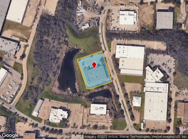
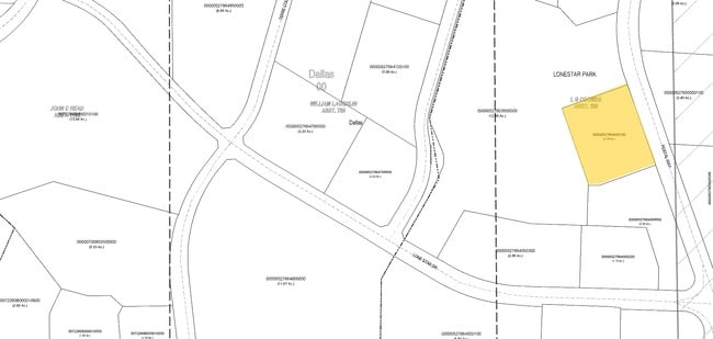
2021 Postal Way, Dallas, TX 75212

NEARBY LISTINGS FOR SALE OR LEASE
Property Detail
2021 Postal Way
Dallas-Fort Worth-Arlington, TX
Lone Star Park
00000527664000100
LONE STAR PARK BLK A/6159 PT LT 3 ACS 2.1150 INT201900063967 DD03142019 CO-DC 6159 00A 00301 2006159 00A
Officebuilding
Dallas
X
Texas
48113C0340J
3
0
2.12 AC
2025
Eastern Lonestar/Tpke
020500
Dallas/Ft Worth
27,300 SF
DEMOGRAPHICS near 2021 Postal Way
1 Mile
3 Mile
5 Mile
2024 Total Population
8,042
105,871
322,828
2029 Population
8,058
106,231
323,942
Pop Growth 2024-2029
+ 0.20%
+ 0.34%
+ 0.35%
Average Age
37
36
36
2024 Total Households
3,406
36,248
135,843
HH Growth 2024-2029
+ 0.59%
+ 0.44%
+ 0.64%
Median Household Inc
$46,867
$54,292
$63,938
Avg Household Size
2.30
2.70
2.30
2024 Avg HH Vehicles
2.00
2.00
2.00
Median Home Value
$345,502
$258,335
$250,653
Median Year Built
1980
1968
1989
Nearby Places
Map Layers
Map Styles
 Street
 Aerial
- Restaurants
- Banks
- Shops
- Fitness
- Groceries
PUBLIC TRANSPORTATION
COMMUTER RAIL
Medical/Market Center (Trinity Railway Express - Dallas Area Rapid Transit (DART))
DRIVE
WALK
Distance
Medical/Market Center (Trinity Railway Express - Dallas Area Rapid Transit (DART))
9 min
4.1 mi
DRIVE
WALK
Distance
9 min
4.1 mi
AIRPORT
Dallas Love Field
DRIVE
WALK
Distance
Dallas Love Field
16 min
6.6 mi
Dallas-Fort Worth International
DRIVE
WALK
Distance
Dallas-Fort Worth International
28 min
20.7 mi
Nearby Properties
Address
Land Use
TOTAL SIZE
Lot Size
Zoning
Address
Land Use
TOTAL SIZE
Lot Size
Zoning
1,298,826 SF
33.16 AC
Z163
Address
Land Use
TOTAL SIZE
Lot Size
Zoning
512,667 SF
16.10 AC
Z151
Address
Land Use
TOTAL SIZE
Lot Size
Zoning
723,546 SF
16.98 AC
Z46
Address
Land Use
TOTAL SIZE
Lot Size
Zoning
307,597 SF
15.21 AC
Z116
Address
Land Use
TOTAL SIZE
Lot Size
Zoning
226,948 SF
20.73 AC
Z239
Address
Land Use
TOTAL SIZE
Lot Size
Zoning
1,259,199 SF
29.32 AC
Z116
Address
Land Use
TOTAL SIZE
Lot Size
Zoning
732,117 SF
5 AC
Z239
Address
Land Use
TOTAL SIZE
Lot Size
Zoning
1,085,000 SF
88.02 AC
Address
Land Use
TOTAL SIZE
Lot Size
Zoning
724,888 SF
2.59 AC
Address
Land Use
TOTAL SIZE
Lot Size
Zoning
316,447 SF
12.61 AC
Z164
Address
Land Use
TOTAL SIZE
Lot Size
Zoning
2,319,440 SF
90.19 AC
Address
Land Use
TOTAL SIZE
Lot Size
Zoning
615,204 SF
5.92 AC
Z116
Address
Land Use
TOTAL SIZE
Lot Size
Zoning
1,010,500 SF
45.40 AC
Z116
Address
Land Use
TOTAL SIZE
Lot Size
Zoning
419,729 SF
3.62 AC
Z115
Address
Land Use
TOTAL SIZE
Lot Size
Zoning
480,202 SF
4.92 AC
Z151
Address
Land Use
TOTAL SIZE
Lot Size
Zoning
1,478,720 SF
6.79 AC
Z239
Address
Land Use
TOTAL SIZE
Lot Size
Zoning
506,299 SF
4.24 AC
Z116
Address
Land Use
TOTAL SIZE
Lot Size
Zoning
763,960 SF
41.01 AC
Address
Land Use
TOTAL SIZE
Lot Size
Zoning
646,211 SF
5.79 AC
Z239
Address
Land Use
TOTAL SIZE
Lot Size
Zoning
513,833 SF
0.17 AC
Z59
Address
Land Use
TOTAL SIZE
Lot Size
Zoning
283,359 SF
16.25 AC
Z116
Address
Land Use
TOTAL SIZE
Lot Size
Zoning
100 SF
37.84 AC
Z115
Address
Land Use
TOTAL SIZE
Lot Size
Zoning
498,588 SF
4.33 AC
Z115
Address
Land Use
TOTAL SIZE
Lot Size
Zoning
466,681 SF
3.55 AC
Z239
Address
Land Use
TOTAL SIZE
Lot Size
Zoning
316,640 SF
5.02 AC
Z115
Address
Land Use
TOTAL SIZE
Lot Size
Zoning
512,628 SF
2.72 AC
Z239
Address
Land Use
TOTAL SIZE
Lot Size
Zoning
290,902 SF
13.90 AC
Z151
Address
Land Use
TOTAL SIZE
Lot Size
Zoning
513,100 SF
3.23 AC
Z239
Address
Land Use
TOTAL SIZE
Lot Size
Zoning
516,478 SF
32.06 AC
Z116
Address
Land Use
TOTAL SIZE
Lot Size
Zoning
672,775 SF
36.29 AC
The World's #1 Commercial Real Estate Marketplace
Connect with us
© 2025 CoStar Group
The information above has been obtained from sources believed reliable. While we do not doubt its accuracy we have not verified it and make no guarantee, warranty or representation about it. It is your responsibility to independently confirm its accuracy and completeness. Any projections, opinions, assumptions, or estimates used are for example only and do not represent the current or future performance of the property. The value of this transaction to you depends on tax and other factors which should be evaluated by your tax, financial, and legal advisors. You and your advisors should conduct a careful, independent investigation of the property to determine to your satisfaction the suitability of the property for your needs.