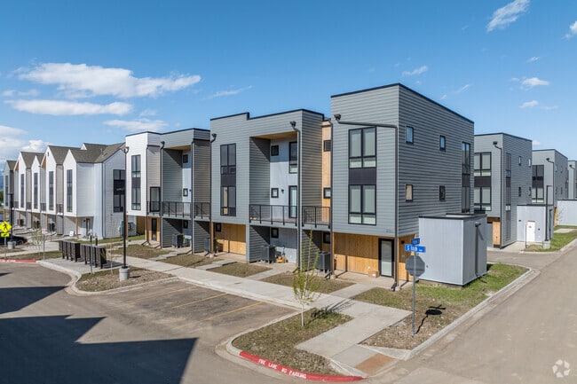
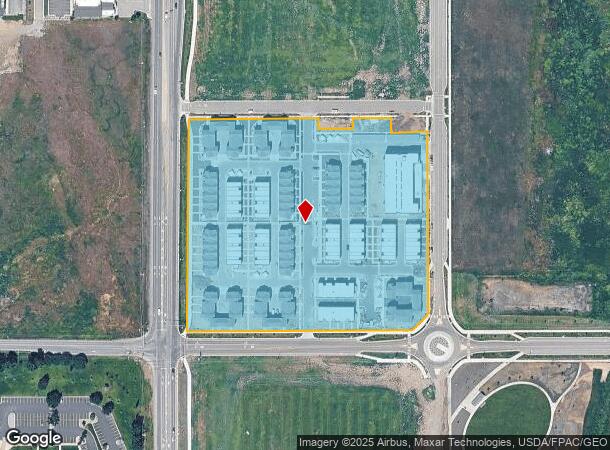
Property Record
2021 S 19Th Ave, Bozeman, MT 59718
NEARBY LISTINGS FOR SALE OR LEASE
Property Detail
2021 S 19Th Ave
Other Market Areas
South University District Ph 3
Bozeman, MT
SOUTH UNIVERSITY DISTRICT PH 3, S24, T02 S, R05 E, BLOCK 2, LOT 1, ACRES 8.6, PER PLAT J-695
06-0798-13-3-06-01-0000
Gallatin
Gardenaptcourtapt5plusunits
Montana
2025
1
2025
8.60 AC
000505
Bozeman/Yellowstone Country
7,552 SF
DEMOGRAPHICS near 2021 S 19Th Ave
1 Mile
3 Mile
5 Mile
2024 Total Population
10,956
56,920
75,870
2029 Population
12,263
64,544
86,155
Pop Growth 2024-2029
+ 11.93%
+ 13.39%
+ 13.56%
Average Age
28
36
36
2024 Total Households
3,193
23,170
30,887
HH Growth 2024-2029
+ 14.66%
+ 14.26%
+ 14.33%
Median Household Inc
$63,716
$69,982
$80,208
Avg Household Size
2.40
2.20
2.30
2024 Avg HH Vehicles
2.00
2.00
2.00
Median Home Value
$694,152
$599,200
$617,092
Median Year Built
2002
1998
2002
Nearby Places
Map Layers
Map Styles
 Street
 Aerial
- Restaurants
- Banks
- Shops
- Fitness
- Groceries
PUBLIC TRANSPORTATION
AIRPORT
Bozeman Yellowstone International
DRIVE
WALK
Distance
Bozeman Yellowstone International
19 min
11.1 mi
Freight Ports
Port of Everett
DRIVE
WALK
Distance
Port of Everett
750 min
701.5 mi
Nearby Properties
Address
Land Use
TOTAL SIZE
Lot Size
Zoning
Address
Land Use
TOTAL SIZE
Lot Size
Zoning
175,398 SF
34.43 AC
Address
Land Use
TOTAL SIZE
Lot Size
Zoning
15,099 SF
16.05 AC
Address
Land Use
TOTAL SIZE
Lot Size
Zoning
33,109 SF
9.89 AC
Address
Land Use
TOTAL SIZE
Lot Size
Zoning
67,716 SF
38.83 AC
Address
Land Use
TOTAL SIZE
Lot Size
Zoning
89,441 SF
0.46 AC
6
Address
Land Use
TOTAL SIZE
Lot Size
Zoning
23,325 SF
9.82 AC
Address
Land Use
TOTAL SIZE
Lot Size
Zoning
69,093 SF
8.96 AC
BP
Address
Land Use
TOTAL SIZE
Lot Size
Zoning
8,100 SF
64.73 AC
Address
Land Use
TOTAL SIZE
Lot Size
Zoning
85,290 SF
7.82 AC
Address
Land Use
TOTAL SIZE
Lot Size
Zoning
20,118 SF
7.95 AC
Address
Land Use
TOTAL SIZE
Lot Size
Zoning
81,620 SF
10.65 AC
1
Address
Land Use
TOTAL SIZE
Lot Size
Zoning
85,052 SF
1.26 AC
6
Address
Land Use
TOTAL SIZE
Lot Size
Zoning
69,917 SF
0.68 AC
6
Address
Land Use
TOTAL SIZE
Lot Size
Zoning
259,349 SF
B2
Address
Land Use
TOTAL SIZE
Lot Size
Zoning
20,106 SF
8.23 AC
Address
Land Use
TOTAL SIZE
Lot Size
Zoning
96,944 SF
0.44 AC
1
Address
Land Use
TOTAL SIZE
Lot Size
Zoning
119,732 SF
7.32 AC
Address
Land Use
TOTAL SIZE
Lot Size
Zoning
90,003 SF
17.01 AC
Address
Land Use
TOTAL SIZE
Lot Size
Zoning
11,639 SF
6.69 AC
Address
Land Use
TOTAL SIZE
Lot Size
Zoning
162,081 SF
4.95 AC
Address
Land Use
TOTAL SIZE
Lot Size
Zoning
19,938 SF
Address
Land Use
TOTAL SIZE
Lot Size
Zoning
90,347 SF
1.74 AC
5
Address
Land Use
TOTAL SIZE
Lot Size
Zoning
27,219 SF
10.11 AC
R3
Address
Land Use
TOTAL SIZE
Lot Size
Zoning
34,198 SF
5.30 AC
Address
Land Use
TOTAL SIZE
Lot Size
Zoning
128,745 SF
4.24 AC
Address
Land Use
TOTAL SIZE
Lot Size
Zoning
162.22 AC
Address
Land Use
TOTAL SIZE
Lot Size
Zoning
59,860 SF
42.94 AC
Address
Land Use
TOTAL SIZE
Lot Size
Zoning
94,146 SF
7.18 AC
R3
Address
Land Use
TOTAL SIZE
Lot Size
Zoning
97,504 SF
0.56 AC
The World's #1 Commercial Real Estate Marketplace
Connect with us
© 2026 CoStar Group
The information above has been obtained from sources believed reliable. While we do not doubt its accuracy we have not verified it and make no guarantee, warranty or representation about it. It is your responsibility to independently confirm its accuracy and completeness. Any projections, opinions, assumptions, or estimates used are for example only and do not represent the current or future performance of the property. The value of this transaction to you depends on tax and other factors which should be evaluated by your tax, financial, and legal advisors. You and your advisors should conduct a careful, independent investigation of the property to determine to your satisfaction the suitability of the property for your needs.