Property Record
20210 E Smoky Hill Rd, Centennial, CO 80015

Current Lease Availabilities
NEARBY LISTINGS FOR SALE OR LEASE
-
-
View all Centennial listings for lease on LoopNet.com
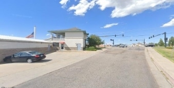
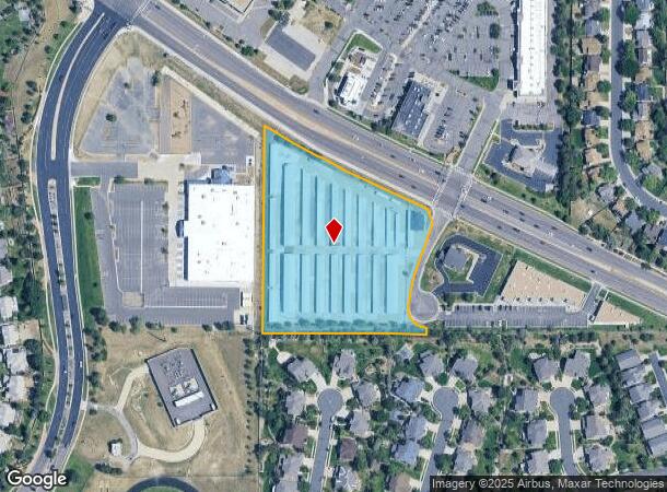
Property Detail
20210 E Smoky Hill Rd
Denver-Aurora-Centennial, CO
The View 2Nd Flg
2073-14-3-30-003
SUBDIVISIONCD 062249 SUBDIVISIONNAME THE VIEW 2ND FLG BLOCK 001 LOT 003 LOT 3 BLK 1 THE VIEW 2ND FLG
Publicstorage
Arapahoe
X
Colorado
08005C0482M
003,3
2024
4.56 AC
2025
Outlying Arapahoe County
085200
Denver
65,560 SF
DEMOGRAPHICS near 20210 E Smoky Hill Rd
1 mile
3 mile
5 mile
2024 Total Population
15,036
115,154
238,629
2029 Population
14,849
115,242
242,116
Pop Growth 2024-2029
(1.24%)
+ 0.08%
+ 1.46%
Average Age
39
38
38
2024 Total Households
4,699
37,596
83,515
HH Growth 2024-2029
(1.28%)
(0.04%)
+ 1.62%
Median Household Inc
$142,730
$119,915
$108,191
Avg Household Size
3.20
3.00
2.80
2024 Avg HH Vehicles
2.00
2.00
2.00
Median Home Value
$516,299
$508,280
$488,730
Median Year Built
1994
1997
1997
Nearby Places
Map Layers
Map Styles
 Street
 Aerial
Transit
 Traffic
 Biking
Places
Listings with unknown addresses are not visible on the map
- Restaurants
- Banks
- Shops
- Fitness
- Groceries
PUBLIC TRANSPORTATION
AIRPORT
Denver International
Drive
Walk
Distance
Denver International
30 min
24.8 mi
Nearby Properties
Address
Land Use
TOTAL SIZE
Lot Size
Zoning
Address
Land Use
TOTAL SIZE
Lot Size
Zoning
234,214 SF
5.23 AC
Address
Land Use
TOTAL SIZE
Lot Size
Zoning
280,586 SF
60.97 AC
RPD
Address
Land Use
TOTAL SIZE
Lot Size
Zoning
502,000 SF
22.32 AC
RPD
Address
Land Use
TOTAL SIZE
Lot Size
Zoning
525,600 SF
57.90 AC
Address
Land Use
TOTAL SIZE
Lot Size
Zoning
346,890 SF
38.99 AC
AA1
Address
Land Use
TOTAL SIZE
Lot Size
Zoning
328,000 SF
33.52 AC
PUD
Address
Land Use
TOTAL SIZE
Lot Size
Zoning
448,149 SF
33.62 AC
RE470
Address
Land Use
TOTAL SIZE
Lot Size
Zoning
217,273 SF
18.28 AC
Address
Land Use
TOTAL SIZE
Lot Size
Zoning
168,500 SF
24.03 AC
Address
Land Use
TOTAL SIZE
Lot Size
Zoning
166,431 SF
19.37 AC
Address
Land Use
TOTAL SIZE
Lot Size
Zoning
12,726 SF
17.94 AC
Address
Land Use
TOTAL SIZE
Lot Size
Zoning
137,372 SF
5.86 AC
Address
Land Use
TOTAL SIZE
Lot Size
Zoning
129,701 SF
6.56 AC
Address
Land Use
TOTAL SIZE
Lot Size
Zoning
106,000 SF
27.41 AC
Address
Land Use
TOTAL SIZE
Lot Size
Zoning
376,563 SF
12.17 AC
AMU
Address
Land Use
TOTAL SIZE
Lot Size
Zoning
14,600 SF
0.28 AC
WDC2A*
Address
Land Use
TOTAL SIZE
Lot Size
Zoning
489,120 SF
20.10 AC
RE470
Address
Land Use
TOTAL SIZE
Lot Size
Zoning
319,078 SF
18.49 AC
RE470
Address
Land Use
TOTAL SIZE
Lot Size
Zoning
176,000 SF
10.83 AC
PUD
Address
Land Use
TOTAL SIZE
Lot Size
Zoning
151,246 SF
13.25 AC
RE470
Address
Land Use
TOTAL SIZE
Lot Size
Zoning
105,244 SF
12.64 AC
RPCZD
Address
Land Use
TOTAL SIZE
Lot Size
Zoning
308,396 SF
19.45 AC
RPCZD
Address
Land Use
TOTAL SIZE
Lot Size
Zoning
379,109 SF
16.45 AC
Address
Land Use
TOTAL SIZE
Lot Size
Zoning
26,880 SF
20.44 AC
Address
Land Use
TOTAL SIZE
Lot Size
Zoning
298,589 SF
14.52 AC
RPCZD
Address
Land Use
TOTAL SIZE
Lot Size
Zoning
65,120 SF
11.17 AC
Address
Land Use
TOTAL SIZE
Lot Size
Zoning
206,064 SF
25.38 AC
AMU
Address
Land Use
TOTAL SIZE
Lot Size
Zoning
40,935 SF
3.38 AC
RE470
Address
Land Use
TOTAL SIZE
Lot Size
Zoning
172,715 SF
4.23 AC
Address
Land Use
TOTAL SIZE
Lot Size
Zoning
206,122 SF
24.97 AC
The World's #1 Commercial Real Estate Marketplace
Connect with us
© 2026 CoStar Group
The information above has been obtained from sources believed reliable. While we do not doubt its accuracy we have not verified it and make no guarantee, warranty or representation about it. It is your responsibility to independently confirm its accuracy and completeness. Any projections, opinions, assumptions, or estimates used are for example only and do not represent the current or future performance of the property. The value of this transaction to you depends on tax and other factors which should be evaluated by your tax, financial, and legal advisors. You and your advisors should conduct a careful, independent investigation of the property to determine to your satisfaction the suitability of the property for your needs.