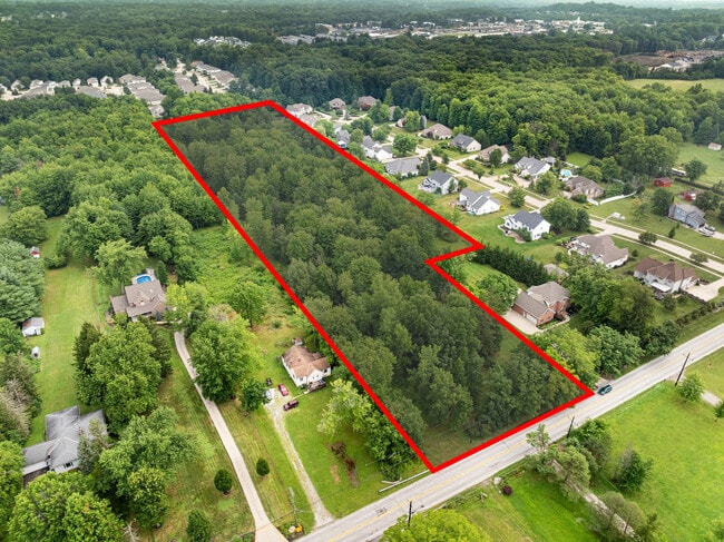
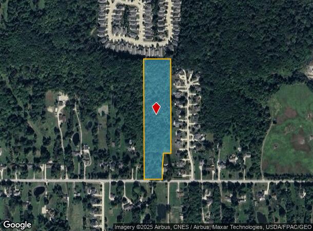
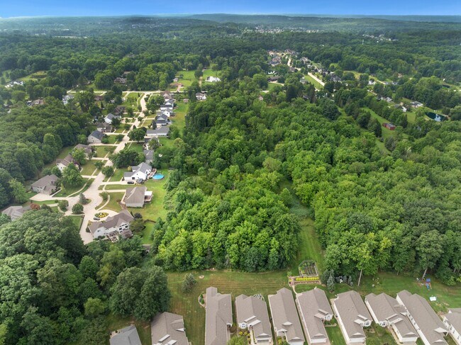
Property Record
2022 Akins Rd, Broadview Heights, OH 44147
This Property Is For Sale
NEARBY LISTINGS FOR SALE OR LEASE
Property Detail
2022 Akins Rd
Cleveland-Elyria, OH
23
584-13-006
Cuyahoga
Residentialacreage
Ohio
2024
23
2024
9.34 AC
136104
Southwest
1,424 SF
Cleveland
DEMOGRAPHICS near 2022 Akins Rd
1 mile
3 mile
5 mile
2024 Total Population
3,454
35,772
92,356
2029 Population
3,439
35,314
91,523
Pop Growth 2024-2029
(0.43%)
(1.28%)
(0.90%)
Average Age
40
43
44
2024 Total Households
1,443
14,647
38,465
HH Growth 2024-2029
(0.55%)
(1.39%)
(0.98%)
Median Household Inc
$83,024
$100,737
$93,304
Avg Household Size
2.30
2.40
2.30
2024 Avg HH Vehicles
2.00
2.00
2.00
Median Home Value
$391,984
$329,594
$291,027
Median Year Built
1985
1983
1977
Nearby Places
Map Layers
Map Styles
 Street
 Aerial
Transit
 Traffic
 Biking
Places
Listings with unknown addresses are not visible on the map
- Restaurants
- Banks
- Shops
- Fitness
- Groceries
PUBLIC TRANSPORTATION
COMMUTER RAIL
Brecksville (National Park Scenic Railway - Cuyahoga Valley Scenic Railroad)
Drive
Walk
Distance
Brecksville (National Park Scenic Railway - Cuyahoga Valley Scenic Railroad)
14 min
6.6 mi
Canal Exploration Center (National Park Scenic Railway - Cuyahoga Valley Scenic Railroad)
Drive
Walk
Distance
Canal Exploration Center (National Park Scenic Railway - Cuyahoga Valley Scenic Railroad)
17 min
8.8 mi
AIRPORT
Cleveland-Hopkins International
Drive
Walk
Distance
Cleveland-Hopkins International
31 min
16.9 mi
Freight Ports
Port of Toledo
Drive
Walk
Distance
Port of Toledo
143 min
112.8 mi
Nearby Properties
Address
Land Use
TOTAL SIZE
Lot Size
Zoning
Address
Land Use
TOTAL SIZE
Lot Size
Zoning
105,027 SF
14.05 AC
O-L
Address
Land Use
TOTAL SIZE
Lot Size
Zoning
485,330 SF
47.02 AC
TCD
Address
Land Use
TOTAL SIZE
Lot Size
Zoning
154,702 SF
23.37 AC
PF
Address
Land Use
TOTAL SIZE
Lot Size
Zoning
39,848 SF
48 AC
RM-D
Address
Land Use
TOTAL SIZE
Lot Size
Zoning
118,375 SF
24.17 AC
RM-D
Address
Land Use
TOTAL SIZE
Lot Size
Zoning
614 SF
19.13 AC
RRZ
Address
Land Use
TOTAL SIZE
Lot Size
Zoning
166,699 SF
65.80 AC
B-5
Address
Land Use
TOTAL SIZE
Lot Size
Zoning
149,522 SF
19.09 AC
PF
Address
Land Use
TOTAL SIZE
Lot Size
Zoning
48,682 SF
4.64 AC
C-4
Address
Land Use
TOTAL SIZE
Lot Size
Zoning
63,282 SF
20.09 AC
O-B
Address
Land Use
TOTAL SIZE
Lot Size
Zoning
28,189 SF
15.33 AC
B-1OR2
Address
Land Use
TOTAL SIZE
Lot Size
Zoning
10,560 SF
22.12 AC
RM-D
Address
Land Use
TOTAL SIZE
Lot Size
Zoning
74,988 SF
19.16 AC
RM-D
Address
Land Use
TOTAL SIZE
Lot Size
Zoning
24.22 AC
PF
Address
Land Use
TOTAL SIZE
Lot Size
Zoning
204,594 SF
22.97 AC
R1-A
Address
Land Use
TOTAL SIZE
Lot Size
Zoning
24,900 SF
4.42 AC
B-1OR2
Address
Land Use
TOTAL SIZE
Lot Size
Zoning
55,332 SF
3.01 AC
E-2
Address
Land Use
TOTAL SIZE
Lot Size
Zoning
89,807 SF
7.29 AC
Address
Land Use
TOTAL SIZE
Lot Size
Zoning
49,470 SF
6.61 AC
E-1
Address
Land Use
TOTAL SIZE
Lot Size
Zoning
83,495 SF
9.70 AC
E-1
Address
Land Use
TOTAL SIZE
Lot Size
Zoning
131,001 SF
13.47 AC
Address
Land Use
TOTAL SIZE
Lot Size
Zoning
11.97 AC
R-8
Address
Land Use
TOTAL SIZE
Lot Size
Zoning
142,510 SF
13.87 AC
E-2
Address
Land Use
TOTAL SIZE
Lot Size
Zoning
59,813 SF
5.56 AC
Address
Land Use
TOTAL SIZE
Lot Size
Zoning
111,152 SF
80.99 AC
C-F
Address
Land Use
TOTAL SIZE
Lot Size
Zoning
123.70 AC
A-1
Address
Land Use
TOTAL SIZE
Lot Size
Zoning
78,800 SF
38.13 AC
NONE
Address
Land Use
TOTAL SIZE
Lot Size
Zoning
128,610 SF
7.71 AC
C-2
Address
Land Use
TOTAL SIZE
Lot Size
Zoning
102,446 SF
8.21 AC
TCD
Address
Land Use
TOTAL SIZE
Lot Size
Zoning
47,988 SF
10.74 AC
LB
The World's #1 Commercial Real Estate Marketplace
Connect with us
© 2026 CoStar Group
The information above has been obtained from sources believed reliable. While we do not doubt its accuracy we have not verified it and make no guarantee, warranty or representation about it. It is your responsibility to independently confirm its accuracy and completeness. Any projections, opinions, assumptions, or estimates used are for example only and do not represent the current or future performance of the property. The value of this transaction to you depends on tax and other factors which should be evaluated by your tax, financial, and legal advisors. You and your advisors should conduct a careful, independent investigation of the property to determine to your satisfaction the suitability of the property for your needs.