Property Record
2022 Greys Point Rd, Topping, VA 23169
This Property Is For Sale
NEARBY LISTINGS FOR SALE OR LEASE
-
-
View all Topping listings for sale on LoopNet.com
Property Detail
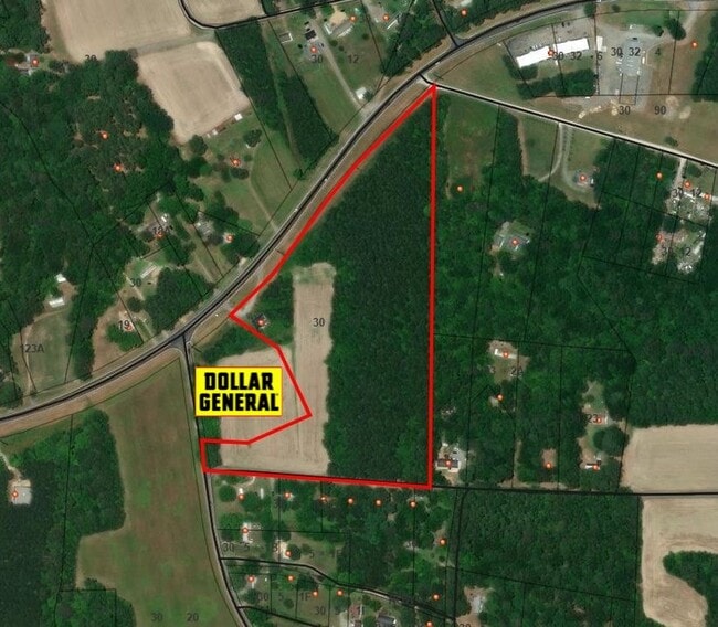
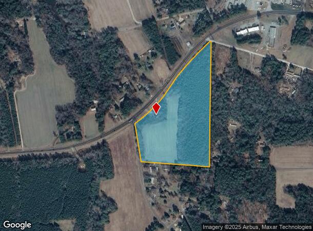
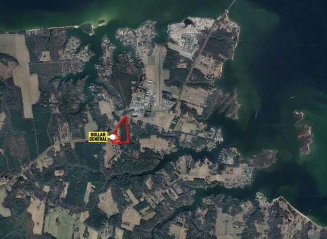
2022 Greys Point Rd
Sfr
LOCKLIES 21.052 AC (LUCA) D139-650,185-1,261-144,P184-800, P7-82, D22-1284
X
Middlesex
51119C0205F
Virginia
2025
21.05 AC
2025
Virginia Regional
951100
Other Market Areas
2,448 SF
30-55
DEMOGRAPHICS near 2022 Greys Point Rd
1 mile
3 mile
5 mile
2024 Total Population
558
2,042
6,245
2029 Population
600
2,214
6,717
Pop Growth 2024-2029
+ 7.53%
+ 8.42%
+ 7.56%
Average Age
48
48
50
2024 Total Households
255
916
2,768
HH Growth 2024-2029
+ 8.24%
+ 8.73%
+ 7.59%
Median Household Inc
$70,981
$71,215
$77,341
Avg Household Size
2.20
2.20
2.10
2024 Avg HH Vehicles
2.00
2.00
2.00
Median Home Value
$296,153
$298,553
$352,419
Median Year Built
1986
1986
1985
Nearby Places
Map Layers
Map Styles
 Street
 Aerial
Transit
 Traffic
 Biking
Places
Listings with unknown addresses are not visible on the map
- Restaurants
- Banks
- Shops
- Fitness
- Groceries
Nearby Properties
Address
Land Use
TOTAL SIZE
Lot Size
Zoning
Address
Land Use
TOTAL SIZE
Lot Size
Zoning
4,088 SF
131.35 AC
WC
Address
Land Use
TOTAL SIZE
Lot Size
Zoning
53.09 AC
LDR
Address
Land Use
TOTAL SIZE
Lot Size
Zoning
16.34 AC
LDR
Address
Land Use
TOTAL SIZE
Lot Size
Zoning
1,496 SF
21.01 AC
GB
Address
Land Use
TOTAL SIZE
Lot Size
Zoning
936 SF
320.79 AC
LDR
Address
Land Use
TOTAL SIZE
Lot Size
Zoning
1,056 SF
124.94 AC
LDR
Address
Land Use
TOTAL SIZE
Lot Size
Zoning
760 SF
8.44 AC
WC
Address
Land Use
TOTAL SIZE
Lot Size
Zoning
1,715 SF
11.11 AC
VC
Address
Land Use
TOTAL SIZE
Lot Size
Zoning
8,634 SF
2.75 AC
LDR
Address
Land Use
TOTAL SIZE
Lot Size
Zoning
6,375 SF
5 AC
LDR
Address
Land Use
TOTAL SIZE
Lot Size
Zoning
3,575 SF
3.33 AC
LDR
Address
Land Use
TOTAL SIZE
Lot Size
Zoning
7,886 SF
6.03 AC
LDR
Address
Land Use
TOTAL SIZE
Lot Size
Zoning
6,421 SF
1.47 AC
LDR
Address
Land Use
TOTAL SIZE
Lot Size
Zoning
5,812 SF
15.15 AC
LDR
Address
Land Use
TOTAL SIZE
Lot Size
Zoning
8,348 SF
6 AC
VC
Address
Land Use
TOTAL SIZE
Lot Size
Zoning
9,100 SF
2.01 AC
GB
Address
Land Use
TOTAL SIZE
Lot Size
Zoning
62.63 AC
LDR
Address
Land Use
TOTAL SIZE
Lot Size
Zoning
9,379 SF
31.73 AC
LDR
Address
Land Use
TOTAL SIZE
Lot Size
Zoning
2,198 SF
7.56 AC
LDR
Address
Land Use
TOTAL SIZE
Lot Size
Zoning
2,338 SF
10.06 AC
LDR
Address
Land Use
TOTAL SIZE
Lot Size
Zoning
3,682 SF
2.71 AC
LDR
Address
Land Use
TOTAL SIZE
Lot Size
Zoning
3,187 SF
11.49 AC
WC
Address
Land Use
TOTAL SIZE
Lot Size
Zoning
1,344 SF
1.04 AC
WC
Address
Land Use
TOTAL SIZE
Lot Size
Zoning
3,032 SF
9.37 AC
LDR
Address
Land Use
TOTAL SIZE
Lot Size
Zoning
3,631 SF
1.43 AC
LDR
Address
Land Use
TOTAL SIZE
Lot Size
Zoning
4,736 SF
1.59 AC
GB
Address
Land Use
TOTAL SIZE
Lot Size
Zoning
2,200 SF
9.60 AC
LDR
Address
Land Use
TOTAL SIZE
Lot Size
Zoning
2,707 SF
9.90 AC
LDR
Address
Land Use
TOTAL SIZE
Lot Size
Zoning
3,304 SF
1.22 AC
LDR
Address
Land Use
TOTAL SIZE
Lot Size
Zoning
3,209 SF
0.96 AC
LDR
The World's #1 Commercial Real Estate Marketplace
Connect with us
© 2026 CoStar Group
The information above has been obtained from sources believed reliable. While we do not doubt its accuracy we have not verified it and make no guarantee, warranty or representation about it. It is your responsibility to independently confirm its accuracy and completeness. Any projections, opinions, assumptions, or estimates used are for example only and do not represent the current or future performance of the property. The value of this transaction to you depends on tax and other factors which should be evaluated by your tax, financial, and legal advisors. You and your advisors should conduct a careful, independent investigation of the property to determine to your satisfaction the suitability of the property for your needs.