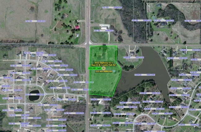
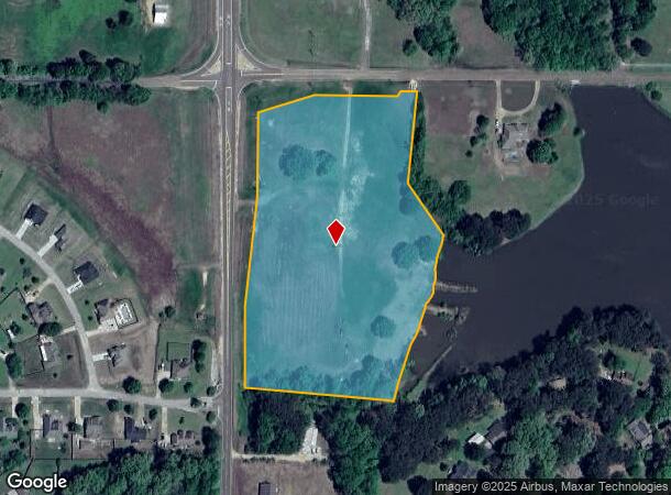
Property Record
2022 Highway 51 S, Senatobia, MS 38668
NEARBY LISTINGS FOR SALE OR LEASE
Property Detail
2022 Highway 51 S
153K-02-0002900
PT NW 1/4 NW 1/4
Agriculturalland
Tate
X
Mississippi
28107C0075D
10.10 AC
2025
Tate County
2025
Memphis
950201
Memphis, TN-MS-AR
DEMOGRAPHICS near 2022 Highway 51 S
1 Mile
3 Mile
5 Mile
2024 Total Population
669
8,044
12,020
2029 Population
681
8,240
12,241
Pop Growth 2024-2029
+ 1.79%
+ 2.44%
+ 1.84%
Average Age
38
37
37
2024 Total Households
207
2,716
4,099
HH Growth 2024-2029
+ 1.93%
+ 2.61%
+ 1.88%
Median Household Inc
$66,684
$59,199
$59,010
Avg Household Size
2.80
2.60
2.60
2024 Avg HH Vehicles
2.00
2.00
2.00
Median Home Value
$157,303
$171,540
$178,662
Median Year Built
1995
1990
1990
Nearby Places
Map Layers
Map Styles
 Street
 Aerial
- Restaurants
- Banks
- Shops
- Fitness
- Groceries
Nearby Properties
Address
Land Use
TOTAL SIZE
Lot Size
Zoning
Address
Land Use
TOTAL SIZE
Lot Size
Zoning
Address
Land Use
TOTAL SIZE
Lot Size
Zoning
64,750 SF
38.60 AC
Address
Land Use
TOTAL SIZE
Lot Size
Zoning
5,565 SF
18.70 AC
Address
Land Use
TOTAL SIZE
Lot Size
Zoning
4,250 SF
21.40 AC
Address
Land Use
TOTAL SIZE
Lot Size
Zoning
67,200 SF
166 AC
Address
Land Use
TOTAL SIZE
Lot Size
Zoning
3,103 SF
3.40 AC
Address
Land Use
TOTAL SIZE
Lot Size
Zoning
62,963 SF
10 AC
Address
Land Use
TOTAL SIZE
Lot Size
Zoning
25,032 SF
8 AC
Address
Land Use
TOTAL SIZE
Lot Size
Zoning
10,603 SF
6.10 AC
Address
Land Use
TOTAL SIZE
Lot Size
Zoning
1,866 SF
0.64 AC
Address
Land Use
TOTAL SIZE
Lot Size
Zoning
86,995 SF
6.45 AC
Address
Land Use
TOTAL SIZE
Lot Size
Zoning
20,098 SF
1.20 AC
Address
Land Use
TOTAL SIZE
Lot Size
Zoning
11,002 SF
2.03 AC
Address
Land Use
TOTAL SIZE
Lot Size
Zoning
6,238 SF
38.20 AC
Address
Land Use
TOTAL SIZE
Lot Size
Zoning
4,043 SF
136 AC
Address
Land Use
TOTAL SIZE
Lot Size
Zoning
9,744 SF
1.04 AC
Address
Land Use
TOTAL SIZE
Lot Size
Zoning
2,724 SF
8 AC
Address
Land Use
TOTAL SIZE
Lot Size
Zoning
8,800 SF
8.40 AC
Address
Land Use
TOTAL SIZE
Lot Size
Zoning
8,241 SF
2 AC
Address
Land Use
TOTAL SIZE
Lot Size
Zoning
18,012 SF
2.70 AC
Address
Land Use
TOTAL SIZE
Lot Size
Zoning
5,000 SF
2.20 AC
Address
Land Use
TOTAL SIZE
Lot Size
Zoning
5,270 SF
1.20 AC
Address
Land Use
TOTAL SIZE
Lot Size
Zoning
9,900 SF
1.60 AC
Address
Land Use
TOTAL SIZE
Lot Size
Zoning
6,618 SF
0.81 AC
Address
Land Use
TOTAL SIZE
Lot Size
Zoning
24,140 SF
Address
Land Use
TOTAL SIZE
Lot Size
Zoning
8,400 SF
1.20 AC
Address
Land Use
TOTAL SIZE
Lot Size
Zoning
10,552 SF
1.40 AC
Address
Land Use
TOTAL SIZE
Lot Size
Zoning
1,500 SF
0.81 AC
The World's #1 Commercial Real Estate Marketplace
Connect with us
© 2026 CoStar Group
The information above has been obtained from sources believed reliable. While we do not doubt its accuracy we have not verified it and make no guarantee, warranty or representation about it. It is your responsibility to independently confirm its accuracy and completeness. Any projections, opinions, assumptions, or estimates used are for example only and do not represent the current or future performance of the property. The value of this transaction to you depends on tax and other factors which should be evaluated by your tax, financial, and legal advisors. You and your advisors should conduct a careful, independent investigation of the property to determine to your satisfaction the suitability of the property for your needs.