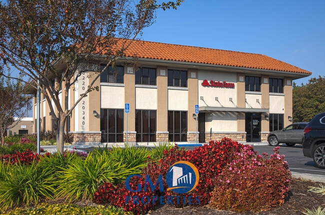
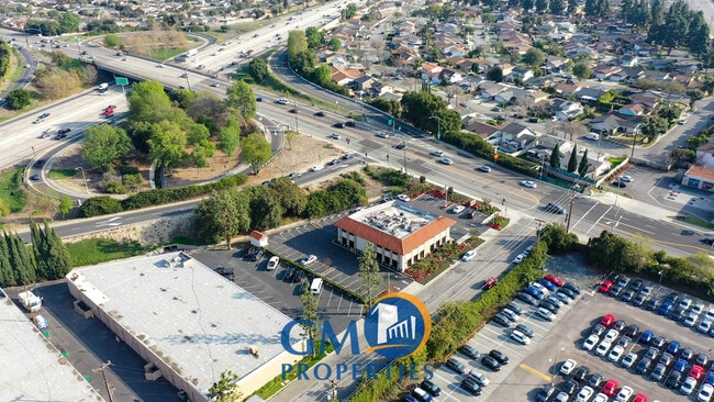
Property Record
20220 State Rd, Cerritos, CA 90703

Current Lease Availabilities
NEARBY LISTINGS FOR SALE OR LEASE
Property Detail
20220 State Rd
Los Angeles-Long Beach-Glendale, CA
28717
7049-021-011
*TR=RANCHO LOS COYOTES SECTIONS TOWNSHIP AND RANGE AS PER PATENTS BK 1 PGS 493- 494 AND ORM 7425 PGS 20-21*LOT COM AT SE COR OF LOT 1 TR NO 28717 TH SW ON SE LINE OF SD LOT AND SW PROLONGATION BEG TH N 13 1041 E 65.91 FT TO BEG
Parkinglot
Los Angeles
X
California
06037C1980F
1
2024
0.08 AC
2025
Mid-Cities
554522
Los Angeles
DEMOGRAPHICS near 20220 State Rd
1 Mile
3 Mile
5 Mile
2024 Total Population
24,904
214,519
567,920
2029 Population
23,989
207,598
550,202
Pop Growth 2024-2029
(3.67%)
(3.23%)
(3.12%)
Average Age
41
41
40
2024 Total Households
7,761
69,136
178,955
HH Growth 2024-2029
(3.96%)
(3.46%)
(3.34%)
Median Household Inc
$98,648
$101,827
$93,350
Avg Household Size
3.10
3.00
3.10
2024 Avg HH Vehicles
2.00
2.00
2.00
Median Home Value
$746,705
$749,533
$739,224
Median Year Built
1961
1961
1961
Nearby Places
- Restaurants
- Banks
- Shops
- Fitness
- Groceries
PUBLIC TRANSPORTATION
COMMUTER RAIL
Norwalk/Santa Fe Springs (91 Line - Southern California Regional Rail Authority (Metrolink), Orange County Line - Southern California Regional Rail Authority (Metrolink))
DRIVE
WALK
Distance
Norwalk/Santa Fe Springs (91 Line - Southern California Regional Rail Authority (Metrolink), Orange County Line - Southern California Regional Rail Authority (Metrolink))
13 min
7.8 mi
Buena Park (91 Line - Southern California Regional Rail Authority (Metrolink), Orange County Line - Southern California Regional Rail Authority (Metrolink))
DRIVE
WALK
Distance
Buena Park (91 Line - Southern California Regional Rail Authority (Metrolink), Orange County Line - Southern California Regional Rail Authority (Metrolink))
16 min
8.7 mi
AIRPORT
Long Beach (Daugherty Field)
DRIVE
WALK
Distance
Long Beach (Daugherty Field)
12 min
6.8 mi
John Wayne/Orange County
DRIVE
WALK
Distance
John Wayne/Orange County
27 min
20.5 mi
Los Angeles International
DRIVE
WALK
Distance
Los Angeles International
31 min
24.7 mi
Freight Ports
Port of Long Beach
DRIVE
WALK
Distance
Port of Long Beach
20 min
11.2 mi
Nearby Properties
Address
Land Use
TOTAL SIZE
Lot Size
Zoning
Address
Land Use
TOTAL SIZE
Lot Size
Zoning
324,400 SF
55.03 AC
CECR
Address
Land Use
TOTAL SIZE
Lot Size
Zoning
202,924 SF
99.50 AC
LKC4*
Address
Land Use
TOTAL SIZE
Lot Size
Zoning
235,971 SF
10.58 AC
HGC4*
Address
Land Use
TOTAL SIZE
Lot Size
Zoning
353,001 SF
4.81 AC
CEM
Address
Land Use
TOTAL SIZE
Lot Size
Zoning
266,337 SF
2.40 AC
CE-ADP-16
Address
Land Use
TOTAL SIZE
Lot Size
Zoning
203,371 SF
0.14 AC
HGC4*
Address
Land Use
TOTAL SIZE
Lot Size
Zoning
1,097,606 SF
52.50 AC
LBPD
Address
Land Use
TOTAL SIZE
Lot Size
Zoning
247,536 SF
5.79 AC
CECR
Address
Land Use
TOTAL SIZE
Lot Size
Zoning
312,469 SF
6.85 AC
LBCCA
Address
Land Use
TOTAL SIZE
Lot Size
Zoning
120,094 SF
5.93 AC
Address
Land Use
TOTAL SIZE
Lot Size
Zoning
140,624 SF
4.35 AC
ATMRV1200*
Address
Land Use
TOTAL SIZE
Lot Size
Zoning
80,114 SF
1.27 AC
LKC4*
Address
Land Use
TOTAL SIZE
Lot Size
Zoning
299,406 SF
1.72 AC
LKC4*
Address
Land Use
TOTAL SIZE
Lot Size
Zoning
76,570 SF
6.46 AC
LBPPD1
Address
Land Use
TOTAL SIZE
Lot Size
Zoning
1,004,620 SF
19.73 AC
CECR
Address
Land Use
TOTAL SIZE
Lot Size
Zoning
132,019 SF
5.22 AC
LKMFR*
Address
Land Use
TOTAL SIZE
Lot Size
Zoning
80,339 SF
5.88 AC
ATCPD*
Address
Land Use
TOTAL SIZE
Lot Size
Zoning
266,036 SF
6.13 AC
ATCS
Address
Land Use
TOTAL SIZE
Lot Size
Zoning
193,300 SF
4.22 AC
CECR
Address
Land Use
TOTAL SIZE
Lot Size
Zoning
131,914 SF
10.15 AC
CECR
Address
Land Use
TOTAL SIZE
Lot Size
Zoning
160,769 SF
5.90 AC
LKC4*
Address
Land Use
TOTAL SIZE
Lot Size
Zoning
175,482 SF
3.13 AC
HGC4*
Address
Land Use
TOTAL SIZE
Lot Size
Zoning
61,098 SF
4.98 AC
CEADP5
Address
Land Use
TOTAL SIZE
Lot Size
Zoning
166,006 SF
1.59 AC
LKC4*
Address
Land Use
TOTAL SIZE
Lot Size
Zoning
493,692 SF
13.35 AC
CECR
Address
Land Use
TOTAL SIZE
Lot Size
Zoning
218,733 SF
12.39 AC
LBPD19
Address
Land Use
TOTAL SIZE
Lot Size
Zoning
7,200 SF
3.73 AC
Address
Land Use
TOTAL SIZE
Lot Size
Zoning
340,346 SF
5.74 AC
CECR
Address
Land Use
TOTAL SIZE
Lot Size
Zoning
148,126 SF
0.69 AC
CEAD P2
Address
Land Use
TOTAL SIZE
Lot Size
Zoning
7,500 SF
30.41 AC
The World's #1 Commercial Real Estate Marketplace
Connect with us
© 2025 CoStar Group
The information above has been obtained from sources believed reliable. While we do not doubt its accuracy we have not verified it and make no guarantee, warranty or representation about it. It is your responsibility to independently confirm its accuracy and completeness. Any projections, opinions, assumptions, or estimates used are for example only and do not represent the current or future performance of the property. The value of this transaction to you depends on tax and other factors which should be evaluated by your tax, financial, and legal advisors. You and your advisors should conduct a careful, independent investigation of the property to determine to your satisfaction the suitability of the property for your needs.