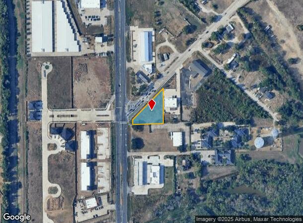
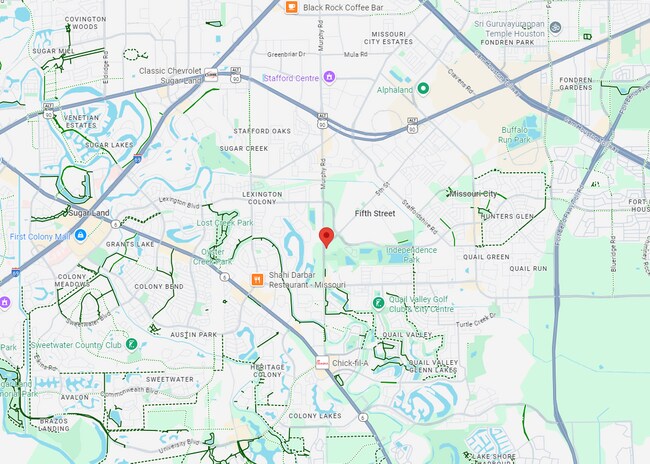
Property Record
2023 5Th St, Stafford, TX 77477
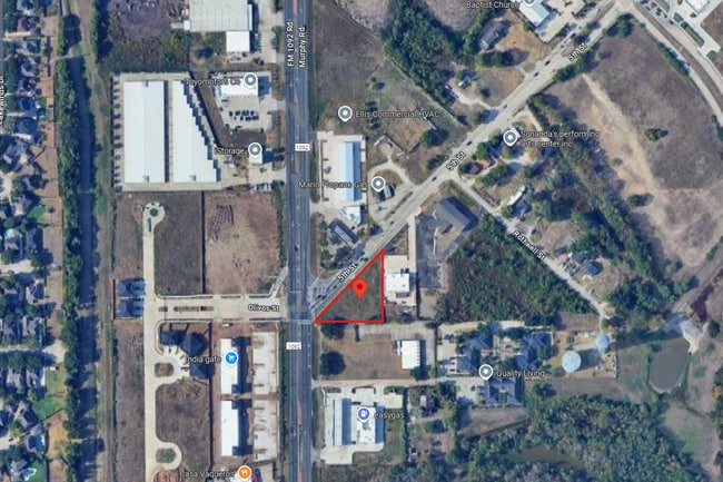
This Property Is For Sale
NEARBY LISTINGS FOR SALE OR LEASE
Property Detail
2023 5Th St
Houston-The Woodlands-Sugar Land, TX
Wm Neal
0064-00-000-2995-907
0064 WM NEAL, BLOCK 1, ACRES 0.6666, UNRESTRICTED RESERVE A, VUVN INC DEVELOPMENT
Residentialacreage
Fort Bend
X
Texas
48157C0280L
0.67 AC
2024
E Fort Bend Co/Sugar Land
2025
Houston
671800
DEMOGRAPHICS near 2023 5Th St
1 Mile
3 Mile
5 Mile
2024 Total Population
15,054
117,553
281,110
2029 Population
20,258
157,806
368,208
Pop Growth 2024-2029
+ 34.57%
+ 34.24%
+ 30.98%
Average Age
42
41
40
2024 Total Households
5,198
41,073
98,122
HH Growth 2024-2029
+ 35.53%
+ 35.26%
+ 31.95%
Median Household Inc
$86,075
$94,014
$93,688
Avg Household Size
2.80
2.80
2.80
2024 Avg HH Vehicles
2.00
2.00
2.00
Median Home Value
$334,900
$326,313
$346,318
Median Year Built
1995
1991
1993
Nearby Places
- Restaurants
- Banks
- Shops
- Fitness
- Groceries
PUBLIC TRANSPORTATION
AIRPORT
William P Hobby
DRIVE
WALK
Distance
William P Hobby
36 min
22.6 mi
George Bush Intcntl/Houston
DRIVE
WALK
Distance
George Bush Intcntl/Houston
52 min
38.8 mi
Freight Ports
Port of Houston
DRIVE
WALK
Distance
Port of Houston
37 min
24.7 mi
Nearby Properties
Address
Land Use
TOTAL SIZE
Lot Size
Zoning
Address
Land Use
TOTAL SIZE
Lot Size
Zoning
257,051 SF
64.85 AC
Address
Land Use
TOTAL SIZE
Lot Size
Zoning
109,083 SF
20.81 AC
Address
Land Use
TOTAL SIZE
Lot Size
Zoning
967,659 SF
75.03 AC
Address
Land Use
TOTAL SIZE
Lot Size
Zoning
344,620 SF
53.65 AC
STHQZ
Address
Land Use
TOTAL SIZE
Lot Size
Zoning
32,520 SF
34.98 AC
Address
Land Use
TOTAL SIZE
Lot Size
Zoning
85,273 SF
11.63 AC
Y
Address
Land Use
TOTAL SIZE
Lot Size
Zoning
93,310 SF
13.41 AC
Address
Land Use
TOTAL SIZE
Lot Size
Zoning
14,038 SF
23.83 AC
Address
Land Use
TOTAL SIZE
Lot Size
Zoning
6.70 AC
Address
Land Use
TOTAL SIZE
Lot Size
Zoning
176,377 SF
40.41 AC
SM
Address
Land Use
TOTAL SIZE
Lot Size
Zoning
127,458 SF
14.21 AC
Address
Land Use
TOTAL SIZE
Lot Size
Zoning
88,682 SF
10.52 AC
ASY
Address
Land Use
TOTAL SIZE
Lot Size
Zoning
149,261 SF
12.15 AC
SJ
Address
Land Use
TOTAL SIZE
Lot Size
Zoning
1,712 SF
17.93 AC
SM
Address
Land Use
TOTAL SIZE
Lot Size
Zoning
19.55 AC
S
Address
Land Use
TOTAL SIZE
Lot Size
Zoning
490,720 SF
26.78 AC
S
Address
Land Use
TOTAL SIZE
Lot Size
Zoning
88,560 SF
10.25 AC
QZ
Address
Land Use
TOTAL SIZE
Lot Size
Zoning
23.49 AC
SMN
Address
Land Use
TOTAL SIZE
Lot Size
Zoning
39.26 AC
Address
Land Use
TOTAL SIZE
Lot Size
Zoning
9.10 AC
Address
Land Use
TOTAL SIZE
Lot Size
Zoning
121,000 SF
12.20 AC
S
Address
Land Use
TOTAL SIZE
Lot Size
Zoning
348,001 SF
24.76 AC
Address
Land Use
TOTAL SIZE
Lot Size
Zoning
21.84 AC
QSY
Address
Land Use
TOTAL SIZE
Lot Size
Zoning
189,336 SF
42.18 AC
MJT
Address
Land Use
TOTAL SIZE
Lot Size
Zoning
113,400 SF
5.74 AC
Address
Land Use
TOTAL SIZE
Lot Size
Zoning
128,226 SF
11.40 AC
S
Address
Land Use
TOTAL SIZE
Lot Size
Zoning
189,336 SF
25.53 AC
S
Address
Land Use
TOTAL SIZE
Lot Size
Zoning
241,200 SF
13.38 AC
Address
Land Use
TOTAL SIZE
Lot Size
Zoning
966,869 SF
16.14 AC
Address
Land Use
TOTAL SIZE
Lot Size
Zoning
120,046 SF
10.19 AC
QSXA
The World's #1 Commercial Real Estate Marketplace
Connect with us
© 2025 CoStar Group
The information above has been obtained from sources believed reliable. While we do not doubt its accuracy we have not verified it and make no guarantee, warranty or representation about it. It is your responsibility to independently confirm its accuracy and completeness. Any projections, opinions, assumptions, or estimates used are for example only and do not represent the current or future performance of the property. The value of this transaction to you depends on tax and other factors which should be evaluated by your tax, financial, and legal advisors. You and your advisors should conduct a careful, independent investigation of the property to determine to your satisfaction the suitability of the property for your needs.