Property Record
2023 E Henderson St, Cleburne, TX 76031
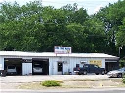

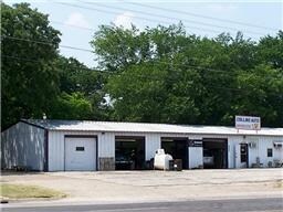
Property Detail
2023 E Henderson St
Dallas-Fort Worth-Arlington, TX
ABST 477 TR 1 D KING 126.5528.99333,.6628.94466, 6628.94471 .6628.94470
126-0477-00290
JOHNSON
Commercialnec
Texas
B and X Area of moderate flood hazard, usually the area between the limits of the 100-year and 500-year floods.
09
2024
4.80 AC
2025
Southwest Outlying
130304
Dallas/Ft Worth
3,000 SF
NEARBY LISTINGS FOR SALE OR LEASE
DEMOGRAPHICS near 2023 E Henderson St
1 mile
3 mile
5 mile
2025 Total Population
976
25,408
51,536
2030 Population
1,134
29,107
58,765
Pop Growth 2025-2030
+ 16.19%
+ 14.56%
+ 14.03%
Average Age
42
37
38
2025 Total Households
381
8,375
17,970
HH Growth 2025-2030
+ 16.01%
+ 14.33%
+ 13.70%
Median Household Inc
$57,999
$58,290
$66,242
Avg Household Size
2.60
2.80
2.70
2025 Avg HH Vehicles
2.00
2.00
2.00
Median Home Value
$249,295
$212,223
$241,229
Median Year Built
1992
1984
1984
Nearby Places
Map Layers
Map Styles
 Street
 Aerial
Transit
 Traffic
 Biking
Places
Listings with unknown addresses are not visible on the map
- Restaurants
- Banks
- Shops
- Fitness
- Groceries
PUBLIC TRANSPORTATION
COMMUTER RAIL
Cleburne Amtrak Station (Texas Eagle - Amtrak)
Drive
Walk
Distance
Cleburne Amtrak Station (Texas Eagle - Amtrak)
5 min
2.8 mi
Freight Ports
Port of Shreveport
Drive
Walk
Distance
Port of Shreveport
257 min
237.3 mi
Nearby Properties
Address
Land Use
TOTAL SIZE
Lot Size
Zoning
Address
Land Use
TOTAL SIZE
Lot Size
Zoning
24.31 AC
Address
Land Use
TOTAL SIZE
Lot Size
Zoning
11,176 SF
0.08 AC
Address
Land Use
TOTAL SIZE
Lot Size
Zoning
127,936 SF
41.41 AC
Address
Land Use
TOTAL SIZE
Lot Size
Zoning
81,253 SF
3.51 AC
Address
Land Use
TOTAL SIZE
Lot Size
Zoning
11.04 AC
Address
Land Use
TOTAL SIZE
Lot Size
Zoning
1.01 AC
Address
Land Use
TOTAL SIZE
Lot Size
Zoning
69,592 SF
29.56 AC
Address
Land Use
TOTAL SIZE
Lot Size
Zoning
74,275 SF
23.13 AC
Address
Land Use
TOTAL SIZE
Lot Size
Zoning
67,699 SF
43.74 AC
Address
Land Use
TOTAL SIZE
Lot Size
Zoning
67,564 SF
11 AC
Address
Land Use
TOTAL SIZE
Lot Size
Zoning
24.44 AC
Address
Land Use
TOTAL SIZE
Lot Size
Zoning
668,640 SF
0.08 AC
Address
Land Use
TOTAL SIZE
Lot Size
Zoning
1 SF
35.23 AC
Address
Land Use
TOTAL SIZE
Lot Size
Zoning
90.80 AC
Address
Land Use
TOTAL SIZE
Lot Size
Zoning
12,000 SF
5.54 AC
Address
Land Use
TOTAL SIZE
Lot Size
Zoning
68,230 SF
8.15 AC
Address
Land Use
TOTAL SIZE
Lot Size
Zoning
143,327 SF
20 AC
Address
Land Use
TOTAL SIZE
Lot Size
Zoning
129,408 SF
16.72 AC
Address
Land Use
TOTAL SIZE
Lot Size
Zoning
29,553 SF
7.93 AC
Address
Land Use
TOTAL SIZE
Lot Size
Zoning
82,669 SF
11.50 AC
Address
Land Use
TOTAL SIZE
Lot Size
Zoning
43,070 SF
7.57 AC
Address
Land Use
TOTAL SIZE
Lot Size
Zoning
3.74 AC
Address
Land Use
TOTAL SIZE
Lot Size
Zoning
34,500 SF
1.44 AC
Address
Land Use
TOTAL SIZE
Lot Size
Zoning
109,045 SF
12.09 AC
Address
Land Use
TOTAL SIZE
Lot Size
Zoning
61,336 SF
10.30 AC
Address
Land Use
TOTAL SIZE
Lot Size
Zoning
43,000 SF
23.50 AC
Address
Land Use
TOTAL SIZE
Lot Size
Zoning
44,992 SF
18.14 AC
Address
Land Use
TOTAL SIZE
Lot Size
Zoning
47,300 SF
14.67 AC
Address
Land Use
TOTAL SIZE
Lot Size
Zoning
0.52 AC
Address
Land Use
TOTAL SIZE
Lot Size
Zoning
23,863 SF
13.53 AC
The World's #1 Commercial Real Estate Marketplace
Connect with us
© 2026 CoStar Group
The information above has been obtained from sources believed reliable. While we do not doubt its accuracy we have not verified it and make no guarantee, warranty or representation about it. It is your responsibility to independently confirm its accuracy and completeness. Any projections, opinions, assumptions, or estimates used are for example only and do not represent the current or future performance of the property. The value of this transaction to you depends on tax and other factors which should be evaluated by your tax, financial, and legal advisors. You and your advisors should conduct a careful, independent investigation of the property to determine to your satisfaction the suitability of the property for your needs.