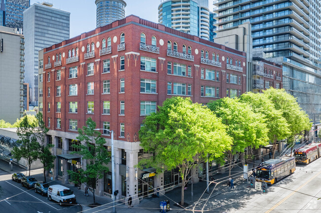
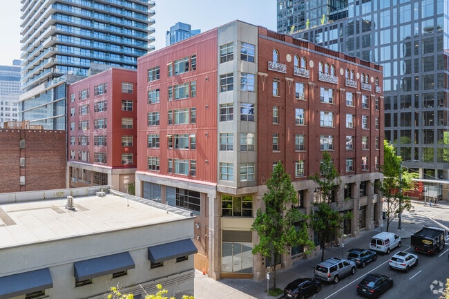
Property Record
2024 3Rd Ave, Seattle, WA 98121


NEARBY LISTINGS FOR SALE OR LEASE
Property Detail
2024 3Rd Ave
872969-0020
2024 Third Ave
Transientlodging
2024 THIRD AVE CONDOMINIUM PCT UND INT 62.50
X
King
53033C0630G
Washington
2021
0.44 AC
2024
Downtown Seattle
007202
Seattle/Puget Sound
94,880 SF
Seattle-Tacoma-Bellevue, WA
DEMOGRAPHICS near 2024 3Rd Ave
1 Mile
3 Mile
5 Mile
2024 Total Population
84,155
263,637
502,410
2029 Population
86,801
269,759
511,124
Pop Growth 2024-2029
+ 3.14%
+ 2.32%
+ 1.73%
Average Age
38
38
38
2024 Total Households
54,381
145,049
251,097
HH Growth 2024-2029
+ 3.10%
+ 2.34%
+ 1.82%
Median Household Inc
$114,207
$113,044
$115,632
Avg Household Size
1.40
1.70
1.90
2024 Avg HH Vehicles
1.00
1.00
1.00
Median Home Value
$860,574
$980,836
$944,704
Median Year Built
2004
1990
1983
Nearby Places
Map Layers
Map Styles
 Street
 Aerial
- Restaurants
- Banks
- Shops
- Fitness
- Groceries
PUBLIC TRANSPORTATION
TRANSIT/SUBWAY
Westlake Ave & Olive Way (South Lake Union Streetcar - Seattle Streetcar)
DRIVE
WALK
Distance
Westlake Ave & Olive Way (South Lake Union Streetcar - Seattle Streetcar)
1 min
5 min
0.3 mi
Westlake Ave & Olive Way (South Lake Union Streetcar - Seattle Streetcar)
DRIVE
WALK
Distance
Westlake Ave & Olive Way (South Lake Union Streetcar - Seattle Streetcar)
2 min
5 min
0.3 mi
Westlake Ave & Virginia St (South Lake Union Streetcar - Seattle Streetcar)
DRIVE
WALK
Distance
Westlake Ave & Virginia St (South Lake Union Streetcar - Seattle Streetcar)
1 min
5 min
0.3 mi
Westlake Hub (South Lake Union Streetcar - Seattle Streetcar)
DRIVE
WALK
Distance
Westlake Hub (South Lake Union Streetcar - Seattle Streetcar)
2 min
5 min
0.3 mi
Westlake Center (Seattle Center Monorail - Seattle Monorail Services (Seattle Monorail))
DRIVE
WALK
Distance
Westlake Center (Seattle Center Monorail - Seattle Monorail Services (Seattle Monorail))
2 min
5 min
0.3 mi
COMMUTER RAIL
King Street (Seattle) Station (Sounder South Line - Central Puget Sound Regional Transit Authority Rail (Link Light Rail/Sounder))
DRIVE
WALK
Distance
King Street (Seattle) Station (Sounder South Line - Central Puget Sound Regional Transit Authority Rail (Link Light Rail/Sounder))
6 min
1.3 mi
AIRPORT
Seattle-Tacoma International
DRIVE
WALK
Distance
Seattle-Tacoma International
19 min
14.4 mi
Freight Ports
Port of Seattle
DRIVE
WALK
Distance
Port of Seattle
1 min
3.0 mi
Nearby Properties
Address
Land Use
TOTAL SIZE
Lot Size
Zoning
Address
Land Use
TOTAL SIZE
Lot Size
Zoning
800,000 SF
8.57 AC
SM-UP 95 (
Address
Land Use
TOTAL SIZE
Lot Size
Zoning
471.20 AC
MIO-37-LR1
Address
Land Use
TOTAL SIZE
Lot Size
Zoning
2.84 AC
DMC 340/29
Address
Land Use
TOTAL SIZE
Lot Size
Zoning
793,990 SF
30.81 AC
UI U/85
Address
Land Use
TOTAL SIZE
Lot Size
Zoning
946,212 SF
1.58 AC
DMC 340/29
Address
Land Use
TOTAL SIZE
Lot Size
Zoning
686,722 SF
1.26 AC
SM-SLU 240
Address
Land Use
TOTAL SIZE
Lot Size
Zoning
36,864 SF
8.02 AC
SM-UP 95 (
Address
Land Use
TOTAL SIZE
Lot Size
Zoning
992,925 SF
4.28 AC
MIO-240-HR
Address
Land Use
TOTAL SIZE
Lot Size
Zoning
1,526,621 SF
1.36 AC
DOC1 U/450
Address
Land Use
TOTAL SIZE
Lot Size
Zoning
716,128 SF
1.41 AC
SM-SLU 175
Address
Land Use
TOTAL SIZE
Lot Size
Zoning
1,062,251 SF
1.47 AC
DOC2 500/3
Address
Land Use
TOTAL SIZE
Lot Size
Zoning
763,898 SF
2.03 AC
DOC2 500/3
Address
Land Use
TOTAL SIZE
Lot Size
Zoning
1,137,666 SF
2.07 AC
DOC1 U/450
Address
Land Use
TOTAL SIZE
Lot Size
Zoning
7,930 SF
4.14 AC
MIO-240-HR
Address
Land Use
TOTAL SIZE
Lot Size
Zoning
6,379 SF
127.60 AC
MML U/85
Address
Land Use
TOTAL SIZE
Lot Size
Zoning
1,128,575 SF
1.30 AC
DOC1 U/450
Address
Land Use
TOTAL SIZE
Lot Size
Zoning
615,000 SF
0.88 AC
DOC2 500/3
Address
Land Use
TOTAL SIZE
Lot Size
Zoning
861,221 SF
1.30 AC
DMC 340/29
Address
Land Use
TOTAL SIZE
Lot Size
Zoning
565,110 SF
29.11 AC
II U/85
Address
Land Use
TOTAL SIZE
Lot Size
Zoning
377,813 SF
1.65 AC
DOC2 500/3
Address
Land Use
TOTAL SIZE
Lot Size
Zoning
1,011,547 SF
0.35 AC
DOC1 U/450
Address
Land Use
TOTAL SIZE
Lot Size
Zoning
1,478,612 SF
0.80 AC
DOC2 500/3
Address
Land Use
TOTAL SIZE
Lot Size
Zoning
67,235 SF
0.45 AC
DOC2 500/3
Address
Land Use
TOTAL SIZE
Lot Size
Zoning
922,344 SF
1.33 AC
DRC 85-170
Address
Land Use
TOTAL SIZE
Lot Size
Zoning
413,982 SF
0.58 AC
DMC 340/29
Address
Land Use
TOTAL SIZE
Lot Size
Zoning
412,000 SF
1.27 AC
DOC1 U/450
Address
Land Use
TOTAL SIZE
Lot Size
Zoning
943,610 SF
1.24 AC
DOC1 U/450
Address
Land Use
TOTAL SIZE
Lot Size
Zoning
155,795 SF
7.89 AC
SM-UP 95 (
The World's #1 Commercial Real Estate Marketplace
Connect with us
© 2026 CoStar Group
The information above has been obtained from sources believed reliable. While we do not doubt its accuracy we have not verified it and make no guarantee, warranty or representation about it. It is your responsibility to independently confirm its accuracy and completeness. Any projections, opinions, assumptions, or estimates used are for example only and do not represent the current or future performance of the property. The value of this transaction to you depends on tax and other factors which should be evaluated by your tax, financial, and legal advisors. You and your advisors should conduct a careful, independent investigation of the property to determine to your satisfaction the suitability of the property for your needs.