Property Record
2025 E Graves Ave, Orange City, FL 32763


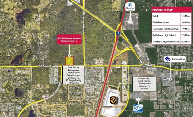
This Property Is For Sale
NEARBY LISTINGS FOR SALE OR LEASE
-
-
-
-
-
-
-
East Rhode Island Avenue @ Veterans Memorial Hwy
Orange City, FL 32763
$11,500,000
42.92 AC Lots
Land
-
-
-
-
-
-
-
-
-
View all Orange City listings for sale on LoopNet.com
Property Detail
2025 E Graves Ave
Deltona-Daytona Beach-Ormond Beach, FL
Acreage
8001-00-00-0290
Volusia
Sfr
Florida
X
8.86 AC
12127C0610J
Deltona
2,310 SF
Deltona/Daytona Beach
DEMOGRAPHICS near 2025 E Graves Ave
1 Mile
3 Mile
5 Mile
2024 Total Population
2,359
41,371
112,903
2029 Population
2,545
45,792
124,260
Pop Growth 2024-2029
+ 7.88%
+ 10.69%
+ 10.06%
Average Age
55
43
42
2024 Total Households
1,168
16,312
43,191
HH Growth 2024-2029
+ 7.62%
+ 10.79%
+ 10.19%
Median Household Inc
$56,472
$65,127
$64,914
Avg Household Size
1.90
2.50
2.50
2024 Avg HH Vehicles
1.00
2.00
2.00
Median Home Value
$226,546
$240,735
$236,283
Median Year Built
1985
1990
1989
Nearby Places
Map Layers
Map Styles
 Street
 Aerial
- Restaurants
- Banks
- Shops
- Fitness
- Groceries
PUBLIC TRANSPORTATION
COMMUTER RAIL
Deland (Silver Meteor - Amtrak, Silver Star - Amtrak, SunRail - Amtrak)
DRIVE
WALK
Distance
Deland (Silver Meteor - Amtrak, Silver Star - Amtrak, SunRail - Amtrak)
16 min
9.1 mi
AIRPORT
Orlando Sanford International
DRIVE
WALK
Distance
Orlando Sanford International
32 min
20.7 mi
Daytona Beach International
DRIVE
WALK
Distance
Daytona Beach International
30 min
23.0 mi
Freight Ports
Port Canaveral
DRIVE
WALK
Distance
Port Canaveral
93 min
78.1 mi
Nearby Properties
Address
Land Use
TOTAL SIZE
Lot Size
Zoning
Address
Land Use
TOTAL SIZE
Lot Size
Zoning
485,392 SF
69.83 AC
ROW
Address
Land Use
TOTAL SIZE
Lot Size
Zoning
986,415 SF
56.11 AC
Address
Land Use
TOTAL SIZE
Lot Size
Zoning
1,337,979 SF
85.14 AC
01I2
Address
Land Use
TOTAL SIZE
Lot Size
Zoning
204,239 SF
31.36 AC
Address
Land Use
TOTAL SIZE
Lot Size
Zoning
423,073 SF
12.48 AC
Address
Land Use
TOTAL SIZE
Lot Size
Zoning
689,978 SF
39.89 AC
RRC
Address
Land Use
TOTAL SIZE
Lot Size
Zoning
369,949 SF
13.70 AC
Address
Land Use
TOTAL SIZE
Lot Size
Zoning
390,347 SF
4.10 AC
Address
Land Use
TOTAL SIZE
Lot Size
Zoning
352,859 SF
16 AC
R4C2
Address
Land Use
TOTAL SIZE
Lot Size
Zoning
299,423 SF
88.63 AC
12R1
Address
Land Use
TOTAL SIZE
Lot Size
Zoning
255,327 SF
28.64 AC
Address
Land Use
TOTAL SIZE
Lot Size
Zoning
339,508 SF
72.75 AC
01A3
Address
Land Use
TOTAL SIZE
Lot Size
Zoning
350,763 SF
60 AC
12R1
Address
Land Use
TOTAL SIZE
Lot Size
Zoning
221,429 SF
25.84 AC
Address
Land Use
TOTAL SIZE
Lot Size
Zoning
136,761 SF
17.77 AC
Address
Land Use
TOTAL SIZE
Lot Size
Zoning
121,380 SF
2.33 AC
Address
Land Use
TOTAL SIZE
Lot Size
Zoning
50,005 SF
5.60 AC
Address
Land Use
TOTAL SIZE
Lot Size
Zoning
312,508 SF
28.68 AC
05C2
Address
Land Use
TOTAL SIZE
Lot Size
Zoning
170,850 SF
17.82 AC
Address
Land Use
TOTAL SIZE
Lot Size
Zoning
33,371 SF
12.86 AC
Address
Land Use
TOTAL SIZE
Lot Size
Zoning
213,506 SF
21 AC
12R2
Address
Land Use
TOTAL SIZE
Lot Size
Zoning
5,195 SF
55.08 AC
A3
Address
Land Use
TOTAL SIZE
Lot Size
Zoning
4,684 SF
1.14 AC
12MH1
Address
Land Use
TOTAL SIZE
Lot Size
Zoning
117,406 SF
17.58 AC
Address
Land Use
TOTAL SIZE
Lot Size
Zoning
9,421 SF
7 AC
Address
Land Use
TOTAL SIZE
Lot Size
Zoning
147,759 SF
19.64 AC
Address
Land Use
TOTAL SIZE
Lot Size
Zoning
214,666 SF
9 AC
Address
Land Use
TOTAL SIZE
Lot Size
Zoning
115,271 SF
17.08 AC
R4
Address
Land Use
TOTAL SIZE
Lot Size
Zoning
28.62 AC
01A1
Address
Land Use
TOTAL SIZE
Lot Size
Zoning
127,891 SF
10.58 AC
The World's #1 Commercial Real Estate Marketplace
Connect with us
© 2026 CoStar Group
The information above has been obtained from sources believed reliable. While we do not doubt its accuracy we have not verified it and make no guarantee, warranty or representation about it. It is your responsibility to independently confirm its accuracy and completeness. Any projections, opinions, assumptions, or estimates used are for example only and do not represent the current or future performance of the property. The value of this transaction to you depends on tax and other factors which should be evaluated by your tax, financial, and legal advisors. You and your advisors should conduct a careful, independent investigation of the property to determine to your satisfaction the suitability of the property for your needs.