Property Record
2025 E Kerr St, Springfield, MO 65803
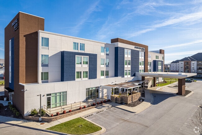

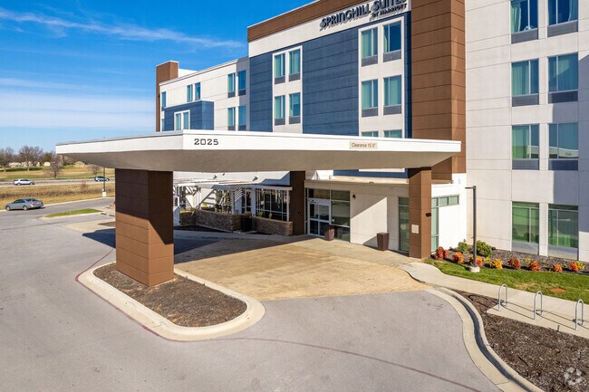
Property Detail
2025 E Kerr St
Springfield, MO
KERR AND BARNES PHASE II LOT 2
88-12-05-218-035
GREENE
Hotel
Missouri
INC
2
B and X Area of moderate flood hazard, usually the area between the limits of the 100-year and 500-year floods.
2.75 AC
2025
Springfield
2025
Springfield
002200
NEARBY LISTINGS FOR SALE OR LEASE
-
-
View all Springfield listings for sale on LoopNet.com
DEMOGRAPHICS near 2025 E Kerr St
1 mile
3 mile
5 mile
2025 Total Population
4,403
37,061
106,345
2030 Population
4,499
38,133
109,626
Pop Growth 2025-2030
+ 2.18%
+ 2.89%
+ 3.09%
Average Age
38
38
37
2025 Total Households
2,111
15,066
45,998
HH Growth 2025-2030
+ 2.32%
+ 3.10%
+ 3.31%
Median Household Inc
$50,636
$47,468
$47,099
Avg Household Size
2.00
2.20
2.10
2025 Avg HH Vehicles
2.00
2.00
2.00
Median Home Value
$157,682
$165,497
$189,782
Median Year Built
1983
1973
1973
Nearby Places
Map Layers
Map Styles
 Street
 Aerial
Layers
 Traffic
 Biking
Places
Listings with unknown addresses are not visible on the map
- Restaurants
- Banks
- Shops
- Fitness
- Groceries
PUBLIC TRANSPORTATION
AIRPORT
Springfield-Branson Ntl
Drive
Walk
Distance
Springfield-Branson Ntl
22 min
12.0 mi
SALE & LEASE HISTORY
LISTING DATE
SALE/LEASE

Jun 03, 2021
For Sale
Nearby Properties
Address
Land Use
TOTAL SIZE
Lot Size
Zoning
Address
Land Use
TOTAL SIZE
Lot Size
Zoning
11.54 AC
Address
Land Use
TOTAL SIZE
Lot Size
Zoning
35.56 AC
INC
Address
Land Use
TOTAL SIZE
Lot Size
Zoning
617,990 SF
49.88 AC
INC
Address
Land Use
TOTAL SIZE
Lot Size
Zoning
343,758 SF
29.81 AC
INC
Address
Land Use
TOTAL SIZE
Lot Size
Zoning
22.01 AC
INC.
Address
Land Use
TOTAL SIZE
Lot Size
Zoning
1,728,457 SF
123.60 AC
INC
Address
Land Use
TOTAL SIZE
Lot Size
Zoning
340,000 SF
37.93 AC
INC
Address
Land Use
TOTAL SIZE
Lot Size
Zoning
359,020 SF
14 AC
INC
Address
Land Use
TOTAL SIZE
Lot Size
Zoning
37.01 AC
INC
Address
Land Use
TOTAL SIZE
Lot Size
Zoning
349,216 SF
29.46 AC
INC
Address
Land Use
TOTAL SIZE
Lot Size
Zoning
5.84 AC
INC
Address
Land Use
TOTAL SIZE
Lot Size
Zoning
805,370 SF
54.30 AC
INC
Address
Land Use
TOTAL SIZE
Lot Size
Zoning
24.54 AC
INC.
Address
Land Use
TOTAL SIZE
Lot Size
Zoning
13.88 AC
INC
Address
Land Use
TOTAL SIZE
Lot Size
Zoning
1,825 SF
4.31 AC
INC
Address
Land Use
TOTAL SIZE
Lot Size
Zoning
5.47 AC
INC
Address
Land Use
TOTAL SIZE
Lot Size
Zoning
143,774 SF
5.85 AC
INC
Address
Land Use
TOTAL SIZE
Lot Size
Zoning
108,153 SF
7.37 AC
INC.
Address
Land Use
TOTAL SIZE
Lot Size
Zoning
290,844 SF
20.78 AC
INC
Address
Land Use
TOTAL SIZE
Lot Size
Zoning
127,740 SF
27.70 AC
INC
Address
Land Use
TOTAL SIZE
Lot Size
Zoning
92,702 SF
42.54 AC
INC
Address
Land Use
TOTAL SIZE
Lot Size
Zoning
20.11 AC
INC
Address
Land Use
TOTAL SIZE
Lot Size
Zoning
110,347 SF
14.58 AC
INC
Address
Land Use
TOTAL SIZE
Lot Size
Zoning
16.73 AC
Address
Land Use
TOTAL SIZE
Lot Size
Zoning
256,172 SF
19.03 AC
INC
Address
Land Use
TOTAL SIZE
Lot Size
Zoning
79.50 AC
INC
Address
Land Use
TOTAL SIZE
Lot Size
Zoning
4.62 AC
INC
Address
Land Use
TOTAL SIZE
Lot Size
Zoning
328,252 SF
18.67 AC
INC
Address
Land Use
TOTAL SIZE
Lot Size
Zoning
32.40 AC
INC
The World's #1 Commercial Real Estate Marketplace
Connect with us
© 2026 CoStar Group
The information above has been obtained from sources believed reliable. While we do not doubt its accuracy we have not verified it and make no guarantee, warranty or representation about it. It is your responsibility to independently confirm its accuracy and completeness. Any projections, opinions, assumptions, or estimates used are for example only and do not represent the current or future performance of the property. The value of this transaction to you depends on tax and other factors which should be evaluated by your tax, financial, and legal advisors. You and your advisors should conduct a careful, independent investigation of the property to determine to your satisfaction the suitability of the property for your needs.