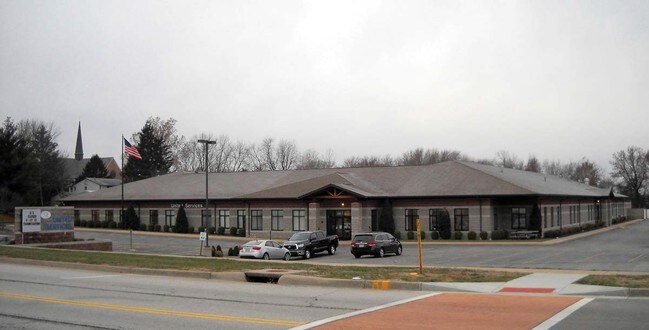
Property Record
2025 Hanley Rd, O Fallon, MO 63368

Save to a Folder
{{folder.Name}}
{{folder.ListingIds.length}} Properties
{{folder.ListingIds.length}} Property
Create a New Folder
Property Detail
2025 Hanley Rd
4-0033-4052-03-0001.0000000
KIMBERLY AC BLK 3 LOT 1
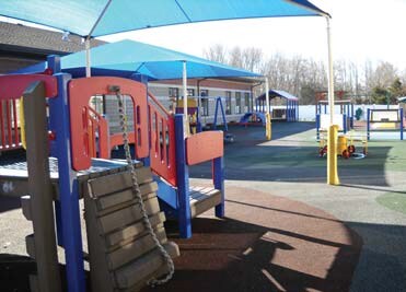
Publicschool
ST. CHARLES
AF0
Missouri
B and X Area of moderate flood hazard, usually the area between the limits of the 100-year and 500-year floods.
1
0
6.10 AC
2025
St Charles County
311904
St. Louis
36,607 SF
St. Louis, MO-IL
NEARBY LISTINGS FOR SALE OR LEASE
-
-
View all O Fallon listings for sale on LoopNet.com
DEMOGRAPHICS near 2025 Hanley Rd
1 mile
3 mile
5 mile
2025 Total Population
9,924
74,994
144,941
2030 Population
10,479
78,246
151,058
Pop Growth 2025-2030
+ 5.59%
+ 4.34%
+ 4.22%
Average Age
40
40
40
2025 Total Households
3,757
27,663
52,891
HH Growth 2025-2030
+ 5.72%
+ 4.52%
+ 4.40%
Median Household Inc
$115,843
$111,933
$113,922
Avg Household Size
2.60
2.70
2.70
2025 Avg HH Vehicles
2.00
2.00
2.00
Median Home Value
$387,564
$358,937
$353,834
Median Year Built
2005
2001
2000
Nearby Places
Map Layers
Map Styles
 Street
 Aerial
Layers
 Traffic
 Biking
Places
Listings with unknown addresses are not visible on the map
- Restaurants
- Banks
- Shops
- Fitness
- Groceries
PUBLIC TRANSPORTATION
AIRPORT
St Louis Lambert International
Drive
Walk
Distance
St Louis Lambert International
38 min
26.4 mi
Freight Ports
Tulsa Port of Inola
Drive
Walk
Distance
Tulsa Port of Inola
427 min
378.0 mi
Nearby Properties
Address
Land Use
TOTAL SIZE
Lot Size
Zoning
Address
Land Use
TOTAL SIZE
Lot Size
Zoning
482.60 AC
AC7
Address
Land Use
TOTAL SIZE
Lot Size
Zoning
163,438 SF
5.76 AC
Address
Land Use
TOTAL SIZE
Lot Size
Zoning
537,735 SF
39.93 AC
Address
Land Use
TOTAL SIZE
Lot Size
Zoning
82,169 SF
25.78 AC
Address
Land Use
TOTAL SIZE
Lot Size
Zoning
256,858 SF
20.03 AC
Address
Land Use
TOTAL SIZE
Lot Size
Zoning
67,680 SF
7.08 AC
Address
Land Use
TOTAL SIZE
Lot Size
Zoning
420,705 SF
37.21 AC
Address
Land Use
TOTAL SIZE
Lot Size
Zoning
244,087 SF
7.24 AC
Address
Land Use
TOTAL SIZE
Lot Size
Zoning
Address
Land Use
TOTAL SIZE
Lot Size
Zoning
254,435 SF
16.57 AC
Address
Land Use
TOTAL SIZE
Lot Size
Zoning
44,952 SF
19.67 AC
Address
Land Use
TOTAL SIZE
Lot Size
Zoning
Address
Land Use
TOTAL SIZE
Lot Size
Zoning
261,357 SF
7.90 AC
Address
Land Use
TOTAL SIZE
Lot Size
Zoning
209,627 SF
10.38 AC
Address
Land Use
TOTAL SIZE
Lot Size
Zoning
176,189 SF
5.80 AC
Address
Land Use
TOTAL SIZE
Lot Size
Zoning
35,670 SF
1.12 AC
Address
Land Use
TOTAL SIZE
Lot Size
Zoning
16,560 SF
4.36 AC
Address
Land Use
TOTAL SIZE
Lot Size
Zoning
77.65 AC
AC7
Address
Land Use
TOTAL SIZE
Lot Size
Zoning
35,112 SF
0.88 AC
Address
Land Use
TOTAL SIZE
Lot Size
Zoning
49,680 SF
2.22 AC
Address
Land Use
TOTAL SIZE
Lot Size
Zoning
161,427 SF
8.80 AC
Address
Land Use
TOTAL SIZE
Lot Size
Zoning
251,169 SF
20.19 AC
Address
Land Use
TOTAL SIZE
Lot Size
Zoning
7,793 SF
26.43 AC
Address
Land Use
TOTAL SIZE
Lot Size
Zoning
111,573 SF
19.11 AC
Address
Land Use
TOTAL SIZE
Lot Size
Zoning
210,095 SF
12.29 AC
AE9
Address
Land Use
TOTAL SIZE
Lot Size
Zoning
140,826 SF
7.09 AC
Address
Land Use
TOTAL SIZE
Lot Size
Zoning
66,782 SF
6.72 AC
Address
Land Use
TOTAL SIZE
Lot Size
Zoning
218,526 SF
21.26 AC
Address
Land Use
TOTAL SIZE
Lot Size
Zoning
183,416 SF
40.46 AC
The World's #1 Commercial Real Estate Marketplace
Connect with us
© 2026 CoStar Group
The information above has been obtained from sources believed reliable. While we do not doubt its accuracy we have not verified it and make no guarantee, warranty or representation about it. It is your responsibility to independently confirm its accuracy and completeness. Any projections, opinions, assumptions, or estimates used are for example only and do not represent the current or future performance of the property. The value of this transaction to you depends on tax and other factors which should be evaluated by your tax, financial, and legal advisors. You and your advisors should conduct a careful, independent investigation of the property to determine to your satisfaction the suitability of the property for your needs.