Property Record
2025 Mclarty Dr, Newport, AR 72112
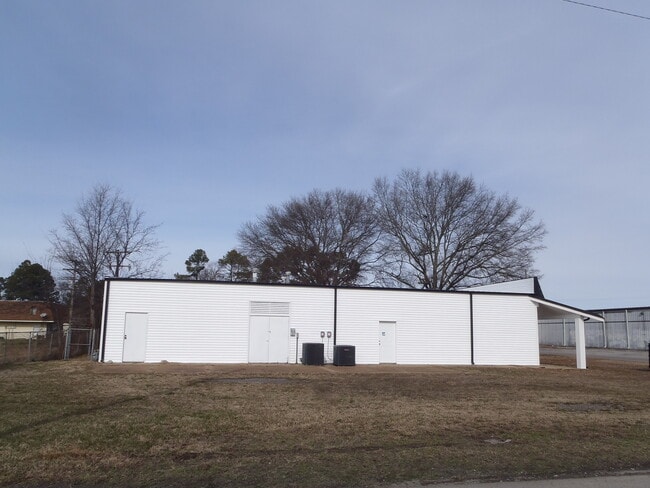


This Property Is For Sale
Property Detail
2025 Mclarty Dr
013-03272-000
TRACT A: A PARCEL OF LAND 115.0 FEET EAST AND WEST BY 120.06 FEET NORTH AND SOUTH, BEING TRACT A AS SHOWN ON THE PLAT OF VILL
Radioortvstationcommunications
JACKSON
AE The base floodplain where base flood elevations are provided. AE Zones are now used on new format FIRMs instead of A1-A30 Zones.
Arkansas
2025
0.39 AC
2025
Arkansas North Area
480300
Other Market Areas
3,570 SF
NEARBY LISTINGS FOR SALE OR LEASE
-
-
View all Newport listings for sale on LoopNet.com
DEMOGRAPHICS near 2025 Mclarty Dr
1 mile
3 mile
5 mile
2025 Total Population
3,305
7,272
9,285
2030 Population
3,252
7,216
9,206
Pop Growth 2025-2030
(1.60%)
(0.77%)
(0.85%)
Average Age
42
41
41
2025 Total Households
1,459
3,067
3,580
HH Growth 2025-2030
(1.78%)
(0.82%)
(0.98%)
Median Household Inc
$31,139
$32,706
$34,332
Avg Household Size
2.20
2.20
2.20
2025 Avg HH Vehicles
2.00
2.00
2.00
Median Home Value
$146,822
$124,300
$111,650
Median Year Built
1973
1971
1972
Nearby Places
Map Layers
Map Styles
 Street
 Aerial
Layers
 Traffic
 Biking
Places
Listings with unknown addresses are not visible on the map
- Restaurants
- Banks
- Shops
- Fitness
- Groceries
Nearby Properties
Address
Land Use
TOTAL SIZE
Lot Size
Zoning
Address
Land Use
TOTAL SIZE
Lot Size
Zoning
12,500 SF
63.47 AC
Address
Land Use
TOTAL SIZE
Lot Size
Zoning
125,484 SF
32.93 AC
Address
Land Use
TOTAL SIZE
Lot Size
Zoning
31,722 SF
1.55 AC
Address
Land Use
TOTAL SIZE
Lot Size
Zoning
14,338 SF
5.39 AC
Address
Land Use
TOTAL SIZE
Lot Size
Zoning
69,430 SF
6.48 AC
Address
Land Use
TOTAL SIZE
Lot Size
Zoning
24,524 SF
4.72 AC
Address
Land Use
TOTAL SIZE
Lot Size
Zoning
42,980 SF
20 AC
Address
Land Use
TOTAL SIZE
Lot Size
Zoning
34,111 SF
5 AC
Address
Land Use
TOTAL SIZE
Lot Size
Zoning
43,155 SF
5.31 AC
Address
Land Use
TOTAL SIZE
Lot Size
Zoning
25,870 SF
3.67 AC
Address
Land Use
TOTAL SIZE
Lot Size
Zoning
3,120 SF
13.68 AC
Address
Land Use
TOTAL SIZE
Lot Size
Zoning
189,172 SF
48.08 AC
Address
Land Use
TOTAL SIZE
Lot Size
Zoning
26,784 SF
5.77 AC
Address
Land Use
TOTAL SIZE
Lot Size
Zoning
26,955 SF
5 AC
Address
Land Use
TOTAL SIZE
Lot Size
Zoning
6,612 SF
0.91 AC
Address
Land Use
TOTAL SIZE
Lot Size
Zoning
21,724 SF
4.92 AC
Address
Land Use
TOTAL SIZE
Lot Size
Zoning
14,400 SF
8.69 AC
Address
Land Use
TOTAL SIZE
Lot Size
Zoning
30,453 SF
4.61 AC
Address
Land Use
TOTAL SIZE
Lot Size
Zoning
102,810 SF
10.30 AC
Address
Land Use
TOTAL SIZE
Lot Size
Zoning
8,100 SF
7.52 AC
Address
Land Use
TOTAL SIZE
Lot Size
Zoning
21,150 SF
3.47 AC
Address
Land Use
TOTAL SIZE
Lot Size
Zoning
1,760 SF
24.90 AC
Address
Land Use
TOTAL SIZE
Lot Size
Zoning
18,284 SF
1.80 AC
Address
Land Use
TOTAL SIZE
Lot Size
Zoning
46,162 SF
3.58 AC
Address
Land Use
TOTAL SIZE
Lot Size
Zoning
12,460 SF
2.13 AC
Address
Land Use
TOTAL SIZE
Lot Size
Zoning
13,166 SF
1.34 AC
Address
Land Use
TOTAL SIZE
Lot Size
Zoning
11,429 SF
0.33 AC
Address
Land Use
TOTAL SIZE
Lot Size
Zoning
9,732 SF
11.66 AC
Address
Land Use
TOTAL SIZE
Lot Size
Zoning
19,957 SF
5.42 AC
Address
Land Use
TOTAL SIZE
Lot Size
Zoning
4,929 SF
3.61 AC
The World's #1 Commercial Real Estate Marketplace
Connect with us
© 2026 CoStar Group
The information above has been obtained from sources believed reliable. While we do not doubt its accuracy we have not verified it and make no guarantee, warranty or representation about it. It is your responsibility to independently confirm its accuracy and completeness. Any projections, opinions, assumptions, or estimates used are for example only and do not represent the current or future performance of the property. The value of this transaction to you depends on tax and other factors which should be evaluated by your tax, financial, and legal advisors. You and your advisors should conduct a careful, independent investigation of the property to determine to your satisfaction the suitability of the property for your needs.