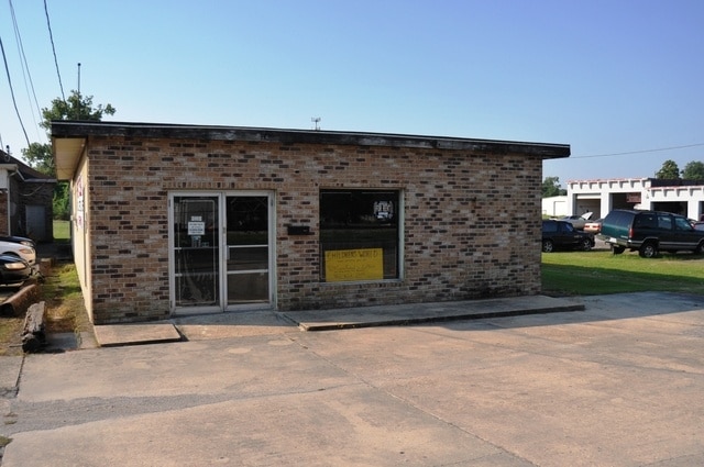
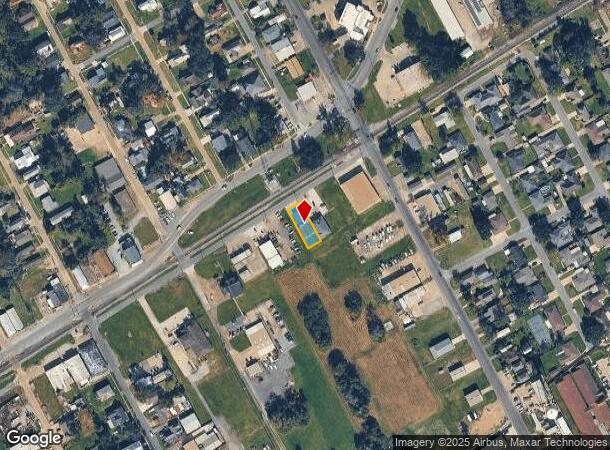
Property Record
2025 Railroad St, Lutcher, LA 70071

NEARBY LISTINGS FOR SALE OR LEASE
Property Detail
2025 Railroad St
New Orleans-Metairie, LA
Lutcher-Moore
200114990
LOT A-2-6 (50 X 150) IN L. & M. S/DIN SEC. 35 T. 12S. R. 5 E. (C H I L D R E NS W O R L D)BOOK 354 160 E.N. 10420SCHEXNAYDER
Officebuilding
St James
X
Louisiana
22093C0115C
a-2
2024
0.17 AC
2024
New Orleans Metairie/Airport
040200
Other Market Areas
DEMOGRAPHICS near 2025 Railroad St
1 Mile
3 Mile
5 Mile
2024 Total Population
3,914
9,877
13,486
2029 Population
3,594
9,239
12,566
Pop Growth 2024-2029
(8.18%)
(6.46%)
(6.82%)
Average Age
42
41
41
2024 Total Households
1,513
3,762
5,094
HH Growth 2024-2029
(7.93%)
(6.30%)
(6.69%)
Median Household Inc
$53,428
$58,725
$65,886
Avg Household Size
2.50
2.60
2.60
2024 Avg HH Vehicles
2.00
2.00
2.00
Median Home Value
$193,314
$216,685
$214,646
Median Year Built
1977
1982
1981
Nearby Places
Map Layers
Map Styles
 Street
 Aerial
- Restaurants
- Banks
- Shops
- Fitness
- Groceries
PUBLIC TRANSPORTATION
AIRPORT
Louis Armstrong New Orleans International
DRIVE
WALK
Distance
Louis Armstrong New Orleans International
43 min
31.4 mi
Freight Ports
Port of New Orleans
DRIVE
WALK
Distance
Port of New Orleans
64 min
46.0 mi
Nearby Properties
Address
Land Use
TOTAL SIZE
Lot Size
Zoning
Address
Land Use
TOTAL SIZE
Lot Size
Zoning
Address
Land Use
TOTAL SIZE
Lot Size
Zoning
1,132.37 AC
Address
Land Use
TOTAL SIZE
Lot Size
Zoning
148,425 SF
1.51 AC
Address
Land Use
TOTAL SIZE
Lot Size
Zoning
51,631 SF
10 AC
Address
Land Use
TOTAL SIZE
Lot Size
Zoning
21,935 SF
1.55 AC
Address
Land Use
TOTAL SIZE
Lot Size
Zoning
58,828 SF
9.21 AC
Address
Land Use
TOTAL SIZE
Lot Size
Zoning
Address
Land Use
TOTAL SIZE
Lot Size
Zoning
Address
Land Use
TOTAL SIZE
Lot Size
Zoning
Address
Land Use
TOTAL SIZE
Lot Size
Zoning
Address
Land Use
TOTAL SIZE
Lot Size
Zoning
Address
Land Use
TOTAL SIZE
Lot Size
Zoning
40,621 SF
71.94 AC
Address
Land Use
TOTAL SIZE
Lot Size
Zoning
44.90 AC
Address
Land Use
TOTAL SIZE
Lot Size
Zoning
38,423 SF
2 AC
Address
Land Use
TOTAL SIZE
Lot Size
Zoning
Address
Land Use
TOTAL SIZE
Lot Size
Zoning
Address
Land Use
TOTAL SIZE
Lot Size
Zoning
5.71 AC
Address
Land Use
TOTAL SIZE
Lot Size
Zoning
0.35 AC
Address
Land Use
TOTAL SIZE
Lot Size
Zoning
28.83 AC
Address
Land Use
TOTAL SIZE
Lot Size
Zoning
18,058 SF
0.69 AC
Address
Land Use
TOTAL SIZE
Lot Size
Zoning
Address
Land Use
TOTAL SIZE
Lot Size
Zoning
Address
Land Use
TOTAL SIZE
Lot Size
Zoning
6,753 SF
1.44 AC
Address
Land Use
TOTAL SIZE
Lot Size
Zoning
Address
Land Use
TOTAL SIZE
Lot Size
Zoning
216 SF
2.36 AC
Address
Land Use
TOTAL SIZE
Lot Size
Zoning
14,240 SF
1.57 AC
Address
Land Use
TOTAL SIZE
Lot Size
Zoning
1.54 AC
Address
Land Use
TOTAL SIZE
Lot Size
Zoning
The World's #1 Commercial Real Estate Marketplace
Connect with us
© 2025 CoStar Group
The information above has been obtained from sources believed reliable. While we do not doubt its accuracy we have not verified it and make no guarantee, warranty or representation about it. It is your responsibility to independently confirm its accuracy and completeness. Any projections, opinions, assumptions, or estimates used are for example only and do not represent the current or future performance of the property. The value of this transaction to you depends on tax and other factors which should be evaluated by your tax, financial, and legal advisors. You and your advisors should conduct a careful, independent investigation of the property to determine to your satisfaction the suitability of the property for your needs.