Property Record
2025 Westfield Ave, Waterloo, IA 50701

Save to a Folder
{{folder.Name}}
{{folder.ListingIds.length}} Properties
{{folder.ListingIds.length}} Property
Create a New Folder
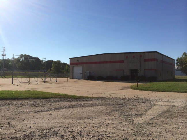
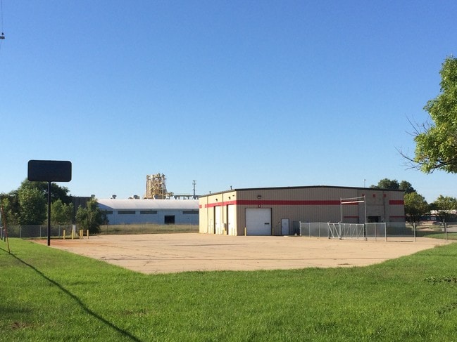
Property Detail
2025 Westfield Ave
8913-22-178-024
UNPLATTED WATERLOO WEST PART W 1/2 SEC 22 T 89 R 13 BEG AT A PT ON NE ROW LINE C R I & P RR 769.7 FT NW OF INTER OF N/S
Lightindustrial
Black Hawk
2025
Iowa
2025
2.70 AC
000400
Other Market Areas
6,400 SF
Waterloo-Cedar Falls, IA
NEARBY LISTINGS FOR SALE OR LEASE
DEMOGRAPHICS near 2025 Westfield Ave
1 mile
3 mile
5 mile
2025 Total Population
4,614
54,149
94,229
2030 Population
4,628
55,013
95,750
Pop Growth 2025-2030
+ 0.30%
+ 1.60%
+ 1.61%
Average Age
39
39
39
2025 Total Households
2,136
23,303
39,535
HH Growth 2025-2030
+ 0.28%
+ 1.68%
+ 1.68%
Median Household Inc
$54,006
$52,479
$56,224
Avg Household Size
2.10
2.20
2.20
2025 Avg HH Vehicles
2.00
2.00
2.00
Median Home Value
$134,294
$156,192
$171,490
Median Year Built
1956
1958
1962
Nearby Places
Map Layers
Map Styles
 Street
 Aerial
Layers
 Traffic
 Biking
Places
Listings with unknown addresses are not visible on the map
- Restaurants
- Banks
- Shops
- Fitness
- Groceries
Nearby Properties
Address
Land Use
TOTAL SIZE
Lot Size
Zoning
Address
Land Use
TOTAL SIZE
Lot Size
Zoning
528,634 SF
13.33 AC
Address
Land Use
TOTAL SIZE
Lot Size
Zoning
9,719 SF
42.81 AC
Address
Land Use
TOTAL SIZE
Lot Size
Zoning
108,671 SF
3.72 AC
Address
Land Use
TOTAL SIZE
Lot Size
Zoning
186,130 SF
10.89 AC
Address
Land Use
TOTAL SIZE
Lot Size
Zoning
622 SF
106.81 AC
Address
Land Use
TOTAL SIZE
Lot Size
Zoning
117,384 SF
19.56 AC
Address
Land Use
TOTAL SIZE
Lot Size
Zoning
341 SF
1.83 AC
Address
Land Use
TOTAL SIZE
Lot Size
Zoning
37,364 SF
10.78 AC
Address
Land Use
TOTAL SIZE
Lot Size
Zoning
101,633 SF
7 AC
Address
Land Use
TOTAL SIZE
Lot Size
Zoning
9,000 SF
21.25 AC
Address
Land Use
TOTAL SIZE
Lot Size
Zoning
59,565 SF
0.28 AC
Address
Land Use
TOTAL SIZE
Lot Size
Zoning
115,819 SF
2.07 AC
Address
Land Use
TOTAL SIZE
Lot Size
Zoning
129,863 SF
11.40 AC
Address
Land Use
TOTAL SIZE
Lot Size
Zoning
125,340 SF
0.80 AC
Address
Land Use
TOTAL SIZE
Lot Size
Zoning
1,600 SF
28.74 AC
Address
Land Use
TOTAL SIZE
Lot Size
Zoning
97,401 SF
21.83 AC
Address
Land Use
TOTAL SIZE
Lot Size
Zoning
60,496 SF
4.96 AC
Address
Land Use
TOTAL SIZE
Lot Size
Zoning
197,968 SF
6.10 AC
Address
Land Use
TOTAL SIZE
Lot Size
Zoning
41,999 SF
10.74 AC
Address
Land Use
TOTAL SIZE
Lot Size
Zoning
300 SF
46 AC
Address
Land Use
TOTAL SIZE
Lot Size
Zoning
70,933 SF
27.58 AC
Address
Land Use
TOTAL SIZE
Lot Size
Zoning
18,000 SF
141.74 AC
Address
Land Use
TOTAL SIZE
Lot Size
Zoning
1,600 SF
9.51 AC
Address
Land Use
TOTAL SIZE
Lot Size
Zoning
10,016 SF
16.22 AC
Address
Land Use
TOTAL SIZE
Lot Size
Zoning
10,016 SF
Address
Land Use
TOTAL SIZE
Lot Size
Zoning
15,132 SF
Address
Land Use
TOTAL SIZE
Lot Size
Zoning
76,644 SF
13.11 AC
Address
Land Use
TOTAL SIZE
Lot Size
Zoning
71,997 SF
8.18 AC
Address
Land Use
TOTAL SIZE
Lot Size
Zoning
30,500 SF
3.49 AC
Address
Land Use
TOTAL SIZE
Lot Size
Zoning
79,085 SF
1.79 AC
The World's #1 Commercial Real Estate Marketplace
Connect with us
© 2026 CoStar Group
The information above has been obtained from sources believed reliable. While we do not doubt its accuracy we have not verified it and make no guarantee, warranty or representation about it. It is your responsibility to independently confirm its accuracy and completeness. Any projections, opinions, assumptions, or estimates used are for example only and do not represent the current or future performance of the property. The value of this transaction to you depends on tax and other factors which should be evaluated by your tax, financial, and legal advisors. You and your advisors should conduct a careful, independent investigation of the property to determine to your satisfaction the suitability of the property for your needs.