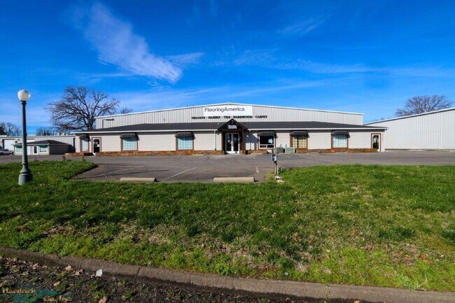
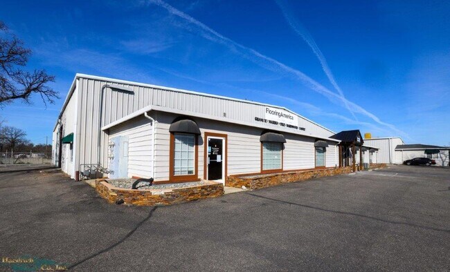
Property Record
20250 Skypark Dr, Redding, CA 96002


NEARBY LISTINGS FOR SALE OR LEASE
Property Detail
20250 Skypark Dr
Warehouse
Parcel Map 9 91
X
Shasta
06089C1570H
California
2024
0.93 AC
2025
Other Market Areas
011403
Redding, CA
15,400 SF
054-650-010-000
DEMOGRAPHICS near 20250 Skypark Dr
1 Mile
3 Mile
5 Mile
2024 Total Population
3,086
32,436
73,660
2029 Population
3,088
32,370
73,400
Pop Growth 2024-2029
+ 0.06%
(0.20%)
(0.35%)
Average Age
43
40
41
2024 Total Households
1,158
12,077
28,875
HH Growth 2024-2029
+ 0.09%
(0.19%)
(0.32%)
Median Household Inc
$91,693
$73,844
$66,506
Avg Household Size
2.60
2.60
2.50
2024 Avg HH Vehicles
2.00
2.00
2.00
Median Home Value
$491,218
$357,896
$355,548
Median Year Built
1996
1982
1981
Nearby Places
Map Layers
Map Styles
 Street
 Aerial
- Restaurants
- Banks
- Shops
- Fitness
- Groceries
PUBLIC TRANSPORTATION
COMMUTER RAIL
Redding Amtrak (Coast Starlight - Amtrak)
DRIVE
WALK
Distance
Redding Amtrak (Coast Starlight - Amtrak)
9 min
6.8 mi
AIRPORT
Redding Regional
DRIVE
WALK
Distance
Redding Regional
5 min
2.9 mi
Freight Ports
Port of Richmond
DRIVE
WALK
Distance
Port of Richmond
228 min
201.0 mi
SALE & LEASE HISTORY
LISTING DATE
SALE/LEASE

Feb 26, 2020
For Lease
Feb 26, 2020
For Sale
Feb 09, 2017
For Sale
Feb 09, 2017
For Sale
Nearby Properties
Address
Land Use
TOTAL SIZE
Lot Size
Zoning
Address
Land Use
TOTAL SIZE
Lot Size
Zoning
151,773 SF
17.64 AC
Address
Land Use
TOTAL SIZE
Lot Size
Zoning
97,213 SF
7.94 AC
Address
Land Use
TOTAL SIZE
Lot Size
Zoning
73,000 SF
4.40 AC
Address
Land Use
TOTAL SIZE
Lot Size
Zoning
143,164 SF
13.90 AC
Address
Land Use
TOTAL SIZE
Lot Size
Zoning
55,697 SF
5.08 AC
Address
Land Use
TOTAL SIZE
Lot Size
Zoning
81,800 SF
14.81 AC
Address
Land Use
TOTAL SIZE
Lot Size
Zoning
50,251 SF
4.06 AC
Address
Land Use
TOTAL SIZE
Lot Size
Zoning
11.90 AC
Address
Land Use
TOTAL SIZE
Lot Size
Zoning
11.80 AC
Address
Land Use
TOTAL SIZE
Lot Size
Zoning
4.10 AC
Address
Land Use
TOTAL SIZE
Lot Size
Zoning
10.28 AC
Address
Land Use
TOTAL SIZE
Lot Size
Zoning
90,832 SF
12.44 AC
C-2
Address
Land Use
TOTAL SIZE
Lot Size
Zoning
86,744 SF
9.25 AC
Address
Land Use
TOTAL SIZE
Lot Size
Zoning
3,178 SF
3.58 AC
Address
Land Use
TOTAL SIZE
Lot Size
Zoning
2,400 SF
13 AC
Address
Land Use
TOTAL SIZE
Lot Size
Zoning
3.43 AC
Address
Land Use
TOTAL SIZE
Lot Size
Zoning
72,000 SF
10.33 AC
Address
Land Use
TOTAL SIZE
Lot Size
Zoning
63,800 SF
3.69 AC
Address
Land Use
TOTAL SIZE
Lot Size
Zoning
3.20 AC
Address
Land Use
TOTAL SIZE
Lot Size
Zoning
3.83 AC
Address
Land Use
TOTAL SIZE
Lot Size
Zoning
22,276 SF
5.32 AC
Address
Land Use
TOTAL SIZE
Lot Size
Zoning
2,903 SF
1.54 AC
Address
Land Use
TOTAL SIZE
Lot Size
Zoning
33,929 SF
4.86 AC
Address
Land Use
TOTAL SIZE
Lot Size
Zoning
3.34 AC
Address
Land Use
TOTAL SIZE
Lot Size
Zoning
11.69 AC
Address
Land Use
TOTAL SIZE
Lot Size
Zoning
6.88 AC
Address
Land Use
TOTAL SIZE
Lot Size
Zoning
12,467 SF
2.97 AC
Address
Land Use
TOTAL SIZE
Lot Size
Zoning
59,085 SF
11.70 AC
Address
Land Use
TOTAL SIZE
Lot Size
Zoning
4.66 AC
Address
Land Use
TOTAL SIZE
Lot Size
Zoning
7.74 AC
The World's #1 Commercial Real Estate Marketplace
Connect with us
© 2025 CoStar Group
The information above has been obtained from sources believed reliable. While we do not doubt its accuracy we have not verified it and make no guarantee, warranty or representation about it. It is your responsibility to independently confirm its accuracy and completeness. Any projections, opinions, assumptions, or estimates used are for example only and do not represent the current or future performance of the property. The value of this transaction to you depends on tax and other factors which should be evaluated by your tax, financial, and legal advisors. You and your advisors should conduct a careful, independent investigation of the property to determine to your satisfaction the suitability of the property for your needs.