Property Record
2026 S Hughes Ave, Fresno, CA 93706
NEARBY LISTINGS FOR SALE OR LEASE
Property Detail
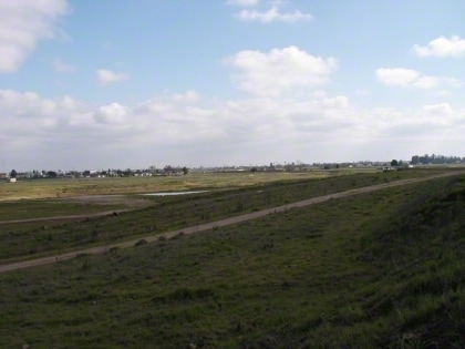
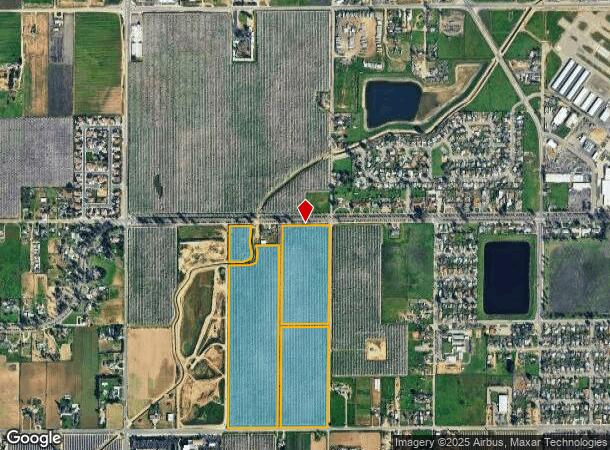
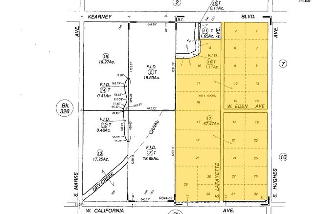
2026 S Hughes Ave
Fresno, CA
Briscoe
464-060-17
67.47 AC IN BRISCOE TRACT
Orchard
Fresno
AE
California
06019C2105H
67.47 AC
2025
West Fresno
2025
Fresno
008600
DEMOGRAPHICS near 2026 S Hughes Ave
1 Mile
3 Mile
5 Mile
2024 Total Population
3,414
55,684
196,895
2029 Population
3,455
56,589
200,249
Pop Growth 2024-2029
+ 1.20%
+ 1.63%
+ 1.70%
Average Age
37
35
34
2024 Total Households
1,109
16,589
59,267
HH Growth 2024-2029
+ 1.17%
+ 1.68%
+ 1.71%
Median Household Inc
$33,430
$32,251
$43,827
Avg Household Size
3.00
3.00
3.10
2024 Avg HH Vehicles
2.00
1.00
2.00
Median Home Value
$232,017
$219,265
$243,616
Median Year Built
1970
1965
1964
Nearby Places
Map Layers
Map Styles
 Street
 Aerial
- Restaurants
- Banks
- Shops
- Fitness
- Groceries
PUBLIC TRANSPORTATION
COMMUTER RAIL
Fresno (San Joaquins - Amtrak)
DRIVE
WALK
Distance
Fresno (San Joaquins - Amtrak)
7 min
3.4 mi
AIRPORT
Fresno Yosemite International
DRIVE
WALK
Distance
Fresno Yosemite International
15 min
9.7 mi
Freight Ports
Port of Stockton
DRIVE
WALK
Distance
Port of Stockton
153 min
127.3 mi
Nearby Properties
Address
Land Use
TOTAL SIZE
Lot Size
Zoning
Address
Land Use
TOTAL SIZE
Lot Size
Zoning
288,597 SF
1.18 AC
C4
Address
Land Use
TOTAL SIZE
Lot Size
Zoning
141,959 SF
35.39 AC
SPLIT
Address
Land Use
TOTAL SIZE
Lot Size
Zoning
101,510 SF
3.37 AC
CM
Address
Land Use
TOTAL SIZE
Lot Size
Zoning
471,760 SF
1.98 AC
CP
Address
Land Use
TOTAL SIZE
Lot Size
Zoning
213,874 SF
4.17 AC
SPLIT
Address
Land Use
TOTAL SIZE
Lot Size
Zoning
206,766 SF
17.11 AC
R2
Address
Land Use
TOTAL SIZE
Lot Size
Zoning
61,575 SF
3.50 AC
SPLIT
Address
Land Use
TOTAL SIZE
Lot Size
Zoning
96,012 SF
1.33 AC
C4
Address
Land Use
TOTAL SIZE
Lot Size
Zoning
82,096 SF
0.26 AC
C4
Address
Land Use
TOTAL SIZE
Lot Size
Zoning
96,012 SF
0.60 AC
C4
Address
Land Use
TOTAL SIZE
Lot Size
Zoning
89,097 SF
0.63 AC
CC
Address
Land Use
TOTAL SIZE
Lot Size
Zoning
37,017 SF
1.19 AC
CM
Address
Land Use
TOTAL SIZE
Lot Size
Zoning
162,050 SF
9.86 AC
R2
Address
Land Use
TOTAL SIZE
Lot Size
Zoning
71,384 SF
6.34 AC
IL
Address
Land Use
TOTAL SIZE
Lot Size
Zoning
106,740 SF
63.59 AC
AE20
Address
Land Use
TOTAL SIZE
Lot Size
Zoning
32,156 SF
2.60 AC
C6
Address
Land Use
TOTAL SIZE
Lot Size
Zoning
130,053 SF
0.69 AC
C4
Address
Land Use
TOTAL SIZE
Lot Size
Zoning
80,966 SF
8.91 AC
R2
Address
Land Use
TOTAL SIZE
Lot Size
Zoning
103,088 SF
5.41 AC
R3
Address
Land Use
TOTAL SIZE
Lot Size
Zoning
113,419 SF
1.26 AC
C4
Address
Land Use
TOTAL SIZE
Lot Size
Zoning
88,718 SF
1.64 AC
C4
Address
Land Use
TOTAL SIZE
Lot Size
Zoning
121,411 SF
0.60 AC
DTC
Address
Land Use
TOTAL SIZE
Lot Size
Zoning
43,002 SF
1.34 AC
DTN
Address
Land Use
TOTAL SIZE
Lot Size
Zoning
98,542 SF
6.94 AC
R4
Address
Land Use
TOTAL SIZE
Lot Size
Zoning
37,430 SF
0.34 AC
DTC
Address
Land Use
TOTAL SIZE
Lot Size
Zoning
130,358 SF
0.43 AC
C4
Address
Land Use
TOTAL SIZE
Lot Size
Zoning
53,928 SF
1.19 AC
C4
Address
Land Use
TOTAL SIZE
Lot Size
Zoning
171,450 SF
0.88 AC
CC
Address
Land Use
TOTAL SIZE
Lot Size
Zoning
86,559 SF
5.40 AC
R3
Address
Land Use
TOTAL SIZE
Lot Size
Zoning
57,792 SF
0.60 AC
DTN
The World's #1 Commercial Real Estate Marketplace
Connect with us
© 2026 CoStar Group
The information above has been obtained from sources believed reliable. While we do not doubt its accuracy we have not verified it and make no guarantee, warranty or representation about it. It is your responsibility to independently confirm its accuracy and completeness. Any projections, opinions, assumptions, or estimates used are for example only and do not represent the current or future performance of the property. The value of this transaction to you depends on tax and other factors which should be evaluated by your tax, financial, and legal advisors. You and your advisors should conduct a careful, independent investigation of the property to determine to your satisfaction the suitability of the property for your needs.