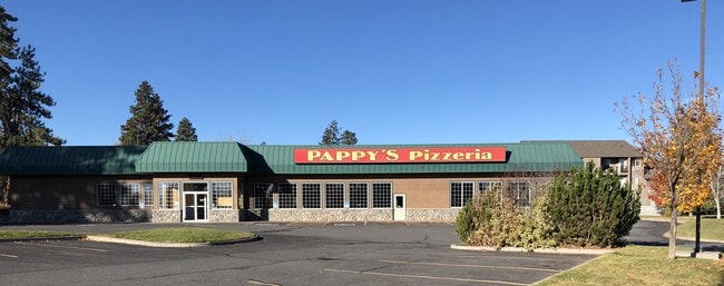
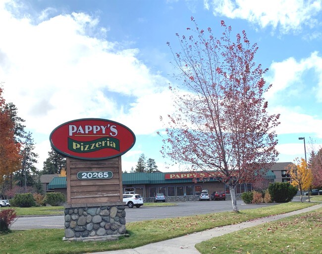
Property Record
20265 Meyer Dr, Bend, OR 97702

Property Detail
20265 Meyer Dr
177091
SEC 8 - BAAP WHICH BEARS S 50 25 48 W 2529.26 FT FRM NE COR SD SEC TH N 00 08 33 E 320.46 FT TH S 89 51 ...
Commercialnec
Deschutes
CG
Oregon
B and X Area of moderate flood hazard, usually the area between the limits of the 100-year and 500-year floods.
1.67 AC
2025
Deschutes County
2025
Portland
002101
Bend, OR
10,612 SF
NEARBY LISTINGS FOR SALE OR LEASE
DEMOGRAPHICS near 20265 Meyer Dr
1 mile
3 mile
5 mile
2024 Total Population
12,482
69,759
112,132
2029 Population
14,018
77,907
125,095
Pop Growth 2024-2029
+ 12.31%
+ 11.68%
+ 11.56%
Average Age
38
41
41
2024 Total Households
5,034
29,116
45,900
HH Growth 2024-2029
+ 12.48%
+ 11.82%
+ 11.71%
Median Household Inc
$68,560
$80,353
$84,934
Avg Household Size
2.40
2.30
2.40
2024 Avg HH Vehicles
2.00
2.00
2.00
Median Home Value
$515,977
$626,672
$633,783
Median Year Built
2004
1999
1999
Nearby Places
Map Layers
Map Styles
 Street
 Aerial
Transit
 Traffic
 Biking
Places
Listings with unknown addresses are not visible on the map
- Restaurants
- Banks
- Shops
- Fitness
- Groceries
PUBLIC TRANSPORTATION
AIRPORT
Roberts Field
Drive
Walk
Distance
Roberts Field
28 min
18.7 mi
Freight Ports
Port of Portland
Drive
Walk
Distance
Port of Portland
236 min
180.2 mi
SALE & LEASE HISTORY
LISTING DATE
SALE/LEASE

Oct 30, 2017
For Sale
Oct 26, 2017
For Sale
Feb 02, 2018
For Lease
Nearby Properties
Address
Land Use
TOTAL SIZE
Lot Size
Zoning
Address
Land Use
TOTAL SIZE
Lot Size
Zoning
3.74 AC
MR
Address
Land Use
TOTAL SIZE
Lot Size
Zoning
25,574 SF
3.74 AC
MR
Address
Land Use
TOTAL SIZE
Lot Size
Zoning
27,863 SF
4.23 AC
MU
Address
Land Use
TOTAL SIZE
Lot Size
Zoning
318,598 SF
9.77 AC
RS
Address
Land Use
TOTAL SIZE
Lot Size
Zoning
201,150 SF
3.75 AC
RH
Address
Land Use
TOTAL SIZE
Lot Size
Zoning
166,371 SF
2.52 AC
MU
Address
Land Use
TOTAL SIZE
Lot Size
Zoning
199,892 SF
19.16 AC
CG
Address
Land Use
TOTAL SIZE
Lot Size
Zoning
115,973 SF
73.55 AC
UA
Address
Land Use
TOTAL SIZE
Lot Size
Zoning
1.04 AC
CB
Address
Land Use
TOTAL SIZE
Lot Size
Zoning
201,575 SF
1.04 AC
CB
Address
Land Use
TOTAL SIZE
Lot Size
Zoning
165,048 SF
4.68 AC
RM
Address
Land Use
TOTAL SIZE
Lot Size
Zoning
1,248 SF
5.04 AC
RM
Address
Land Use
TOTAL SIZE
Lot Size
Zoning
129,449 SF
2.91 AC
MR
Address
Land Use
TOTAL SIZE
Lot Size
Zoning
46,317 SF
5.67 AC
RM
Address
Land Use
TOTAL SIZE
Lot Size
Zoning
170,218 SF
13.27 AC
RS
Address
Land Use
TOTAL SIZE
Lot Size
Zoning
49,923 SF
18.42 AC
PF
Address
Land Use
TOTAL SIZE
Lot Size
Zoning
172,121 SF
3.92 AC
RH
Address
Land Use
TOTAL SIZE
Lot Size
Zoning
132,020 SF
12.11 AC
CG
Address
Land Use
TOTAL SIZE
Lot Size
Zoning
5.73 AC
RM
Address
Land Use
TOTAL SIZE
Lot Size
Zoning
21.41 AC
MU
Address
Land Use
TOTAL SIZE
Lot Size
Zoning
2.17 AC
Address
Land Use
TOTAL SIZE
Lot Size
Zoning
88,619 SF
2.17 AC
ME
Address
Land Use
TOTAL SIZE
Lot Size
Zoning
7,920 SF
8.62 AC
RH
Address
Land Use
TOTAL SIZE
Lot Size
Zoning
164,959 SF
9.30 AC
CG
Address
Land Use
TOTAL SIZE
Lot Size
Zoning
164,959 SF
9.30 AC
CG
Address
Land Use
TOTAL SIZE
Lot Size
Zoning
3.86 AC
RM
Address
Land Use
TOTAL SIZE
Lot Size
Zoning
7.73 AC
MR
Address
Land Use
TOTAL SIZE
Lot Size
Zoning
7.73 AC
MR
Address
Land Use
TOTAL SIZE
Lot Size
Zoning
145,743 SF
9.06 AC
RM
Address
Land Use
TOTAL SIZE
Lot Size
Zoning
125,966 SF
8.19 AC
RS
The World's #1 Commercial Real Estate Marketplace
Connect with us
© 2026 CoStar Group
The information above has been obtained from sources believed reliable. While we do not doubt its accuracy we have not verified it and make no guarantee, warranty or representation about it. It is your responsibility to independently confirm its accuracy and completeness. Any projections, opinions, assumptions, or estimates used are for example only and do not represent the current or future performance of the property. The value of this transaction to you depends on tax and other factors which should be evaluated by your tax, financial, and legal advisors. You and your advisors should conduct a careful, independent investigation of the property to determine to your satisfaction the suitability of the property for your needs.