Property Record
2029 Bleecker St, Utica, NY 13501
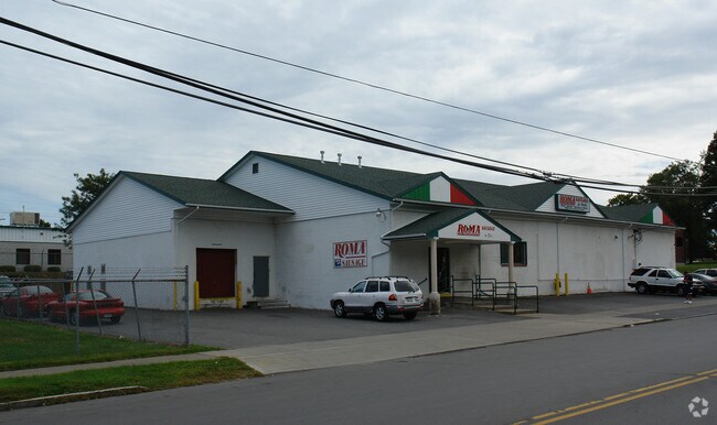

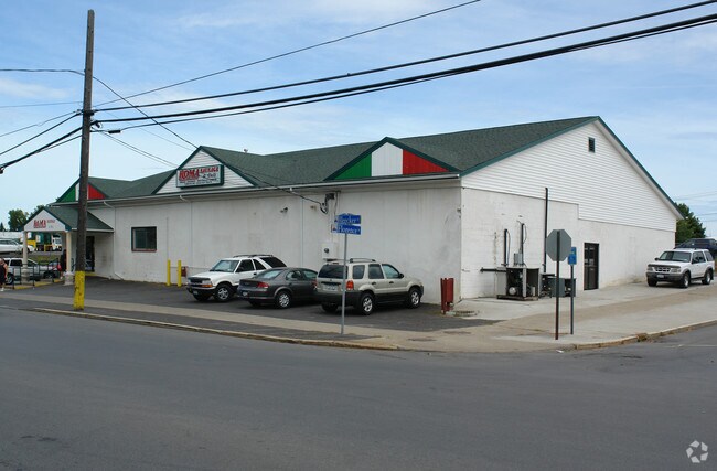
Property Detail
2029 Bleecker St
Utica-Rome, NY
1-21- -141 154X120 319.019-0001-020.000/0000
319-019-0001-020-000-0000
ONEIDA
Storesoffices
New York
B and X Area of moderate flood hazard, usually the area between the limits of the 100-year and 500-year floods.
20.000
2025
0.42 AC
2025
Utica
020802
Utica/Rome
8,400 SF
NEARBY LISTINGS FOR SALE OR LEASE
-
-
View all Utica listings for sale on LoopNet.com
DEMOGRAPHICS near 2029 Bleecker St
1 mile
3 mile
5 mile
2025 Total Population
6,535
50,328
80,837
2030 Population
6,287
49,505
79,573
Pop Growth 2025-2030
(3.79%)
(1.64%)
(1.56%)
Average Age
38
39
40
2025 Total Households
2,336
19,903
32,423
HH Growth 2025-2030
(4.20%)
(1.56%)
(1.57%)
Median Household Inc
$45,130
$44,854
$51,827
Avg Household Size
2.50
2.40
2.30
2025 Avg HH Vehicles
1.00
1.00
1.00
Median Home Value
$120,843
$154,780
$167,692
Median Year Built
1946
1949
1949
Nearby Places
Map Layers
Map Styles
 Street
 Aerial
Layers
 Traffic
 Biking
Places
Listings with unknown addresses are not visible on the map
- Restaurants
- Banks
- Shops
- Fitness
- Groceries
PUBLIC TRANSPORTATION
COMMUTER RAIL
Drive
Walk
Distance
5 min
2.2 mi
Nearby Properties
Address
Land Use
TOTAL SIZE
Lot Size
Zoning
Address
Land Use
TOTAL SIZE
Lot Size
Zoning
127,002 SF
89.68 AC
Address
Land Use
TOTAL SIZE
Lot Size
Zoning
9.79 AC
Address
Land Use
TOTAL SIZE
Lot Size
Zoning
276,146 SF
304.48 AC
Address
Land Use
TOTAL SIZE
Lot Size
Zoning
6,000 SF
1.46 AC
Address
Land Use
TOTAL SIZE
Lot Size
Zoning
12,692 SF
20.24 AC
Address
Land Use
TOTAL SIZE
Lot Size
Zoning
205,097 SF
7.90 AC
Address
Land Use
TOTAL SIZE
Lot Size
Zoning
53,777 SF
Address
Land Use
TOTAL SIZE
Lot Size
Zoning
129,948 SF
6.90 AC
Address
Land Use
TOTAL SIZE
Lot Size
Zoning
132,972 SF
30.76 AC
Address
Land Use
TOTAL SIZE
Lot Size
Zoning
87,120 SF
2.31 AC
Address
Land Use
TOTAL SIZE
Lot Size
Zoning
12,544 SF
21.80 AC
Address
Land Use
TOTAL SIZE
Lot Size
Zoning
3,472 SF
1.06 AC
Address
Land Use
TOTAL SIZE
Lot Size
Zoning
163,404 SF
2.58 AC
Address
Land Use
TOTAL SIZE
Lot Size
Zoning
209,608 SF
2.10 AC
Address
Land Use
TOTAL SIZE
Lot Size
Zoning
142,770 SF
34.25 AC
Address
Land Use
TOTAL SIZE
Lot Size
Zoning
148,962 SF
31.10 AC
Address
Land Use
TOTAL SIZE
Lot Size
Zoning
83,783 SF
0.53 AC
Address
Land Use
TOTAL SIZE
Lot Size
Zoning
115,704 SF
1.78 AC
Address
Land Use
TOTAL SIZE
Lot Size
Zoning
61,940 SF
5.31 AC
Address
Land Use
TOTAL SIZE
Lot Size
Zoning
120,484 SF
11.20 AC
Address
Land Use
TOTAL SIZE
Lot Size
Zoning
213,200 SF
2.94 AC
Address
Land Use
TOTAL SIZE
Lot Size
Zoning
109,015 SF
2.75 AC
Address
Land Use
TOTAL SIZE
Lot Size
Zoning
53,472 SF
7.60 AC
Address
Land Use
TOTAL SIZE
Lot Size
Zoning
94,550 SF
12.23 AC
Address
Land Use
TOTAL SIZE
Lot Size
Zoning
75,654 SF
11 AC
Address
Land Use
TOTAL SIZE
Lot Size
Zoning
371,680 SF
21.81 AC
Address
Land Use
TOTAL SIZE
Lot Size
Zoning
24,290 SF
7.77 AC
Address
Land Use
TOTAL SIZE
Lot Size
Zoning
219,084 SF
1.03 AC
Address
Land Use
TOTAL SIZE
Lot Size
Zoning
16,206 SF
3.14 AC
Address
Land Use
TOTAL SIZE
Lot Size
Zoning
106,875 SF
17.80 AC
The World's #1 Commercial Real Estate Marketplace
Connect with us
© 2026 CoStar Group
The information above has been obtained from sources believed reliable. While we do not doubt its accuracy we have not verified it and make no guarantee, warranty or representation about it. It is your responsibility to independently confirm its accuracy and completeness. Any projections, opinions, assumptions, or estimates used are for example only and do not represent the current or future performance of the property. The value of this transaction to you depends on tax and other factors which should be evaluated by your tax, financial, and legal advisors. You and your advisors should conduct a careful, independent investigation of the property to determine to your satisfaction the suitability of the property for your needs.