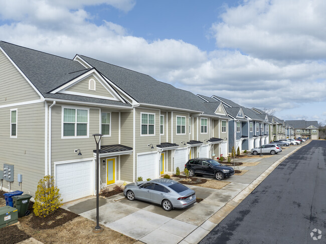
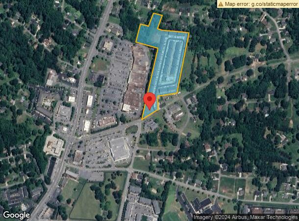
Property Record
203 29Th Ave Ne, Hickory, NC 28601

NEARBY LISTINGS FOR SALE OR LEASE
-
-
View all Hickory listings for sale on LoopNet.com
Property Detail
203 29Th Ave Ne
Hickory-Lenoir-Morganton, NC
Hazel Seabock Loveland Heirs
3714130401830000
LOTS 1- 2 & ADJ PLAT 71-12
Gardenaptcourtapt5plusunits
Catawba
X
North Carolina
3710370400K
1
2024
10.01 AC
2025
Outer City Of Hickory
010302
Charlotte
7,722 SF
DEMOGRAPHICS near 203 29Th Ave Ne
1 Mile
3 Mile
5 Mile
2024 Total Population
5,673
40,436
70,104
2029 Population
5,935
42,086
72,806
Pop Growth 2024-2029
+ 4.62%
+ 4.08%
+ 3.85%
Average Age
45
42
41
2024 Total Households
2,671
17,079
28,881
HH Growth 2024-2029
+ 4.61%
+ 4.13%
+ 3.86%
Median Household Inc
$68,777
$63,847
$57,698
Avg Household Size
2.10
2.20
2.30
2024 Avg HH Vehicles
2.00
2.00
2.00
Median Home Value
$256,814
$239,567
$202,353
Median Year Built
1986
1981
1979
Nearby Places
Map Layers
Map Styles
 Street
 Aerial
- Restaurants
- Banks
- Shops
- Fitness
- Groceries
Nearby Properties
Address
Land Use
TOTAL SIZE
Lot Size
Zoning
Address
Land Use
TOTAL SIZE
Lot Size
Zoning
10,422 SF
4.23 AC
OI
Address
Land Use
TOTAL SIZE
Lot Size
Zoning
8,492 SF
15.83 AC
R-4
Address
Land Use
TOTAL SIZE
Lot Size
Zoning
16,594 SF
7.22 AC
PD
Address
Land Use
TOTAL SIZE
Lot Size
Zoning
19.87 AC
OI
Address
Land Use
TOTAL SIZE
Lot Size
Zoning
27,008 SF
12.02 AC
R-3
Address
Land Use
TOTAL SIZE
Lot Size
Zoning
27.56 AC
OI
Address
Land Use
TOTAL SIZE
Lot Size
Zoning
17,175 SF
12.17 AC
PD
Address
Land Use
TOTAL SIZE
Lot Size
Zoning
57,658 SF
10.64 AC
OI
Address
Land Use
TOTAL SIZE
Lot Size
Zoning
8,436 SF
13.28 AC
R-4
Address
Land Use
TOTAL SIZE
Lot Size
Zoning
9,376 SF
0.75 AC
C-1
Address
Land Use
TOTAL SIZE
Lot Size
Zoning
30,415 SF
1.59 AC
C-1
Address
Land Use
TOTAL SIZE
Lot Size
Zoning
1,726 SF
15.93 AC
PD
Address
Land Use
TOTAL SIZE
Lot Size
Zoning
8,992 SF
11.66 AC
R-4
Address
Land Use
TOTAL SIZE
Lot Size
Zoning
90,440 SF
5.17 AC
OI
Address
Land Use
TOTAL SIZE
Lot Size
Zoning
9,950 SF
9.42 AC
R-3
Address
Land Use
TOTAL SIZE
Lot Size
Zoning
8,960 SF
14.07 AC
R-4
Address
Land Use
TOTAL SIZE
Lot Size
Zoning
8,637 SF
5 AC
CC-1
Address
Land Use
TOTAL SIZE
Lot Size
Zoning
14.15 AC
OI
Address
Land Use
TOTAL SIZE
Lot Size
Zoning
22,319 SF
15.57 AC
CC-1
Address
Land Use
TOTAL SIZE
Lot Size
Zoning
60,130 SF
4.02 AC
IND
Address
Land Use
TOTAL SIZE
Lot Size
Zoning
8.36 AC
OI
Address
Land Use
TOTAL SIZE
Lot Size
Zoning
6,144 SF
11.37 AC
R-4
Address
Land Use
TOTAL SIZE
Lot Size
Zoning
15,164 SF
8.29 AC
PD
Address
Land Use
TOTAL SIZE
Lot Size
Zoning
27,426 SF
7.99 AC
PD
Address
Land Use
TOTAL SIZE
Lot Size
Zoning
7,742 SF
10.93 AC
PD
Address
Land Use
TOTAL SIZE
Lot Size
Zoning
137,227 SF
12.03 AC
NC
Address
Land Use
TOTAL SIZE
Lot Size
Zoning
22.99 AC
PD
Address
Land Use
TOTAL SIZE
Lot Size
Zoning
44,116 SF
6.33 AC
OI
Address
Land Use
TOTAL SIZE
Lot Size
Zoning
24,576 SF
9.15 AC
HC
The World's #1 Commercial Real Estate Marketplace
Connect with us
© 2025 CoStar Group
The information above has been obtained from sources believed reliable. While we do not doubt its accuracy we have not verified it and make no guarantee, warranty or representation about it. It is your responsibility to independently confirm its accuracy and completeness. Any projections, opinions, assumptions, or estimates used are for example only and do not represent the current or future performance of the property. The value of this transaction to you depends on tax and other factors which should be evaluated by your tax, financial, and legal advisors. You and your advisors should conduct a careful, independent investigation of the property to determine to your satisfaction the suitability of the property for your needs.