Property Record
203 Bridgehampton Sag Hbr, Bridgehampton, NY 11932
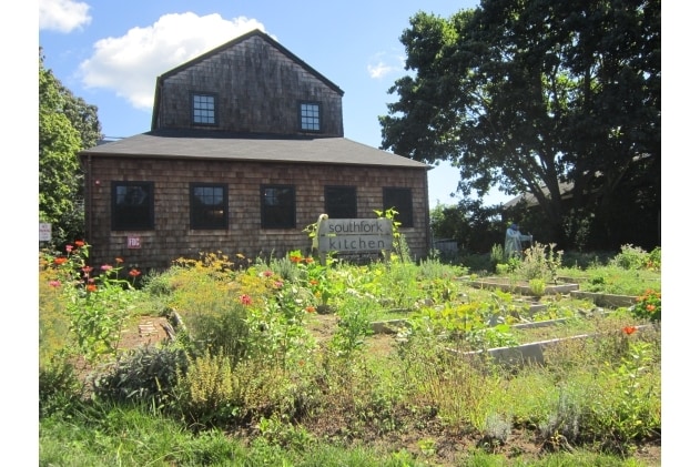


This Property Is For Sale
Property Detail
203 Bridgehampton Sag Hbr
0900-070-00-02-00-035-000
1988 LD EQ +600/IMP-200
Restaurantbuilding
SUFFOLK
R20
New York
B and X Area of moderate flood hazard, usually the area between the limits of the 100-year and 500-year floods.
35
0
0.53 AC
2025
Eastern Suffolk
190714
Long Island (New York)
3,055 SF
Nassau County-Suffolk County, NY
NEARBY LISTINGS FOR SALE OR LEASE
DEMOGRAPHICS near 203 Bridgehampton Sag Hbr
1 mile
3 mile
5 mile
2025 Total Population
786
6,122
25,881
2030 Population
735
6,198
27,649
Pop Growth 2025-2030
(6.49%)
+ 1.24%
+ 6.83%
Average Age
44
45
46
2025 Total Households
296
2,333
10,449
HH Growth 2025-2030
(7.09%)
+ 0.86%
+ 6.76%
Median Household Inc
$178,409
$146,337
$140,226
Avg Household Size
2.50
2.50
2.40
2025 Avg HH Vehicles
2.00
2.00
2.00
Median Home Value
$1,077,219
$1,100,374
$1,065,360
Median Year Built
1980
1985
1983
Nearby Places
Map Layers
Map Styles
 Street
 Aerial
Layers
 Traffic
 Biking
Places
Listings with unknown addresses are not visible on the map
- Restaurants
- Banks
- Shops
- Fitness
- Groceries
PUBLIC TRANSPORTATION
COMMUTER RAIL
Bridgehampton Station (Montauk Branch - Long Island Rail Road)
Drive
Walk
Distance
Bridgehampton Station (Montauk Branch - Long Island Rail Road)
2 min
13 min
0.7 mi
East Hampton Station (Montauk Branch - Long Island Rail Road)
Drive
Walk
Distance
East Hampton Station (Montauk Branch - Long Island Rail Road)
15 min
6.8 mi
Freight Ports
Port of New Haven
Drive
Walk
Distance
Port of New Haven
185 min
82.8 mi
Nearby Properties
Address
Land Use
TOTAL SIZE
Lot Size
Zoning
Address
Land Use
TOTAL SIZE
Lot Size
Zoning
138,725 SF
14.70 AC
SCB
Address
Land Use
TOTAL SIZE
Lot Size
Zoning
43.51 AC
R120
Address
Land Use
TOTAL SIZE
Lot Size
Zoning
46,230 SF
16.40 AC
SCB
Address
Land Use
TOTAL SIZE
Lot Size
Zoning
13,935 SF
4.07 AC
R80
Address
Land Use
TOTAL SIZE
Lot Size
Zoning
25,819 SF
2.85 AC
R80
Address
Land Use
TOTAL SIZE
Lot Size
Zoning
16.50 AC
OSC
Address
Land Use
TOTAL SIZE
Lot Size
Zoning
6,516 SF
2.44 AC
R60
Address
Land Use
TOTAL SIZE
Lot Size
Zoning
11,084 SF
7.36 AC
R120
Address
Land Use
TOTAL SIZE
Lot Size
Zoning
27,376 SF
3.01 AC
R120
Address
Land Use
TOTAL SIZE
Lot Size
Zoning
5,358 SF
1.33 AC
R60
Address
Land Use
TOTAL SIZE
Lot Size
Zoning
14,992 SF
4.40 AC
R120
Address
Land Use
TOTAL SIZE
Lot Size
Zoning
9,372 SF
1.36 AC
R60
Address
Land Use
TOTAL SIZE
Lot Size
Zoning
29,155 SF
11.12 AC
R20
Address
Land Use
TOTAL SIZE
Lot Size
Zoning
5.65 AC
R120
Address
Land Use
TOTAL SIZE
Lot Size
Zoning
16 AC
R120
Address
Land Use
TOTAL SIZE
Lot Size
Zoning
12,376 SF
3.20 AC
R120
Address
Land Use
TOTAL SIZE
Lot Size
Zoning
11,461 SF
4.10 AC
R60
Address
Land Use
TOTAL SIZE
Lot Size
Zoning
3,397 SF
1.24 AC
R60
Address
Land Use
TOTAL SIZE
Lot Size
Zoning
17,054 SF
4.13 AC
R120
Address
Land Use
TOTAL SIZE
Lot Size
Zoning
9,153 SF
2.28 AC
R120
Address
Land Use
TOTAL SIZE
Lot Size
Zoning
14,265 SF
1.81 AC
R120
Address
Land Use
TOTAL SIZE
Lot Size
Zoning
10,426 SF
4.11 AC
R120
Address
Land Use
TOTAL SIZE
Lot Size
Zoning
4,150 SF
4 AC
R120
Address
Land Use
TOTAL SIZE
Lot Size
Zoning
11,648 SF
3.36 AC
R60
Address
Land Use
TOTAL SIZE
Lot Size
Zoning
9,120 SF
2.32 AC
R120
Address
Land Use
TOTAL SIZE
Lot Size
Zoning
18.87 AC
R80
Address
Land Use
TOTAL SIZE
Lot Size
Zoning
11,650 SF
3.10 AC
R80
Address
Land Use
TOTAL SIZE
Lot Size
Zoning
26.05 AC
OSC
Address
Land Use
TOTAL SIZE
Lot Size
Zoning
16,980 SF
1.67 AC
R120
Address
Land Use
TOTAL SIZE
Lot Size
Zoning
4 AC
R120
The World's #1 Commercial Real Estate Marketplace
Connect with us
© 2026 CoStar Group
The information above has been obtained from sources believed reliable. While we do not doubt its accuracy we have not verified it and make no guarantee, warranty or representation about it. It is your responsibility to independently confirm its accuracy and completeness. Any projections, opinions, assumptions, or estimates used are for example only and do not represent the current or future performance of the property. The value of this transaction to you depends on tax and other factors which should be evaluated by your tax, financial, and legal advisors. You and your advisors should conduct a careful, independent investigation of the property to determine to your satisfaction the suitability of the property for your needs.