Property Record
203 County Route 41A, Pulaski, NY 13142

NEARBY LISTINGS FOR SALE OR LEASE
-
-
View all Pulaski listings for sale on LoopNet.com
Property Detail
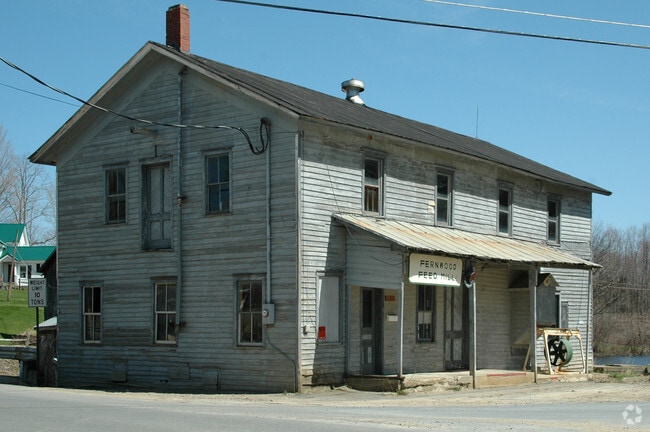
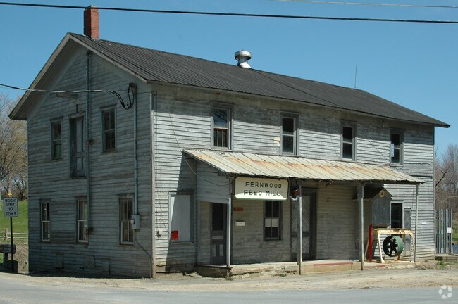
203 County Route 41A
355089-101-000-0003-027-002-0000
LOT 116 072-002-000
Grainelevator
Oswego
A
New York
36075C0335G
27.200
2025
0.11 AC
2024
Oswego County
020301
Syracuse
2,800 SF
Syracuse, NY
DEMOGRAPHICS near 203 County Route 41A
1 mile
3 mile
5 mile
2024 Total Population
271
1,764
6,365
2029 Population
280
1,793
6,385
Pop Growth 2024-2029
+ 3.32%
+ 1.64%
+ 0.31%
Average Age
42
42
42
2024 Total Households
104
678
2,490
HH Growth 2024-2029
+ 3.85%
+ 1.62%
+ 0.28%
Median Household Inc
$78,125
$72,499
$60,180
Avg Household Size
2.60
2.60
2.50
2024 Avg HH Vehicles
2.00
2.00
2.00
Median Home Value
$168,084
$146,886
$140,845
Median Year Built
1975
1973
1975
Nearby Places
Map Layers
Map Styles
 Street
 Aerial
Transit
 Traffic
 Biking
Places
Listings with unknown addresses are not visible on the map
- Restaurants
- Banks
- Shops
- Fitness
- Groceries
PUBLIC TRANSPORTATION
AIRPORT
Syracuse Hancock International
Drive
Walk
Distance
Syracuse Hancock International
41 min
30.9 mi
Nearby Properties
Address
Land Use
TOTAL SIZE
Lot Size
Zoning
Address
Land Use
TOTAL SIZE
Lot Size
Zoning
49.53 AC
02 - SINGL
Address
Land Use
TOTAL SIZE
Lot Size
Zoning
2,228 SF
61.48 AC
04 - FARM
Address
Land Use
TOTAL SIZE
Lot Size
Zoning
6.50 AC
Address
Land Use
TOTAL SIZE
Lot Size
Zoning
660 SF
19.68 AC
02 - SINGL
Address
Land Use
TOTAL SIZE
Lot Size
Zoning
3,008 SF
155 AC
02 - SINGL
Address
Land Use
TOTAL SIZE
Lot Size
Zoning
2,012 SF
33.94 AC
04 - FARM
Address
Land Use
TOTAL SIZE
Lot Size
Zoning
1,500 SF
0.93 AC
04 - FARM
Address
Land Use
TOTAL SIZE
Lot Size
Zoning
4,892 SF
1.38 AC
02 - SINGL
Address
Land Use
TOTAL SIZE
Lot Size
Zoning
2,299 SF
69.34 AC
Address
Land Use
TOTAL SIZE
Lot Size
Zoning
3,136 SF
160.42 AC
02 - SINGL
Address
Land Use
TOTAL SIZE
Lot Size
Zoning
640 SF
5.43 AC
04 - FARM
Address
Land Use
TOTAL SIZE
Lot Size
Zoning
2,312 SF
55 AC
Address
Land Use
TOTAL SIZE
Lot Size
Zoning
5,108 SF
78.23 AC
02 - SINGL
Address
Land Use
TOTAL SIZE
Lot Size
Zoning
2,300 SF
128 AC
04 - FARM
Address
Land Use
TOTAL SIZE
Lot Size
Zoning
1,920 SF
258.80 AC
02 - SINGL
Address
Land Use
TOTAL SIZE
Lot Size
Zoning
6,750 SF
3.73 AC
04 - FARM
Address
Land Use
TOTAL SIZE
Lot Size
Zoning
3,476 SF
95.03 AC
04 - FARM
Address
Land Use
TOTAL SIZE
Lot Size
Zoning
7,076 SF
1.28 AC
05 - COMME
Address
Land Use
TOTAL SIZE
Lot Size
Zoning
3,036 SF
41.63 AC
05 - COMME
Address
Land Use
TOTAL SIZE
Lot Size
Zoning
2,607 SF
77.89 AC
04 - FARM
Address
Land Use
TOTAL SIZE
Lot Size
Zoning
1,712 SF
125.52 AC
02 - SINGL
Address
Land Use
TOTAL SIZE
Lot Size
Zoning
1,723 SF
16.83 AC
04 - FARM
Address
Land Use
TOTAL SIZE
Lot Size
Zoning
1,834 SF
119.11 AC
04 - FARM
Address
Land Use
TOTAL SIZE
Lot Size
Zoning
2,693 SF
3.03 AC
04 - FARM
Address
Land Use
TOTAL SIZE
Lot Size
Zoning
1,636 SF
17.46 AC
04 - FARM
Address
Land Use
TOTAL SIZE
Lot Size
Zoning
2,041 SF
46.53 AC
04 - FARM
Address
Land Use
TOTAL SIZE
Lot Size
Zoning
1,344 SF
44.28 AC
02 - SINGL
Address
Land Use
TOTAL SIZE
Lot Size
Zoning
1,592 SF
226.34 AC
04 - FARM
Address
Land Use
TOTAL SIZE
Lot Size
Zoning
1,140 SF
53.36 AC
04 - FARM
Address
Land Use
TOTAL SIZE
Lot Size
Zoning
1,862 SF
0.92 AC
The World's #1 Commercial Real Estate Marketplace
Connect with us
© 2026 CoStar Group
The information above has been obtained from sources believed reliable. While we do not doubt its accuracy we have not verified it and make no guarantee, warranty or representation about it. It is your responsibility to independently confirm its accuracy and completeness. Any projections, opinions, assumptions, or estimates used are for example only and do not represent the current or future performance of the property. The value of this transaction to you depends on tax and other factors which should be evaluated by your tax, financial, and legal advisors. You and your advisors should conduct a careful, independent investigation of the property to determine to your satisfaction the suitability of the property for your needs.