Property Record
203 E 5Th St, Hartford, SD 57033
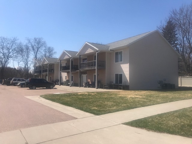

Property Detail
203 E 5Th St
Sioux Falls, SD-MN
LOT 12A HARTFORD CITY NORTH LAWN ADDITION
23594
Minnehaha
Apartment
South Dakota
B and X Area of moderate flood hazard, usually the area between the limits of the 100-year and 500-year floods.
12a
2025
0.42 AC
2025
Sioux Falls
010300
Other Market Areas
10,252 SF
NEARBY LISTINGS FOR SALE OR LEASE
-
-
View all Hartford listings for sale on LoopNet.com
DEMOGRAPHICS near 203 E 5Th St
1 mile
3 mile
5 mile
2025 Total Population
3,501
4,647
5,480
2030 Population
3,737
4,965
5,843
Pop Growth 2025-2030
+ 6.74%
+ 6.84%
+ 6.62%
Average Age
36
36
37
2025 Total Households
1,282
1,681
1,971
HH Growth 2025-2030
+ 7.10%
+ 7.14%
+ 6.95%
Median Household Inc
$85,452
$92,171
$96,401
Avg Household Size
2.70
2.80
2.80
2025 Avg HH Vehicles
2.00
2.00
2.00
Median Home Value
$278,828
$304,529
$326,635
Median Year Built
1999
2000
1998
Nearby Places
Map Layers
Map Styles
 Street
 Aerial
Layers
 Traffic
 Biking
Places
Listings with unknown addresses are not visible on the map
- Restaurants
- Banks
- Shops
- Fitness
- Groceries
PUBLIC TRANSPORTATION
AIRPORT
Joe Foss Field
Drive
Walk
Distance
Joe Foss Field
36 min
16.4 mi
Freight Ports
Port Milwaukee
Drive
Walk
Distance
Port Milwaukee
556 min
511.9 mi
SALE & LEASE HISTORY
LISTING DATE
SALE/LEASE

Apr 30, 2020
For Sale
Nearby Properties
Address
Land Use
TOTAL SIZE
Lot Size
Zoning
Address
Land Use
TOTAL SIZE
Lot Size
Zoning
67,821 SF
9.81 AC
Address
Land Use
TOTAL SIZE
Lot Size
Zoning
46,948 SF
2.21 AC
Address
Land Use
TOTAL SIZE
Lot Size
Zoning
4,040 SF
11.70 AC
A1
Address
Land Use
TOTAL SIZE
Lot Size
Zoning
28,376 SF
2 AC
Address
Land Use
TOTAL SIZE
Lot Size
Zoning
60,660 SF
18.50 AC
Address
Land Use
TOTAL SIZE
Lot Size
Zoning
11,620 SF
74.04 AC
Address
Land Use
TOTAL SIZE
Lot Size
Zoning
19,088 SF
2.39 AC
Address
Land Use
TOTAL SIZE
Lot Size
Zoning
16,992 SF
1.76 AC
Address
Land Use
TOTAL SIZE
Lot Size
Zoning
19,552 SF
1.13 AC
Address
Land Use
TOTAL SIZE
Lot Size
Zoning
1,056 SF
3.90 AC
NO;SPECIAL
Address
Land Use
TOTAL SIZE
Lot Size
Zoning
36,622 SF
2.08 AC
Address
Land Use
TOTAL SIZE
Lot Size
Zoning
15,080 SF
1.80 AC
Address
Land Use
TOTAL SIZE
Lot Size
Zoning
14,820 SF
1.87 AC
Address
Land Use
TOTAL SIZE
Lot Size
Zoning
8,961 SF
6.56 AC
Address
Land Use
TOTAL SIZE
Lot Size
Zoning
17,048 SF
1.84 AC
Address
Land Use
TOTAL SIZE
Lot Size
Zoning
56.06 AC
Address
Land Use
TOTAL SIZE
Lot Size
Zoning
16,470 SF
1.33 AC
Address
Land Use
TOTAL SIZE
Lot Size
Zoning
15,400 SF
2.14 AC
Address
Land Use
TOTAL SIZE
Lot Size
Zoning
14,256 SF
0.81 AC
Address
Land Use
TOTAL SIZE
Lot Size
Zoning
14,244 SF
0.70 AC
Address
Land Use
TOTAL SIZE
Lot Size
Zoning
13,408 SF
4.98 AC
C;COMMERCI
Address
Land Use
TOTAL SIZE
Lot Size
Zoning
11,226 SF
0.87 AC
Address
Land Use
TOTAL SIZE
Lot Size
Zoning
10,800 SF
0.84 AC
Address
Land Use
TOTAL SIZE
Lot Size
Zoning
18,320 SF
1.25 AC
Address
Land Use
TOTAL SIZE
Lot Size
Zoning
7,600 SF
1.84 AC
Address
Land Use
TOTAL SIZE
Lot Size
Zoning
12,048 SF
1.36 AC
Address
Land Use
TOTAL SIZE
Lot Size
Zoning
7.17 AC
Address
Land Use
TOTAL SIZE
Lot Size
Zoning
7,876 SF
0.94 AC
Address
Land Use
TOTAL SIZE
Lot Size
Zoning
10,080 SF
1.18 AC
The World's #1 Commercial Real Estate Marketplace
Connect with us
© 2026 CoStar Group
The information above has been obtained from sources believed reliable. While we do not doubt its accuracy we have not verified it and make no guarantee, warranty or representation about it. It is your responsibility to independently confirm its accuracy and completeness. Any projections, opinions, assumptions, or estimates used are for example only and do not represent the current or future performance of the property. The value of this transaction to you depends on tax and other factors which should be evaluated by your tax, financial, and legal advisors. You and your advisors should conduct a careful, independent investigation of the property to determine to your satisfaction the suitability of the property for your needs.