Property Record
203 N Fruitland Blvd, Fruitland, MD 21826

NEARBY LISTINGS FOR SALE OR LEASE
Property Detail
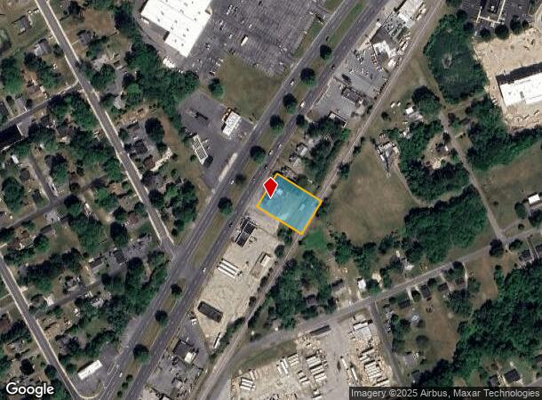
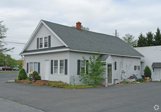
203 N Fruitland Blvd
16-007099
L-21,608 SQ FT 203 N FRUITLAND BLVD CITY OF FRUITLAND
Warehouse
Wicomico
X
Maryland
24045C0253E
0.50 AC
2024
Chesapeake Bay/Salisbury
2025
Other Market Areas
010400
Salisbury, MD-DE
496 SF
DEMOGRAPHICS near 203 N Fruitland Blvd
1 Mile
3 Mile
5 Mile
2024 Total Population
5,744
34,762
67,489
2029 Population
5,902
35,568
68,751
Pop Growth 2024-2029
+ 2.75%
+ 2.32%
+ 1.87%
Average Age
38
36
38
2024 Total Households
2,272
12,822
25,564
HH Growth 2024-2029
+ 2.86%
+ 2.39%
+ 1.93%
Median Household Inc
$61,956
$58,184
$59,196
Avg Household Size
2.50
2.50
2.50
2024 Avg HH Vehicles
2.00
2.00
2.00
Median Home Value
$219,309
$232,674
$231,335
Median Year Built
1984
1981
1980
Nearby Places
Map Layers
Map Styles
 Street
 Aerial
- Restaurants
- Banks
- Shops
- Fitness
- Groceries
PUBLIC TRANSPORTATION
AIRPORT
Salisbury-Ocean City Wicomico Regional
DRIVE
WALK
Distance
Salisbury-Ocean City Wicomico Regional
17 min
9.4 mi
Freight Ports
Port of Baltimore
DRIVE
WALK
Distance
Port of Baltimore
163 min
109.6 mi
Nearby Properties
Address
Land Use
TOTAL SIZE
Lot Size
Zoning
Address
Land Use
TOTAL SIZE
Lot Size
Zoning
1,792 SF
76.32 AC
R20
Address
Land Use
TOTAL SIZE
Lot Size
Zoning
602,336 SF
22.69 AC
H
Address
Land Use
TOTAL SIZE
Lot Size
Zoning
18,951 SF
35.15 AC
R8
Address
Land Use
TOTAL SIZE
Lot Size
Zoning
151,984 SF
35.30 AC
R4
Address
Land Use
TOTAL SIZE
Lot Size
Zoning
208,457 SF
3.05 AC
C
Address
Land Use
TOTAL SIZE
Lot Size
Zoning
32,100 SF
22.32 AC
LI
Address
Land Use
TOTAL SIZE
Lot Size
Zoning
103,992 SF
0.59 AC
CBD
Address
Land Use
TOTAL SIZE
Lot Size
Zoning
20,850 SF
12.08 AC
CU
Address
Land Use
TOTAL SIZE
Lot Size
Zoning
164,178 SF
55.53 AC
R5A
Address
Land Use
TOTAL SIZE
Lot Size
Zoning
4,093 SF
75.38 AC
R8
Address
Land Use
TOTAL SIZE
Lot Size
Zoning
14,988 SF
7.51 AC
R8A
Address
Land Use
TOTAL SIZE
Lot Size
Zoning
14,614 SF
17.23 AC
R8A
Address
Land Use
TOTAL SIZE
Lot Size
Zoning
12,024 SF
12.98 AC
R5A
Address
Land Use
TOTAL SIZE
Lot Size
Zoning
3,408 SF
69.67 AC
I
Address
Land Use
TOTAL SIZE
Lot Size
Zoning
19,608 SF
4.99 AC
CU
Address
Land Use
TOTAL SIZE
Lot Size
Zoning
58,528 SF
15.05 AC
R8
Address
Land Use
TOTAL SIZE
Lot Size
Zoning
1,034 SF
18.79 AC
R-8A
Address
Land Use
TOTAL SIZE
Lot Size
Zoning
30,000 SF
20.38 AC
CU
Address
Land Use
TOTAL SIZE
Lot Size
Zoning
64,518 SF
10.20 AC
R12
Address
Land Use
TOTAL SIZE
Lot Size
Zoning
41,473 SF
1.20 AC
CBD
Address
Land Use
TOTAL SIZE
Lot Size
Zoning
38,424 SF
4.92 AC
R15
Address
Land Use
TOTAL SIZE
Lot Size
Zoning
15,260 SF
13.52 AC
R5A
Address
Land Use
TOTAL SIZE
Lot Size
Zoning
75,556 SF
8.10 AC
R12
Address
Land Use
TOTAL SIZE
Lot Size
Zoning
61,416 SF
0.88 AC
C-4
Address
Land Use
TOTAL SIZE
Lot Size
Zoning
7,227 SF
25.06 AC
I
Address
Land Use
TOTAL SIZE
Lot Size
Zoning
54,231 SF
5.59 AC
R8A
Address
Land Use
TOTAL SIZE
Lot Size
Zoning
266,900 SF
2.03 AC
GC
Address
Land Use
TOTAL SIZE
Lot Size
Zoning
53,979 SF
4.92 AC
GC
Address
Land Use
TOTAL SIZE
Lot Size
Zoning
49,068 SF
2.92 AC
PRD
Address
Land Use
TOTAL SIZE
Lot Size
Zoning
43,250 SF
39.97 AC
GC
The World's #1 Commercial Real Estate Marketplace
Connect with us
© 2025 CoStar Group
The information above has been obtained from sources believed reliable. While we do not doubt its accuracy we have not verified it and make no guarantee, warranty or representation about it. It is your responsibility to independently confirm its accuracy and completeness. Any projections, opinions, assumptions, or estimates used are for example only and do not represent the current or future performance of the property. The value of this transaction to you depends on tax and other factors which should be evaluated by your tax, financial, and legal advisors. You and your advisors should conduct a careful, independent investigation of the property to determine to your satisfaction the suitability of the property for your needs.