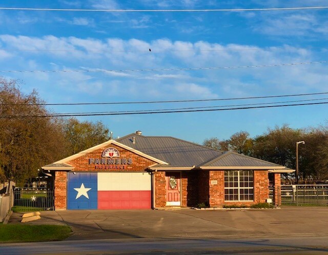
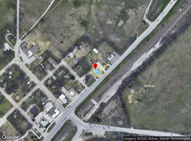
Property Record
203 N State Highway 156 N, Haslet, TX 76052

NEARBY LISTINGS FOR SALE OR LEASE
Property Detail
203 N State Highway 156 N
Dallas-Fort Worth-Arlington, TX
Haslet
01194852
HASLET, CITY OF BLOCK 21 LOT 4B & 5B
Commercialnec
Tarrant
X
Texas
48121C0630G
4b,5b
2024
0.18 AC
2025
Alliance
114111
Dallas/Ft Worth
1,349 SF
DEMOGRAPHICS near 203 N State Highway 156 N
1 Mile
3 Mile
5 Mile
2024 Total Population
174
16,851
110,872
2029 Population
191
18,572
119,949
Pop Growth 2024-2029
+ 9.77%
+ 10.21%
+ 8.19%
Average Age
33
34
34
2024 Total Households
54
5,319
35,401
HH Growth 2024-2029
+ 9.26%
+ 10.38%
+ 8.19%
Median Household Inc
$98,213
$134,996
$108,836
Avg Household Size
3.20
3.10
3.10
2024 Avg HH Vehicles
2.00
2.00
2.00
Median Home Value
$283,333
$342,278
$308,965
Median Year Built
2010
2010
2009
Nearby Places
Map Layers
Map Styles
 Street
 Aerial
- Restaurants
- Banks
- Shops
- Fitness
- Groceries
PUBLIC TRANSPORTATION
AIRPORT
Dallas-Fort Worth International
DRIVE
WALK
Distance
Dallas-Fort Worth International
33 min
24.4 mi
Freight Ports
Port of Shreveport
DRIVE
WALK
Distance
Port of Shreveport
261 min
237.9 mi
SALE & LEASE HISTORY
LISTING DATE
SALE/LEASE

Dec 01, 2023
For Sale
Aug 23, 2024
For Lease
Nearby Properties
Address
Land Use
TOTAL SIZE
Lot Size
Zoning
Address
Land Use
TOTAL SIZE
Lot Size
Zoning
348,270 SF
39.34 AC
Address
Land Use
TOTAL SIZE
Lot Size
Zoning
830,399 SF
11.02 AC
Address
Land Use
TOTAL SIZE
Lot Size
Zoning
564,806 SF
162.94 AC
Address
Land Use
TOTAL SIZE
Lot Size
Zoning
1,150,000 SF
117.10 AC
Address
Land Use
TOTAL SIZE
Lot Size
Zoning
1,141,133 SF
67.79 AC
Address
Land Use
TOTAL SIZE
Lot Size
Zoning
1,179,900 SF
73.58 AC
Address
Land Use
TOTAL SIZE
Lot Size
Zoning
882,565 SF
56.65 AC
Address
Land Use
TOTAL SIZE
Lot Size
Zoning
1,071,600 SF
74.77 AC
Address
Land Use
TOTAL SIZE
Lot Size
Zoning
1,001,600 SF
58.47 AC
Address
Land Use
TOTAL SIZE
Lot Size
Zoning
1,140,525 SF
45.79 AC
Address
Land Use
TOTAL SIZE
Lot Size
Zoning
202.10 AC
Address
Land Use
TOTAL SIZE
Lot Size
Zoning
807,229 SF
46.10 AC
Address
Land Use
TOTAL SIZE
Lot Size
Zoning
295,161 SF
257.32 AC
Address
Land Use
TOTAL SIZE
Lot Size
Zoning
279,612 SF
18.46 AC
Address
Land Use
TOTAL SIZE
Lot Size
Zoning
727,900 SF
40.15 AC
Address
Land Use
TOTAL SIZE
Lot Size
Zoning
708,400 SF
85.97 AC
Address
Land Use
TOTAL SIZE
Lot Size
Zoning
677,700 SF
42.17 AC
Address
Land Use
TOTAL SIZE
Lot Size
Zoning
634,042 SF
35.88 AC
Address
Land Use
TOTAL SIZE
Lot Size
Zoning
546,000 SF
33.60 AC
Address
Land Use
TOTAL SIZE
Lot Size
Zoning
562,500 SF
29.64 AC
Address
Land Use
TOTAL SIZE
Lot Size
Zoning
731,548 SF
56.18 AC
Address
Land Use
TOTAL SIZE
Lot Size
Zoning
184,400 SF
19.75 AC
Address
Land Use
TOTAL SIZE
Lot Size
Zoning
436,589 SF
32.43 AC
Address
Land Use
TOTAL SIZE
Lot Size
Zoning
433,500 SF
27.58 AC
Address
Land Use
TOTAL SIZE
Lot Size
Zoning
360,000 SF
28.63 AC
Address
Land Use
TOTAL SIZE
Lot Size
Zoning
218,037 SF
11.23 AC
Address
Land Use
TOTAL SIZE
Lot Size
Zoning
422,373 SF
25.13 AC
Address
Land Use
TOTAL SIZE
Lot Size
Zoning
408,000 SF
20.66 AC
Address
Land Use
TOTAL SIZE
Lot Size
Zoning
308,186 SF
44.20 AC
Address
Land Use
TOTAL SIZE
Lot Size
Zoning
436,589 SF
32.33 AC
The World's #1 Commercial Real Estate Marketplace
Connect with us
© 2026 CoStar Group
The information above has been obtained from sources believed reliable. While we do not doubt its accuracy we have not verified it and make no guarantee, warranty or representation about it. It is your responsibility to independently confirm its accuracy and completeness. Any projections, opinions, assumptions, or estimates used are for example only and do not represent the current or future performance of the property. The value of this transaction to you depends on tax and other factors which should be evaluated by your tax, financial, and legal advisors. You and your advisors should conduct a careful, independent investigation of the property to determine to your satisfaction the suitability of the property for your needs.