Property Record
203 S 4Th St, Dunlap, IL 61525
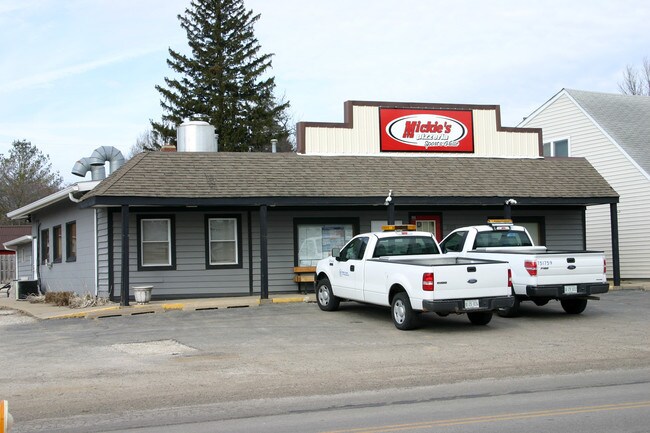

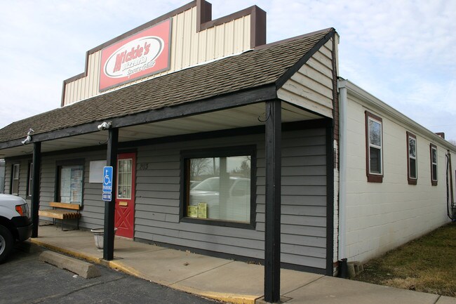
Property Detail
203 S 4Th St
Peoria
ERLE GRAZES 1ST ADD SE 1/4 SEC 10-10-7E LOTS 15-16 & N 1/2 LOT 17 (95-12625)
Peoria, IL
Peoria
08-10-477-026
Illinois
Commercialnec
15-17
2024
0.55 AC
2024
Outlying Peoria County
003900
NEARBY LISTINGS FOR SALE OR LEASE
DEMOGRAPHICS near 203 S 4Th St
1 mile
3 mile
5 mile
2025 Total Population
1,423
2,960
18,581
2030 Population
1,411
2,951
18,391
Pop Growth 2025-2030
(0.84%)
(0.30%)
(1.02%)
Average Age
38
38
37
2025 Total Households
506
1,028
6,731
HH Growth 2025-2030
(0.99%)
(0.39%)
(1.07%)
Median Household Inc
$132,353
$154,337
$136,895
Avg Household Size
2.80
2.90
2.70
2025 Avg HH Vehicles
2.00
2.00
2.00
Median Home Value
$242,207
$319,632
$326,904
Median Year Built
1975
1999
2000
Nearby Places
Map Layers
Map Styles
 Street
 Aerial
Layers
 Traffic
 Biking
Places
Listings with unknown addresses are not visible on the map
- Restaurants
- Banks
- Shops
- Fitness
- Groceries
PUBLIC TRANSPORTATION
AIRPORT
General Downing - Peoria International
Drive
Walk
Distance
General Downing - Peoria International
25 min
15.7 mi
Freight Ports
Port Milwaukee
Drive
Walk
Distance
Port Milwaukee
266 min
220.2 mi
SALE & LEASE HISTORY
LISTING DATE
SALE/LEASE

Sep 23, 2016
For Sale
Mar 29, 2017
For Sale
Nearby Properties
Address
Land Use
TOTAL SIZE
Lot Size
Zoning
Address
Land Use
TOTAL SIZE
Lot Size
Zoning
Address
Land Use
TOTAL SIZE
Lot Size
Zoning
0.77 AC
Address
Land Use
TOTAL SIZE
Lot Size
Zoning
Address
Land Use
TOTAL SIZE
Lot Size
Zoning
12,397 SF
5.23 AC
Address
Land Use
TOTAL SIZE
Lot Size
Zoning
6,534 SF
5.04 AC
Address
Land Use
TOTAL SIZE
Lot Size
Zoning
8,191 SF
25.34 AC
Address
Land Use
TOTAL SIZE
Lot Size
Zoning
3,868 SF
199.70 AC
Address
Land Use
TOTAL SIZE
Lot Size
Zoning
0.86 AC
Address
Land Use
TOTAL SIZE
Lot Size
Zoning
6,056 SF
26.47 AC
Address
Land Use
TOTAL SIZE
Lot Size
Zoning
7,416 SF
5.15 AC
Address
Land Use
TOTAL SIZE
Lot Size
Zoning
7,536 SF
30.05 AC
Address
Land Use
TOTAL SIZE
Lot Size
Zoning
5,550 SF
20 AC
Address
Land Use
TOTAL SIZE
Lot Size
Zoning
8,038 SF
4.92 AC
Address
Land Use
TOTAL SIZE
Lot Size
Zoning
1.38 AC
Address
Land Use
TOTAL SIZE
Lot Size
Zoning
6,680 SF
39.02 AC
Address
Land Use
TOTAL SIZE
Lot Size
Zoning
5,885 SF
9.41 AC
Address
Land Use
TOTAL SIZE
Lot Size
Zoning
5,070 SF
5.15 AC
Address
Land Use
TOTAL SIZE
Lot Size
Zoning
59.40 AC
Address
Land Use
TOTAL SIZE
Lot Size
Zoning
1.96 AC
Address
Land Use
TOTAL SIZE
Lot Size
Zoning
5,469 SF
12.84 AC
Address
Land Use
TOTAL SIZE
Lot Size
Zoning
2,625 SF
160 AC
Address
Land Use
TOTAL SIZE
Lot Size
Zoning
4,584 SF
118.55 AC
Address
Land Use
TOTAL SIZE
Lot Size
Zoning
4,469 SF
5.17 AC
Address
Land Use
TOTAL SIZE
Lot Size
Zoning
0.52 AC
Address
Land Use
TOTAL SIZE
Lot Size
Zoning
0.43 AC
Address
Land Use
TOTAL SIZE
Lot Size
Zoning
0.67 AC
Address
Land Use
TOTAL SIZE
Lot Size
Zoning
3,356 SF
73.76 AC
Address
Land Use
TOTAL SIZE
Lot Size
Zoning
5,514 SF
78.49 AC
Address
Land Use
TOTAL SIZE
Lot Size
Zoning
6,020 SF
5.75 AC
Address
Land Use
TOTAL SIZE
Lot Size
Zoning
4,367 SF
9.98 AC
The World's #1 Commercial Real Estate Marketplace
Connect with us
© 2026 CoStar Group
The information above has been obtained from sources believed reliable. While we do not doubt its accuracy we have not verified it and make no guarantee, warranty or representation about it. It is your responsibility to independently confirm its accuracy and completeness. Any projections, opinions, assumptions, or estimates used are for example only and do not represent the current or future performance of the property. The value of this transaction to you depends on tax and other factors which should be evaluated by your tax, financial, and legal advisors. You and your advisors should conduct a careful, independent investigation of the property to determine to your satisfaction the suitability of the property for your needs.