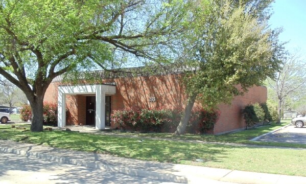
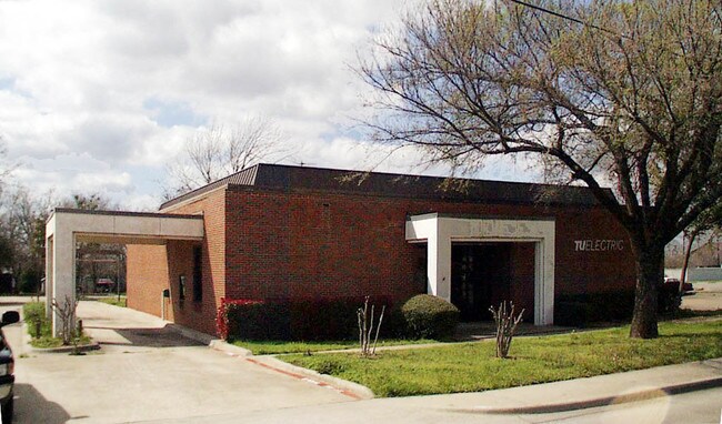
Property Record
203 S Hampton Rd, Desoto, TX 75115


NEARBY LISTINGS FOR SALE OR LEASE
Property Detail
203 S Hampton Rd
Dallas-Fort Worth-Arlington, TX
Texas Power & Light Co
20101550010010000
TEXAS POWER & LIGHT CO BLK 1 LT 1 ACS 0.868 INT202200222801 DD08152022 CO-DC 1015500100100 5CS10155001
Publicschool
Dallas
X
Texas
48139C0055G
1
2024
0.87 AC
2025
Southwest Dallas
016632
Dallas/Ft Worth
3,555 SF
DEMOGRAPHICS near 203 S Hampton Rd
1 Mile
3 Mile
5 Mile
2024 Total Population
9,484
65,399
175,969
2029 Population
9,449
64,683
179,416
Pop Growth 2024-2029
(0.37%)
(1.09%)
+ 1.96%
Average Age
39
39
37
2024 Total Households
3,231
22,645
60,691
HH Growth 2024-2029
(0.65%)
(1.36%)
+ 1.71%
Median Household Inc
$82,832
$79,675
$68,182
Avg Household Size
2.90
2.80
2.80
2024 Avg HH Vehicles
2.00
2.00
2.00
Median Home Value
$199,660
$237,422
$230,264
Median Year Built
1992
1993
1991
Nearby Places
Map Layers
Map Styles
 Street
 Aerial
- Restaurants
- Banks
- Shops
- Fitness
- Groceries
PUBLIC TRANSPORTATION
AIRPORT
Dallas Love Field
DRIVE
WALK
Distance
Dallas Love Field
33 min
21.9 mi
Dallas-Fort Worth International
DRIVE
WALK
Distance
Dallas-Fort Worth International
44 min
31.7 mi
Nearby Properties
Address
Land Use
TOTAL SIZE
Lot Size
Zoning
Address
Land Use
TOTAL SIZE
Lot Size
Zoning
123,880 SF
16.80 AC
Z236
Address
Land Use
TOTAL SIZE
Lot Size
Zoning
507,318 SF
28.40 AC
Z111
Address
Land Use
TOTAL SIZE
Lot Size
Zoning
489,310 SF
33.91 AC
Z111
Address
Land Use
TOTAL SIZE
Lot Size
Zoning
227,423 SF
13.86 AC
Z236
Address
Land Use
TOTAL SIZE
Lot Size
Zoning
281,669 SF
16.02 AC
Z312
Address
Land Use
TOTAL SIZE
Lot Size
Zoning
421,890 SF
23.95 AC
Z111
Address
Land Use
TOTAL SIZE
Lot Size
Zoning
253,794 SF
10.23 AC
Z201
Address
Land Use
TOTAL SIZE
Lot Size
Zoning
350,904 SF
18.46 AC
Z111
Address
Land Use
TOTAL SIZE
Lot Size
Zoning
140,590 SF
4.90 AC
Z236
Address
Land Use
TOTAL SIZE
Lot Size
Zoning
190,592 SF
101.54 AC
Z370
Address
Land Use
TOTAL SIZE
Lot Size
Zoning
209,742 SF
9.45 AC
Z175
Address
Land Use
TOTAL SIZE
Lot Size
Zoning
206,992 SF
14.25 AC
Z188
Address
Land Use
TOTAL SIZE
Lot Size
Zoning
210,008 SF
8.53 AC
Z175
Address
Land Use
TOTAL SIZE
Lot Size
Zoning
241,417 SF
22.80 AC
Z236
Address
Land Use
TOTAL SIZE
Lot Size
Zoning
55,213 SF
11.83 AC
Z197
Address
Land Use
TOTAL SIZE
Lot Size
Zoning
272,596 SF
56.46 AC
Z111
Address
Land Use
TOTAL SIZE
Lot Size
Zoning
161,008 SF
10.62 AC
Z188
Address
Land Use
TOTAL SIZE
Lot Size
Zoning
383 SF
56.48 AC
Z07
Address
Land Use
TOTAL SIZE
Lot Size
Zoning
169,164 SF
10.79 AC
Z187
Address
Land Use
TOTAL SIZE
Lot Size
Zoning
191,240 SF
13.73 AC
Z109
Address
Land Use
TOTAL SIZE
Lot Size
Zoning
210,202 SF
10.29 AC
Z111
Address
Land Use
TOTAL SIZE
Lot Size
Zoning
109,500 SF
12.13 AC
Z370
Address
Land Use
TOTAL SIZE
Lot Size
Zoning
207,120 SF
10 AC
Z175
Address
Land Use
TOTAL SIZE
Lot Size
Zoning
135,448 SF
9.79 AC
Z160
Address
Land Use
TOTAL SIZE
Lot Size
Zoning
382,366 SF
20.45 AC
Z111
Address
Land Use
TOTAL SIZE
Lot Size
Zoning
58,903 SF
8.25 AC
Z97
Address
Land Use
TOTAL SIZE
Lot Size
Zoning
116,640 SF
6 AC
Z175
Address
Land Use
TOTAL SIZE
Lot Size
Zoning
125,586 SF
11.71 AC
Z187
Address
Land Use
TOTAL SIZE
Lot Size
Zoning
276,880 SF
14.17 AC
Address
Land Use
TOTAL SIZE
Lot Size
Zoning
327,382 SF
15.68 AC
The World's #1 Commercial Real Estate Marketplace
Connect with us
© 2026 CoStar Group
The information above has been obtained from sources believed reliable. While we do not doubt its accuracy we have not verified it and make no guarantee, warranty or representation about it. It is your responsibility to independently confirm its accuracy and completeness. Any projections, opinions, assumptions, or estimates used are for example only and do not represent the current or future performance of the property. The value of this transaction to you depends on tax and other factors which should be evaluated by your tax, financial, and legal advisors. You and your advisors should conduct a careful, independent investigation of the property to determine to your satisfaction the suitability of the property for your needs.