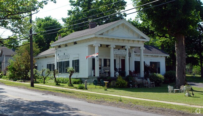
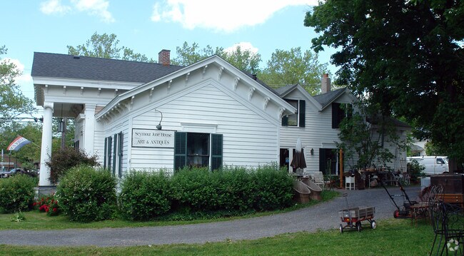
Property Record
203 S Manlius St, Fayetteville, NY 13066
NEARBY LISTINGS FOR SALE OR LEASE
Property Detail
203 S Manlius St
313801-015-000-0005-010-000-0000
FL 75 VILL BL 48
Storesoffices
Onondaga
X
New York
36067C0244F
10.000
2025
0.34 AC
2024
SE Outer Onondaga County
015100
Syracuse
2,382 SF
Syracuse, NY
DEMOGRAPHICS near 203 S Manlius St
1 Mile
3 Mile
5 Mile
2024 Total Population
5,468
26,998
58,932
2029 Population
5,325
26,347
57,480
Pop Growth 2024-2029
(2.62%)
(2.41%)
(2.46%)
Average Age
45
44
43
2024 Total Households
2,404
11,260
23,787
HH Growth 2024-2029
(2.79%)
(2.64%)
(2.60%)
Median Household Inc
$107,747
$103,851
$89,696
Avg Household Size
2.20
2.30
2.40
2024 Avg HH Vehicles
2.00
2.00
2.00
Median Home Value
$247,100
$243,516
$228,596
Median Year Built
1968
1969
1967
Nearby Places
- Restaurants
- Banks
- Shops
- Fitness
- Groceries
PUBLIC TRANSPORTATION
AIRPORT
Syracuse Hancock International
DRIVE
WALK
Distance
Syracuse Hancock International
26 min
16.3 mi
Freight Ports
Albany, NY Port
DRIVE
WALK
Distance
Albany, NY Port
170 min
137.0 mi
Nearby Properties
Address
Land Use
TOTAL SIZE
Lot Size
Zoning
Address
Land Use
TOTAL SIZE
Lot Size
Zoning
175,424 SF
7.85 AC
RA
Address
Land Use
TOTAL SIZE
Lot Size
Zoning
293,638 SF
58.90 AC
R1
Address
Land Use
TOTAL SIZE
Lot Size
Zoning
3,909 SF
24.98 AC
RA
Address
Land Use
TOTAL SIZE
Lot Size
Zoning
6.24 AC
RA
Address
Land Use
TOTAL SIZE
Lot Size
Zoning
4,722 SF
35.39 AC
R5
Address
Land Use
TOTAL SIZE
Lot Size
Zoning
163,518 SF
19.24 AC
07 - MIXED
Address
Land Use
TOTAL SIZE
Lot Size
Zoning
115,150 SF
13.32 AC
RS
Address
Land Use
TOTAL SIZE
Lot Size
Zoning
95.24 AC
05 - COMME
Address
Land Use
TOTAL SIZE
Lot Size
Zoning
15,240 SF
12.46 AC
R1
Address
Land Use
TOTAL SIZE
Lot Size
Zoning
6,936 SF
13.18 AC
R2
Address
Land Use
TOTAL SIZE
Lot Size
Zoning
78,950 SF
14.52 AC
NS
Address
Land Use
TOTAL SIZE
Lot Size
Zoning
116,748 SF
7.67 AC
R1
Address
Land Use
TOTAL SIZE
Lot Size
Zoning
24.71 AC
RA
Address
Land Use
TOTAL SIZE
Lot Size
Zoning
207,675 SF
8.23 AC
02 - SINGL
Address
Land Use
TOTAL SIZE
Lot Size
Zoning
128,733 SF
9.76 AC
RS
Address
Land Use
TOTAL SIZE
Lot Size
Zoning
165,568 SF
75.80 AC
02 - SINGL
Address
Land Use
TOTAL SIZE
Lot Size
Zoning
101,950 SF
7.32 AC
R2
Address
Land Use
TOTAL SIZE
Lot Size
Zoning
81,970 SF
29.34 AC
07 - MIXED
Address
Land Use
TOTAL SIZE
Lot Size
Zoning
32,094 SF
1.70 AC
B2
Address
Land Use
TOTAL SIZE
Lot Size
Zoning
401,546 SF
24 AC
C
Address
Land Use
TOTAL SIZE
Lot Size
Zoning
5,376 SF
8.91 AC
R2
Address
Land Use
TOTAL SIZE
Lot Size
Zoning
89,462 SF
9.22 AC
CB
Address
Land Use
TOTAL SIZE
Lot Size
Zoning
51,684 SF
17.68 AC
RA
Address
Land Use
TOTAL SIZE
Lot Size
Zoning
60,621 SF
5.63 AC
C1
Address
Land Use
TOTAL SIZE
Lot Size
Zoning
43,620 SF
33.82 AC
R1
Address
Land Use
TOTAL SIZE
Lot Size
Zoning
13,225 SF
1.48 AC
R2
Address
Land Use
TOTAL SIZE
Lot Size
Zoning
52,145 SF
4.36 AC
RS
Address
Land Use
TOTAL SIZE
Lot Size
Zoning
59,066 SF
3.46 AC
R2
Address
Land Use
TOTAL SIZE
Lot Size
Zoning
74,424 SF
35.70 AC
R1
Address
Land Use
TOTAL SIZE
Lot Size
Zoning
4,320 SF
5.67 AC
R4
The World's #1 Commercial Real Estate Marketplace
Connect with us
© 2025 CoStar Group
The information above has been obtained from sources believed reliable. While we do not doubt its accuracy we have not verified it and make no guarantee, warranty or representation about it. It is your responsibility to independently confirm its accuracy and completeness. Any projections, opinions, assumptions, or estimates used are for example only and do not represent the current or future performance of the property. The value of this transaction to you depends on tax and other factors which should be evaluated by your tax, financial, and legal advisors. You and your advisors should conduct a careful, independent investigation of the property to determine to your satisfaction the suitability of the property for your needs.