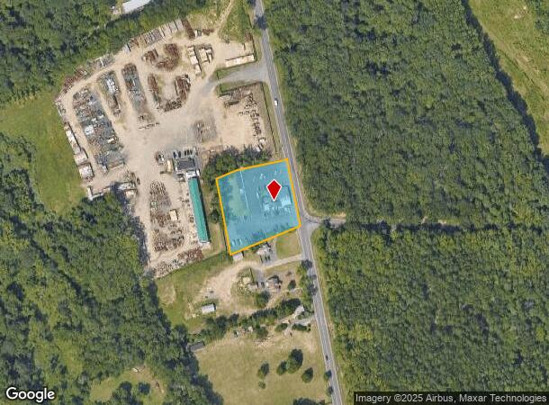
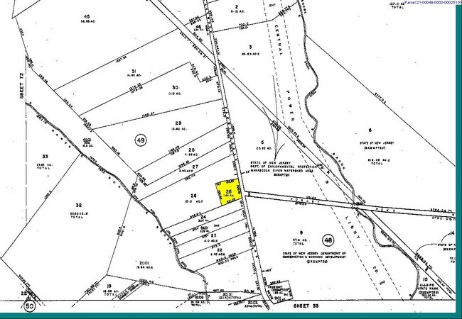
Property Record
203 Squankum Rd, Farmingdale, NJ 07727

NEARBY LISTINGS FOR SALE OR LEASE
Property Detail
203 Squankum Rd
21-00049-0000-00025
Monmouth
Bartavern
New Jersey
X
25
34025C0320F
1.44 AC
2024
Western Monmouth
2025
Northern New Jersey
811502
New York-Jersey City-White Plains, NY-NJ
4,525 SF
DEMOGRAPHICS near 203 Squankum Rd
1 Mile
3 Mile
5 Mile
2024 Total Population
812
9,708
52,321
2029 Population
838
9,645
51,901
Pop Growth 2024-2029
+ 3.20%
(0.65%)
(0.80%)
Average Age
40
41
42
2024 Total Households
302
3,441
18,195
HH Growth 2024-2029
+ 2.98%
(0.78%)
(0.99%)
Median Household Inc
$102,500
$119,025
$122,695
Avg Household Size
2.60
2.70
2.80
2024 Avg HH Vehicles
2.00
2.00
2.00
Median Home Value
$391,666
$486,313
$446,184
Median Year Built
1988
1984
1983
Nearby Places
Map Layers
Map Styles
 Street
 Aerial
- Restaurants
- Banks
- Shops
- Fitness
- Groceries
PUBLIC TRANSPORTATION
COMMUTER RAIL
Belmar (North Jersey Coast Line - NJ Transit Commuter Rail (NJ Transit))
DRIVE
WALK
Distance
Belmar (North Jersey Coast Line - NJ Transit Commuter Rail (NJ Transit))
12 min
8.9 mi
Freight Ports
New York Container Terminal
DRIVE
WALK
Distance
New York Container Terminal
57 min
42.0 mi
SALE & LEASE HISTORY
LISTING DATE
SALE/LEASE

Jul 10, 2019
For Sale
Nearby Properties
Address
Land Use
TOTAL SIZE
Lot Size
Zoning
Address
Land Use
TOTAL SIZE
Lot Size
Zoning
152,121 SF
22.16 AC
OR10
Address
Land Use
TOTAL SIZE
Lot Size
Zoning
192,708 SF
33.36 AC
OR10
Address
Land Use
TOTAL SIZE
Lot Size
Zoning
13 AC
R-40
Address
Land Use
TOTAL SIZE
Lot Size
Zoning
25,536 SF
21.95 AC
OR10
Address
Land Use
TOTAL SIZE
Lot Size
Zoning
17,586 SF
386.01 AC
POS
Address
Land Use
TOTAL SIZE
Lot Size
Zoning
912 SF
201.36 AC
RRC
Address
Land Use
TOTAL SIZE
Lot Size
Zoning
240,362 SF
61.13 AC
ARE6
Address
Land Use
TOTAL SIZE
Lot Size
Zoning
3,400 SF
262.97 AC
AI
Address
Land Use
TOTAL SIZE
Lot Size
Zoning
2,976 SF
336.41 AC
POS
Address
Land Use
TOTAL SIZE
Lot Size
Zoning
13,350 SF
71.10 AC
ARE6
Address
Land Use
TOTAL SIZE
Lot Size
Zoning
161,000 SF
21.60 AC
ARE2
Address
Land Use
TOTAL SIZE
Lot Size
Zoning
142,676 SF
10.47 AC
OR-2
Address
Land Use
TOTAL SIZE
Lot Size
Zoning
79,746 SF
9.06 AC
OR10
Address
Land Use
TOTAL SIZE
Lot Size
Zoning
4,060 SF
270.36 AC
CR40
Address
Land Use
TOTAL SIZE
Lot Size
Zoning
55,984 SF
16.11 AC
LI
Address
Land Use
TOTAL SIZE
Lot Size
Zoning
6.04 AC
OP-2
Address
Land Use
TOTAL SIZE
Lot Size
Zoning
10.11 AC
SED
Address
Land Use
TOTAL SIZE
Lot Size
Zoning
86,936 SF
3.42 AC
LI
Address
Land Use
TOTAL SIZE
Lot Size
Zoning
76,850 SF
9.90 AC
OR10
Address
Land Use
TOTAL SIZE
Lot Size
Zoning
42.76 AC
SED
Address
Land Use
TOTAL SIZE
Lot Size
Zoning
33,128 SF
12.68 AC
ARE6
Address
Land Use
TOTAL SIZE
Lot Size
Zoning
8,676 SF
8.19 AC
OP-2
Address
Land Use
TOTAL SIZE
Lot Size
Zoning
212.49 AC
ARE6
Address
Land Use
TOTAL SIZE
Lot Size
Zoning
190.72 AC
POS
Address
Land Use
TOTAL SIZE
Lot Size
Zoning
27,105 SF
9.41 AC
OP-2
Address
Land Use
TOTAL SIZE
Lot Size
Zoning
13.33 AC
SED
Address
Land Use
TOTAL SIZE
Lot Size
Zoning
7.04 AC
SED
Address
Land Use
TOTAL SIZE
Lot Size
Zoning
6.24 AC
SED
Address
Land Use
TOTAL SIZE
Lot Size
Zoning
46.34 AC
AH7
Address
Land Use
TOTAL SIZE
Lot Size
Zoning
7,764 SF
OR10
The World's #1 Commercial Real Estate Marketplace
Connect with us
© 2025 CoStar Group
The information above has been obtained from sources believed reliable. While we do not doubt its accuracy we have not verified it and make no guarantee, warranty or representation about it. It is your responsibility to independently confirm its accuracy and completeness. Any projections, opinions, assumptions, or estimates used are for example only and do not represent the current or future performance of the property. The value of this transaction to you depends on tax and other factors which should be evaluated by your tax, financial, and legal advisors. You and your advisors should conduct a careful, independent investigation of the property to determine to your satisfaction the suitability of the property for your needs.