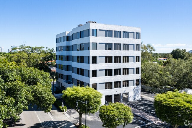
Property Record
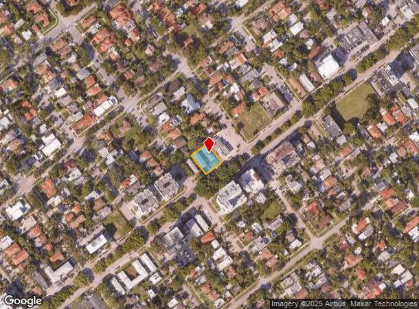
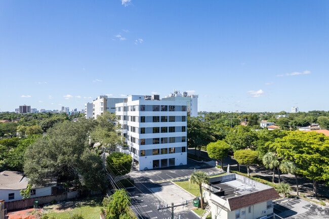
2030 Sw 3Rd Ave, Miami, FL 33129
NEARBY LISTINGS FOR SALE OR LEASE
Property Detail
2030 Sw 3Rd Ave
Miami-Miami Beach-Kendall, FL
Holleman Park
01-4138-001-1430
38-39 54 41 HOLLEMAN PARK PB 8-23 LOTS 10 & 11 BLK 10 LOT SIZE 108.000 X 130 OR 19423-1199 1200 1
Multifamilydwelling
Miami/Dade
X
Florida
12086C0314L
10,11
2024
0.32 AC
2025
Coral Way
006608
South Florida
12,362 SF
DEMOGRAPHICS near 2030 Sw 3Rd Ave
1 Mile
3 Mile
5 Mile
2024 Total Population
26,232
274,068
478,897
2029 Population
25,237
270,001
472,347
Pop Growth 2024-2029
(3.79%)
(1.48%)
(1.37%)
Average Age
44
42
41
2024 Total Households
10,245
119,423
200,809
HH Growth 2024-2029
(4.17%)
(1.59%)
(1.36%)
Median Household Inc
$65,887
$57,915
$57,844
Avg Household Size
2.40
2.20
2.30
2024 Avg HH Vehicles
2.00
1.00
1.00
Median Home Value
$569,674
$483,276
$471,889
Median Year Built
1955
1980
1978
Nearby Places
- Restaurants
- Banks
- Shops
- Fitness
- Groceries
PUBLIC TRANSPORTATION
TRANSIT/SUBWAY
Brickell (Metromover) (Metromover Brickell Loop - Miami-Dade Transit (Metrorail/Metromover))
DRIVE
WALK
Distance
Brickell (Metromover) (Metromover Brickell Loop - Miami-Dade Transit (Metrorail/Metromover))
3 min
13 min
0.7 mi
Financial District (Metromover Brickell Loop - Miami-Dade Transit (Metrorail/Metromover))
DRIVE
WALK
Distance
Financial District (Metromover Brickell Loop - Miami-Dade Transit (Metrorail/Metromover))
2 min
15 min
0.8 mi
Tenth Street/Promenade (Metromover Brickell Loop - Miami-Dade Transit (Metrorail/Metromover))
DRIVE
WALK
Distance
Tenth Street/Promenade (Metromover Brickell Loop - Miami-Dade Transit (Metrorail/Metromover))
2 min
17 min
0.9 mi
COMMUTER RAIL
Brickell (Metrorail) (Metrorail Green Line - Miami-Dade Transit (Metrorail/Metromover))
DRIVE
WALK
Distance
Brickell (Metrorail) (Metrorail Green Line - Miami-Dade Transit (Metrorail/Metromover))
3 min
14 min
0.7 mi
Vizcaya (Metrorail Green Line - Miami-Dade Transit (Metrorail/Metromover))
DRIVE
WALK
Distance
Vizcaya (Metrorail Green Line - Miami-Dade Transit (Metrorail/Metromover))
2 min
19 min
1.0 mi
AIRPORT
Miami International
DRIVE
WALK
Distance
Miami International
24 min
11.7 mi
Fort Lauderdale/Hollywood International
DRIVE
WALK
Distance
Fort Lauderdale/Hollywood International
36 min
25.2 mi
Freight Ports
Port of Miami
DRIVE
WALK
Distance
Port of Miami
11 min
4.0 mi
SALE & LEASE HISTORY
LISTING DATE
SALE/LEASE

Oct 27, 2017
For Lease
Jul 11, 2017
For Lease
Nearby Properties
Address
Land Use
TOTAL SIZE
Lot Size
Zoning
Address
Land Use
TOTAL SIZE
Lot Size
Zoning
1,050,691 SF
0.83 AC
6408
Address
Land Use
TOTAL SIZE
Lot Size
Zoning
4,758,614 SF
810.91 AC
8000
Address
Land Use
TOTAL SIZE
Lot Size
Zoning
955,966 SF
38.91 AC
9600
Address
Land Use
TOTAL SIZE
Lot Size
Zoning
2,559,318 SF
2.21 AC
6407
Address
Land Use
TOTAL SIZE
Lot Size
Zoning
2,039,308 SF
2.46 AC
6401
Address
Land Use
TOTAL SIZE
Lot Size
Zoning
928,000 SF
14.30 AC
8000
Address
Land Use
TOTAL SIZE
Lot Size
Zoning
1,110,657 SF
3.83 AC
6407
Address
Land Use
TOTAL SIZE
Lot Size
Zoning
1,346,294 SF
1.89 AC
6408
Address
Land Use
TOTAL SIZE
Lot Size
Zoning
2,403,353 SF
7.37 AC
6100
Address
Land Use
TOTAL SIZE
Lot Size
Zoning
1,162,113 SF
1.92 AC
6407
Address
Land Use
TOTAL SIZE
Lot Size
Zoning
1,544,491 SF
0.97 AC
6401
Address
Land Use
TOTAL SIZE
Lot Size
Zoning
782,686 SF
0.06 AC
6401
Address
Land Use
TOTAL SIZE
Lot Size
Zoning
1,657,362 SF
1.15 AC
6401
Address
Land Use
TOTAL SIZE
Lot Size
Zoning
1,072,012 SF
1.78 AC
6407
Address
Land Use
TOTAL SIZE
Lot Size
Zoning
244,533 SF
3.53 AC
6600
Address
Land Use
TOTAL SIZE
Lot Size
Zoning
694,863 SF
1.90 AC
6407
Address
Land Use
TOTAL SIZE
Lot Size
Zoning
656,821 SF
2.06 AC
6407
Address
Land Use
TOTAL SIZE
Lot Size
Zoning
303,989 SF
1.47 AC
6600
Address
Land Use
TOTAL SIZE
Lot Size
Zoning
416,675 SF
6.48 AC
6401
Address
Land Use
TOTAL SIZE
Lot Size
Zoning
1,004,006 SF
0.92 AC
6401
Address
Land Use
TOTAL SIZE
Lot Size
Zoning
2.50 AC
6407
Address
Land Use
TOTAL SIZE
Lot Size
Zoning
585,775 SF
1.86 AC
6101
Address
Land Use
TOTAL SIZE
Lot Size
Zoning
491,308 SF
0.14 AC
6401
Address
Land Use
TOTAL SIZE
Lot Size
Zoning
903,993 SF
0.60 AC
6412
Address
Land Use
TOTAL SIZE
Lot Size
Zoning
872,245 SF
0.56 AC
6401
Address
Land Use
TOTAL SIZE
Lot Size
Zoning
727,757 SF
0.64 AC
6408
Address
Land Use
TOTAL SIZE
Lot Size
Zoning
2 AC
8000
Address
Land Use
TOTAL SIZE
Lot Size
Zoning
1,101,032 SF
5.18 AC
8000
Address
Land Use
TOTAL SIZE
Lot Size
Zoning
1,262,330 SF
1.39 AC
6402
Address
Land Use
TOTAL SIZE
Lot Size
Zoning
616,963 SF
0.75 AC
6401
The World's #1 Commercial Real Estate Marketplace
Connect with us
© 2025 CoStar Group
The information above has been obtained from sources believed reliable. While we do not doubt its accuracy we have not verified it and make no guarantee, warranty or representation about it. It is your responsibility to independently confirm its accuracy and completeness. Any projections, opinions, assumptions, or estimates used are for example only and do not represent the current or future performance of the property. The value of this transaction to you depends on tax and other factors which should be evaluated by your tax, financial, and legal advisors. You and your advisors should conduct a careful, independent investigation of the property to determine to your satisfaction the suitability of the property for your needs.