Property Record
2030 Highway 6 S, Houston, TX 77077

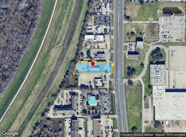

This Property Is For Sale
NEARBY LISTINGS FOR SALE OR LEASE
Property Detail
2030 Highway 6 S
1165390010016
Tim Miles Subdivision
Carwash
RES K5 BLK 1 TIM MILES SUBDIVISION
X
Harris
48157C0135L
Texas
2024
1.19 AC
2025
Southwest Beltway 8
454400
Houston
6,872 SF
Houston-The Woodlands-Sugar Land, TX
DEMOGRAPHICS near 2030 Highway 6 S
1 Mile
3 Mile
5 Mile
2024 Total Population
9,091
112,963
319,670
2029 Population
9,470
115,053
333,193
Pop Growth 2024-2029
+ 4.17%
+ 1.85%
+ 4.23%
Average Age
37
37
37
2024 Total Households
3,473
46,238
118,887
HH Growth 2024-2029
+ 3.83%
+ 1.77%
+ 3.80%
Median Household Inc
$80,409
$59,020
$62,331
Avg Household Size
2.50
2.40
2.60
2024 Avg HH Vehicles
2.00
2.00
2.00
Median Home Value
$301,527
$273,682
$256,569
Median Year Built
2003
1990
1988
Nearby Places
Map Layers
Map Styles
 Street
 Aerial
- Restaurants
- Banks
- Shops
- Fitness
- Groceries
PUBLIC TRANSPORTATION
AIRPORT
William P Hobby
DRIVE
WALK
Distance
William P Hobby
48 min
30.6 mi
George Bush Intcntl/Houston
DRIVE
WALK
Distance
George Bush Intcntl/Houston
46 min
34.5 mi
Freight Ports
Port of Houston
DRIVE
WALK
Distance
Port of Houston
45 min
30.0 mi
Nearby Properties
Address
Land Use
TOTAL SIZE
Lot Size
Zoning
Address
Land Use
TOTAL SIZE
Lot Size
Zoning
759,908 SF
4.54 AC
Address
Land Use
TOTAL SIZE
Lot Size
Zoning
953,143 SF
63.82 AC
Address
Land Use
TOTAL SIZE
Lot Size
Zoning
1,543,856 SF
10.03 AC
Address
Land Use
TOTAL SIZE
Lot Size
Zoning
1,376,776 SF
113.43 AC
Address
Land Use
TOTAL SIZE
Lot Size
Zoning
764,429 SF
6.78 AC
Address
Land Use
TOTAL SIZE
Lot Size
Zoning
1,045,896 SF
11.14 AC
Address
Land Use
TOTAL SIZE
Lot Size
Zoning
690,519 SF
26.57 AC
Address
Land Use
TOTAL SIZE
Lot Size
Zoning
617,832 SF
9.24 AC
Address
Land Use
TOTAL SIZE
Lot Size
Zoning
422,801 SF
12.71 AC
Address
Land Use
TOTAL SIZE
Lot Size
Zoning
845,902 SF
16.27 AC
Address
Land Use
TOTAL SIZE
Lot Size
Zoning
672,183 SF
8.80 AC
Address
Land Use
TOTAL SIZE
Lot Size
Zoning
803,103 SF
5.78 AC
Address
Land Use
TOTAL SIZE
Lot Size
Zoning
638,248 SF
23.38 AC
Address
Land Use
TOTAL SIZE
Lot Size
Zoning
910,592 SF
6.35 AC
Address
Land Use
TOTAL SIZE
Lot Size
Zoning
775,560 SF
7.96 AC
Address
Land Use
TOTAL SIZE
Lot Size
Zoning
487,054 SF
13.85 AC
Address
Land Use
TOTAL SIZE
Lot Size
Zoning
403,650 SF
20.19 AC
Address
Land Use
TOTAL SIZE
Lot Size
Zoning
709,724 SF
6.17 AC
Address
Land Use
TOTAL SIZE
Lot Size
Zoning
488,573 SF
20.57 AC
Address
Land Use
TOTAL SIZE
Lot Size
Zoning
499,216 SF
6.30 AC
Address
Land Use
TOTAL SIZE
Lot Size
Zoning
490,046 SF
4.59 AC
Address
Land Use
TOTAL SIZE
Lot Size
Zoning
682,312 SF
4.67 AC
Address
Land Use
TOTAL SIZE
Lot Size
Zoning
497,267 SF
24.69 AC
Address
Land Use
TOTAL SIZE
Lot Size
Zoning
511,135 SF
10.45 AC
Address
Land Use
TOTAL SIZE
Lot Size
Zoning
604,254 SF
4.38 AC
Address
Land Use
TOTAL SIZE
Lot Size
Zoning
437,786 SF
5.46 AC
Address
Land Use
TOTAL SIZE
Lot Size
Zoning
550,035 SF
5.77 AC
Address
Land Use
TOTAL SIZE
Lot Size
Zoning
489,192 SF
23.11 AC
Address
Land Use
TOTAL SIZE
Lot Size
Zoning
359,116 SF
15.35 AC
Address
Land Use
TOTAL SIZE
Lot Size
Zoning
386,068 SF
18.36 AC
The World's #1 Commercial Real Estate Marketplace
Connect with us
© 2025 CoStar Group
The information above has been obtained from sources believed reliable. While we do not doubt its accuracy we have not verified it and make no guarantee, warranty or representation about it. It is your responsibility to independently confirm its accuracy and completeness. Any projections, opinions, assumptions, or estimates used are for example only and do not represent the current or future performance of the property. The value of this transaction to you depends on tax and other factors which should be evaluated by your tax, financial, and legal advisors. You and your advisors should conduct a careful, independent investigation of the property to determine to your satisfaction the suitability of the property for your needs.