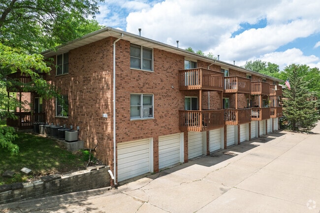
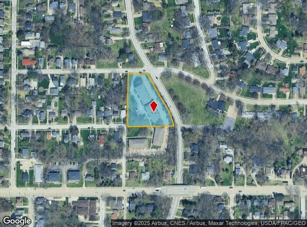
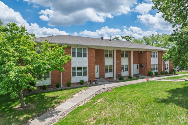
Property Record
2030 Jersey Ridge Rd, Davenport, IA 52803
NEARBY LISTINGS FOR SALE OR LEASE
Property Detail
2030 Jersey Ridge Rd
Davenport-Moline-Rock Island, IA-IL
Manor Heights Annex
D0060-17C
MANOR HEIGHTS ANNEX LOT: 003 MANOR HEIGHTS ANNEXLOT 2 &
Apartment
Scott
X
Iowa
19163C0370H
3
2025
1.08 AC
2025
East End
013000
Davenport/Moline/Rock Island
10,032 SF
DEMOGRAPHICS near 2030 Jersey Ridge Rd
1 Mile
3 Mile
5 Mile
2024 Total Population
8,748
81,240
195,626
2029 Population
8,670
80,790
193,710
Pop Growth 2024-2029
(0.89%)
(0.55%)
(0.98%)
Average Age
41
39
40
2024 Total Households
3,768
34,343
81,601
HH Growth 2024-2029
(1.04%)
(0.49%)
(1.02%)
Median Household Inc
$74,655
$55,446
$58,425
Avg Household Size
2.30
2.20
2.30
2024 Avg HH Vehicles
2.00
2.00
2.00
Median Home Value
$178,225
$162,643
$156,347
Median Year Built
1948
1960
1960
Nearby Places
Map Layers
Map Styles
 Street
 Aerial
- Restaurants
- Banks
- Shops
- Fitness
- Groceries
PUBLIC TRANSPORTATION
AIRPORT
Quad Cities International
DRIVE
WALK
Distance
Quad Cities International
24 min
12.6 mi
Freight Ports
Port Milwaukee
DRIVE
WALK
Distance
Port Milwaukee
242 min
212.8 mi
Nearby Properties
Address
Land Use
TOTAL SIZE
Lot Size
Zoning
Address
Land Use
TOTAL SIZE
Lot Size
Zoning
7,934 SF
8.41 AC
Address
Land Use
TOTAL SIZE
Lot Size
Zoning
3,516 SF
26.74 AC
Address
Land Use
TOTAL SIZE
Lot Size
Zoning
157,798 SF
25.37 AC
Address
Land Use
TOTAL SIZE
Lot Size
Zoning
157,587 SF
33.92 AC
Address
Land Use
TOTAL SIZE
Lot Size
Zoning
197,194 SF
5.14 AC
Address
Land Use
TOTAL SIZE
Lot Size
Zoning
253,608 SF
9.29 AC
Address
Land Use
TOTAL SIZE
Lot Size
Zoning
3,500 SF
1.54 AC
Address
Land Use
TOTAL SIZE
Lot Size
Zoning
27,225 SF
40.34 AC
Address
Land Use
TOTAL SIZE
Lot Size
Zoning
27,306 SF
50.57 AC
Address
Land Use
TOTAL SIZE
Lot Size
Zoning
4,518 SF
6.27 AC
Address
Land Use
TOTAL SIZE
Lot Size
Zoning
190,832 SF
3.88 AC
Address
Land Use
TOTAL SIZE
Lot Size
Zoning
63,359 SF
12.01 AC
Address
Land Use
TOTAL SIZE
Lot Size
Zoning
472,569 SF
47.24 AC
Address
Land Use
TOTAL SIZE
Lot Size
Zoning
123,823 SF
6.46 AC
Address
Land Use
TOTAL SIZE
Lot Size
Zoning
61,623 SF
2.18 AC
Address
Land Use
TOTAL SIZE
Lot Size
Zoning
1,800 SF
60.86 AC
Address
Land Use
TOTAL SIZE
Lot Size
Zoning
76,853 SF
0.56 AC
Address
Land Use
TOTAL SIZE
Lot Size
Zoning
4,944 SF
17.91 AC
Address
Land Use
TOTAL SIZE
Lot Size
Zoning
25,176 SF
13.85 AC
Address
Land Use
TOTAL SIZE
Lot Size
Zoning
26,472 SF
17.67 AC
Address
Land Use
TOTAL SIZE
Lot Size
Zoning
77,187 SF
0.88 AC
Address
Land Use
TOTAL SIZE
Lot Size
Zoning
76,808 SF
1.94 AC
Address
Land Use
TOTAL SIZE
Lot Size
Zoning
27,312 SF
15.04 AC
Address
Land Use
TOTAL SIZE
Lot Size
Zoning
70,098 SF
9.72 AC
Address
Land Use
TOTAL SIZE
Lot Size
Zoning
8,000 SF
4.59 AC
Address
Land Use
TOTAL SIZE
Lot Size
Zoning
111,979 SF
6.86 AC
Address
Land Use
TOTAL SIZE
Lot Size
Zoning
104,415 SF
5.89 AC
Address
Land Use
TOTAL SIZE
Lot Size
Zoning
156,632 SF
17.67 AC
Address
Land Use
TOTAL SIZE
Lot Size
Zoning
71,820 SF
5.71 AC
Address
Land Use
TOTAL SIZE
Lot Size
Zoning
9,658 SF
8.07 AC
The World's #1 Commercial Real Estate Marketplace
Connect with us
© 2025 CoStar Group
The information above has been obtained from sources believed reliable. While we do not doubt its accuracy we have not verified it and make no guarantee, warranty or representation about it. It is your responsibility to independently confirm its accuracy and completeness. Any projections, opinions, assumptions, or estimates used are for example only and do not represent the current or future performance of the property. The value of this transaction to you depends on tax and other factors which should be evaluated by your tax, financial, and legal advisors. You and your advisors should conduct a careful, independent investigation of the property to determine to your satisfaction the suitability of the property for your needs.