Property Record
2030 N Mall Dr, Alexandria, LA 71301
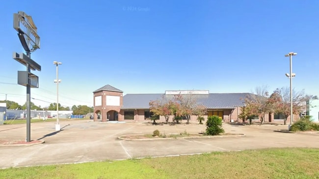

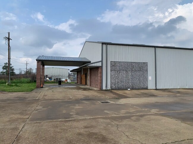
This Property Is For Sale
NEARBY LISTINGS FOR SALE OR LEASE
Property Detail
2030 N Mall Dr
Other Market Areas
Sterkx-Deming
Alexandria, LA
2.086 ACS: BEING PART BLK 7, STERKX-DEMING SUBD; NORTH OF ROAD (CB 554-117)(CB 873-645 SUCC)(CB 1068-331 SUCC)(CB 1470-463 SU
24-042-08738-0010
Rapides
Officebuilding
Louisiana
2024
2 AC
2024
Louisiana North Area
012600
DEMOGRAPHICS near 2030 N Mall Dr
1 Mile
3 Mile
5 Mile
2024 Total Population
4,103
41,676
58,760
2029 Population
4,130
41,126
58,114
Pop Growth 2024-2029
+ 0.66%
(1.32%)
(1.10%)
Average Age
42
40
39
2024 Total Households
1,639
17,028
23,794
HH Growth 2024-2029
+ 0.73%
(1.36%)
(1.19%)
Median Household Inc
$36,869
$41,669
$43,220
Avg Household Size
2.30
2.30
2.30
2024 Avg HH Vehicles
1.00
1.00
1.00
Median Home Value
$90,770
$155,720
$160,203
Median Year Built
1960
1969
1972
Nearby Places
Map Layers
Map Styles
 Street
 Aerial
- Restaurants
- Banks
- Shops
- Fitness
- Groceries
PUBLIC TRANSPORTATION
AIRPORT
Alexandria International
DRIVE
WALK
Distance
Alexandria International
25 min
10.2 mi
Nearby Properties
Address
Land Use
TOTAL SIZE
Lot Size
Zoning
Address
Land Use
TOTAL SIZE
Lot Size
Zoning
Address
Land Use
TOTAL SIZE
Lot Size
Zoning
Address
Land Use
TOTAL SIZE
Lot Size
Zoning
Address
Land Use
TOTAL SIZE
Lot Size
Zoning
Address
Land Use
TOTAL SIZE
Lot Size
Zoning
82,585 SF
9 AC
Address
Land Use
TOTAL SIZE
Lot Size
Zoning
Address
Land Use
TOTAL SIZE
Lot Size
Zoning
Address
Land Use
TOTAL SIZE
Lot Size
Zoning
Address
Land Use
TOTAL SIZE
Lot Size
Zoning
Address
Land Use
TOTAL SIZE
Lot Size
Zoning
Address
Land Use
TOTAL SIZE
Lot Size
Zoning
Address
Land Use
TOTAL SIZE
Lot Size
Zoning
33,778 SF
2.59 AC
Address
Land Use
TOTAL SIZE
Lot Size
Zoning
54,135 SF
7 AC
Address
Land Use
TOTAL SIZE
Lot Size
Zoning
Address
Land Use
TOTAL SIZE
Lot Size
Zoning
Address
Land Use
TOTAL SIZE
Lot Size
Zoning
59,500 SF
2.23 AC
Address
Land Use
TOTAL SIZE
Lot Size
Zoning
Address
Land Use
TOTAL SIZE
Lot Size
Zoning
3.07 AC
Address
Land Use
TOTAL SIZE
Lot Size
Zoning
10.27 AC
Address
Land Use
TOTAL SIZE
Lot Size
Zoning
Address
Land Use
TOTAL SIZE
Lot Size
Zoning
Address
Land Use
TOTAL SIZE
Lot Size
Zoning
57,867 SF
1.80 AC
Address
Land Use
TOTAL SIZE
Lot Size
Zoning
Address
Land Use
TOTAL SIZE
Lot Size
Zoning
Address
Land Use
TOTAL SIZE
Lot Size
Zoning
Address
Land Use
TOTAL SIZE
Lot Size
Zoning
318,655 SF
19.14 AC
Address
Land Use
TOTAL SIZE
Lot Size
Zoning
100,959 SF
9 AC
Address
Land Use
TOTAL SIZE
Lot Size
Zoning
Address
Land Use
TOTAL SIZE
Lot Size
Zoning
4.13 AC
The World's #1 Commercial Real Estate Marketplace
Connect with us
© 2026 CoStar Group
The information above has been obtained from sources believed reliable. While we do not doubt its accuracy we have not verified it and make no guarantee, warranty or representation about it. It is your responsibility to independently confirm its accuracy and completeness. Any projections, opinions, assumptions, or estimates used are for example only and do not represent the current or future performance of the property. The value of this transaction to you depends on tax and other factors which should be evaluated by your tax, financial, and legal advisors. You and your advisors should conduct a careful, independent investigation of the property to determine to your satisfaction the suitability of the property for your needs.