Property Record
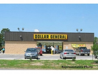
2030 N Siwell Rd, Jackson, MS 39212

Property Detail
2030 N Siwell Rd
0845-0350-003
BEG 271.06 FT S INT E/L SIWELL RD & S/L HWY 18 E 240 FT S 185 FT W 240 FT N 185 FT TO POB IN NW 1/4 SEC 21 T5N R1W
Departmentstore
Hinds
B and X Area of moderate flood hazard, usually the area between the limits of the 100-year and 500-year floods.
Mississippi
2024
43,559.92 AC
2025
South Jackson
010808
Jackson
9,146 SF
Jackson, MS
NEARBY LISTINGS FOR SALE OR LEASE
DEMOGRAPHICS near 2030 N Siwell Rd
1 mile
3 mile
5 mile
2025 Total Population
1,978
12,822
55,148
2030 Population
1,843
11,898
52,535
Pop Growth 2025-2030
(6.83%)
(7.21%)
(4.74%)
Average Age
42
40
38
2025 Total Households
805
5,128
21,397
HH Growth 2025-2030
(6.96%)
(7.43%)
(5.02%)
Median Household Inc
$61,210
$61,073
$55,636
Avg Household Size
2.40
2.50
2.50
2025 Avg HH Vehicles
2.00
2.00
2.00
Median Home Value
$145,500
$157,904
$156,612
Median Year Built
1975
1978
1976
Nearby Places
Map Layers
Map Styles
 Street
 Aerial
Layers
 Traffic
 Biking
Places
Listings with unknown addresses are not visible on the map
- Restaurants
- Banks
- Shops
- Fitness
- Groceries
PUBLIC TRANSPORTATION
COMMUTER RAIL
Drive
Walk
Distance
15 min
8.3 mi
AIRPORT
Jackson-Medgar Wiley Evers International
Drive
Walk
Distance
Jackson-Medgar Wiley Evers International
28 min
18.4 mi
Nearby Properties
Address
Land Use
TOTAL SIZE
Lot Size
Zoning
Address
Land Use
TOTAL SIZE
Lot Size
Zoning
113,434 SF
82.60 AC
Address
Land Use
TOTAL SIZE
Lot Size
Zoning
41,110 SF
4.48 AC
Address
Land Use
TOTAL SIZE
Lot Size
Zoning
199,954 SF
23 AC
Address
Land Use
TOTAL SIZE
Lot Size
Zoning
138,086 SF
14 AC
Address
Land Use
TOTAL SIZE
Lot Size
Zoning
11,950 SF
2 AC
Address
Land Use
TOTAL SIZE
Lot Size
Zoning
13,721 SF
1.80 AC
Address
Land Use
TOTAL SIZE
Lot Size
Zoning
21.12 AC
Address
Land Use
TOTAL SIZE
Lot Size
Zoning
185,868 SF
12 AC
Address
Land Use
TOTAL SIZE
Lot Size
Zoning
11,354 SF
50.54 AC
Address
Land Use
TOTAL SIZE
Lot Size
Zoning
163,800 SF
9.10 AC
Address
Land Use
TOTAL SIZE
Lot Size
Zoning
6,790 SF
0.75 AC
Address
Land Use
TOTAL SIZE
Lot Size
Zoning
36.60 AC
Address
Land Use
TOTAL SIZE
Lot Size
Zoning
8.40 AC
Address
Land Use
TOTAL SIZE
Lot Size
Zoning
15.95 AC
Address
Land Use
TOTAL SIZE
Lot Size
Zoning
5,564 SF
1.03 AC
Address
Land Use
TOTAL SIZE
Lot Size
Zoning
23,600 SF
2.09 AC
Address
Land Use
TOTAL SIZE
Lot Size
Zoning
Address
Land Use
TOTAL SIZE
Lot Size
Zoning
4,675 SF
14.50 AC
Address
Land Use
TOTAL SIZE
Lot Size
Zoning
6,801 SF
1.30 AC
Address
Land Use
TOTAL SIZE
Lot Size
Zoning
23.60 AC
Address
Land Use
TOTAL SIZE
Lot Size
Zoning
7,872 SF
0.48 AC
Address
Land Use
TOTAL SIZE
Lot Size
Zoning
4,760 SF
1 AC
Address
Land Use
TOTAL SIZE
Lot Size
Zoning
127 AC
Address
Land Use
TOTAL SIZE
Lot Size
Zoning
248,292.01 AC
Address
Land Use
TOTAL SIZE
Lot Size
Zoning
82,312 SF
5.50 AC
Address
Land Use
TOTAL SIZE
Lot Size
Zoning
5.46 AC
Address
Land Use
TOTAL SIZE
Lot Size
Zoning
Address
Land Use
TOTAL SIZE
Lot Size
Zoning
8.60 AC
Address
Land Use
TOTAL SIZE
Lot Size
Zoning
73,987 SF
16.50 AC
Address
Land Use
TOTAL SIZE
Lot Size
Zoning
42.21 AC
The World's #1 Commercial Real Estate Marketplace
Connect with us
© 2026 CoStar Group
The information above has been obtained from sources believed reliable. While we do not doubt its accuracy we have not verified it and make no guarantee, warranty or representation about it. It is your responsibility to independently confirm its accuracy and completeness. Any projections, opinions, assumptions, or estimates used are for example only and do not represent the current or future performance of the property. The value of this transaction to you depends on tax and other factors which should be evaluated by your tax, financial, and legal advisors. You and your advisors should conduct a careful, independent investigation of the property to determine to your satisfaction the suitability of the property for your needs.