Property Record
2030 Route 9W, Marlboro, NY 12542
NEARBY LISTINGS FOR SALE OR LEASE
Property Detail
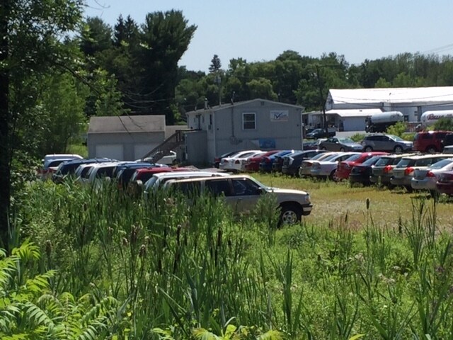
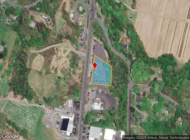
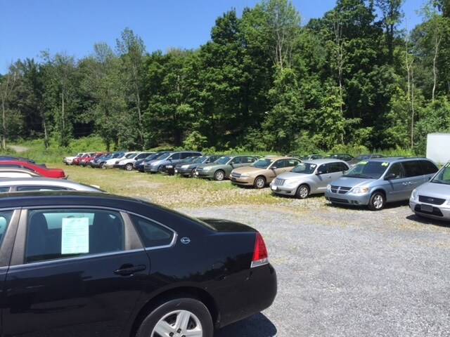
2030 Route 9W
3600-103.001-0002-081.000-0000
Ulster
Vehiclerentalsvehiclesales
New York
X
81.000
36027C0362E
1.04 AC
2025
Newburgh/Kingston
2024
Other Market Areas
953800
Kingston, NY
1,200 SF
DEMOGRAPHICS near 2030 Route 9W
1 Mile
3 Mile
5 Mile
2024 Total Population
689
36,730
90,800
2029 Population
682
36,625
90,761
Pop Growth 2024-2029
(1.02%)
(0.29%)
(0.04%)
Average Age
43
42
40
2024 Total Households
277
15,526
34,457
HH Growth 2024-2029
(1.08%)
(0.19%)
+ 0.03%
Median Household Inc
$86,184
$67,146
$72,813
Avg Household Size
2.50
2.20
2.40
2024 Avg HH Vehicles
2.00
1.00
2.00
Median Home Value
$334,523
$296,669
$291,541
Median Year Built
1976
1963
1965
Nearby Places
- Restaurants
- Banks
- Shops
- Fitness
- Groceries
PUBLIC TRANSPORTATION
COMMUTER RAIL
Poughkeepsie Station (Hudson Line - Metro-North Commuter Railroad Company (Metro-North))
DRIVE
WALK
Distance
Poughkeepsie Station (Hudson Line - Metro-North Commuter Railroad Company (Metro-North))
10 min
5.0 mi
AIRPORT
New York Stewart International
DRIVE
WALK
Distance
New York Stewart International
26 min
18.8 mi
Freight Ports
Port of New Haven
DRIVE
WALK
Distance
Port of New Haven
112 min
85.6 mi
SALE & LEASE HISTORY
LISTING DATE
SALE/LEASE

Sep 24, 2016
For Sale
Nearby Properties
Address
Land Use
TOTAL SIZE
Lot Size
Zoning
Address
Land Use
TOTAL SIZE
Lot Size
Zoning
640,854 SF
21.22 AC
H-M
Address
Land Use
TOTAL SIZE
Lot Size
Zoning
193.80 AC
IH
Address
Land Use
TOTAL SIZE
Lot Size
Zoning
488,904 SF
12.90 AC
R-3
Address
Land Use
TOTAL SIZE
Lot Size
Zoning
3 AC
R-D
Address
Land Use
TOTAL SIZE
Lot Size
Zoning
11,803 SF
99.04 AC
IH
Address
Land Use
TOTAL SIZE
Lot Size
Zoning
39.21 AC
R-1
Address
Land Use
TOTAL SIZE
Lot Size
Zoning
50,363 SF
47.88 AC
IH/R1
Address
Land Use
TOTAL SIZE
Lot Size
Zoning
16,947 SF
6.40 AC
IH
Address
Land Use
TOTAL SIZE
Lot Size
Zoning
108,096 SF
2.50 AC
C-2
Address
Land Use
TOTAL SIZE
Lot Size
Zoning
105,762 SF
2.41 AC
H-M
Address
Land Use
TOTAL SIZE
Lot Size
Zoning
5.29 AC
I-2
Address
Land Use
TOTAL SIZE
Lot Size
Zoning
4 AC
R-1
Address
Land Use
TOTAL SIZE
Lot Size
Zoning
296,400 SF
0.66 AC
C-2
Address
Land Use
TOTAL SIZE
Lot Size
Zoning
2.53 AC
R-D
Address
Land Use
TOTAL SIZE
Lot Size
Zoning
126,616 SF
25.57 AC
R20
Address
Land Use
TOTAL SIZE
Lot Size
Zoning
30,420 SF
11.30 AC
R-2
Address
Land Use
TOTAL SIZE
Lot Size
Zoning
55,299 SF
1.45 AC
C-1
Address
Land Use
TOTAL SIZE
Lot Size
Zoning
31,608 SF
57 AC
IN
Address
Land Use
TOTAL SIZE
Lot Size
Zoning
297,663 SF
4.45 AC
H-M
Address
Land Use
TOTAL SIZE
Lot Size
Zoning
Address
Land Use
TOTAL SIZE
Lot Size
Zoning
115,817 SF
5.93 AC
R5
Address
Land Use
TOTAL SIZE
Lot Size
Zoning
272,228 SF
25.20 AC
BSC
Address
Land Use
TOTAL SIZE
Lot Size
Zoning
93,216 SF
22.80 AC
PRD
Address
Land Use
TOTAL SIZE
Lot Size
Zoning
66,956 SF
9.60 AC
R4
Address
Land Use
TOTAL SIZE
Lot Size
Zoning
66,193 SF
5.57 AC
R1
Address
Land Use
TOTAL SIZE
Lot Size
Zoning
229,185 SF
4.90 AC
R-6
Address
Land Use
TOTAL SIZE
Lot Size
Zoning
73,130 SF
2.55 AC
H-M
Address
Land Use
TOTAL SIZE
Lot Size
Zoning
55,752 SF
16.14 AC
RM
Address
Land Use
TOTAL SIZE
Lot Size
Zoning
114,443 SF
43.60 AC
IN
Address
Land Use
TOTAL SIZE
Lot Size
Zoning
147,858 SF
12.45 AC
BSC
The World's #1 Commercial Real Estate Marketplace
Connect with us
© 2025 CoStar Group
The information above has been obtained from sources believed reliable. While we do not doubt its accuracy we have not verified it and make no guarantee, warranty or representation about it. It is your responsibility to independently confirm its accuracy and completeness. Any projections, opinions, assumptions, or estimates used are for example only and do not represent the current or future performance of the property. The value of this transaction to you depends on tax and other factors which should be evaluated by your tax, financial, and legal advisors. You and your advisors should conduct a careful, independent investigation of the property to determine to your satisfaction the suitability of the property for your needs.