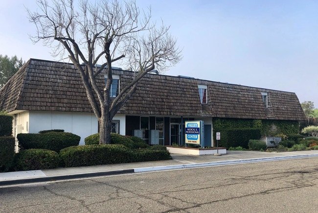
Property Record
2030 Viborg Rd, Solvang, CA 93463


Current Lease Availabilities
Property Detail
2030 Viborg Rd
Santa Maria-Santa Barbara, CA
TWP 06N RGE 31W SEC 15
139-530-004
Santa Barbara
Officebuilding
California
B and X Area of moderate flood hazard, usually the area between the limits of the 100-year and 500-year floods.
0.79 AC
2024
Central SB County
2025
Santa Barbara/Sta Maria/Goleta
001910
NEARBY LISTINGS FOR SALE OR LEASE
DEMOGRAPHICS near 2030 Viborg Rd
1 mile
3 mile
5 mile
2025 Total Population
3,368
10,946
17,208
2030 Population
3,271
10,551
16,515
Pop Growth 2025-2030
(2.88%)
(3.61%)
(4.03%)
Average Age
48
46
45
2025 Total Households
1,336
4,299
6,640
HH Growth 2025-2030
(3.07%)
(3.79%)
(4.19%)
Median Household Inc
$116,765
$118,005
$114,131
Avg Household Size
2.40
2.40
2.50
2025 Avg HH Vehicles
2.00
2.00
2.00
Median Home Value
$1,045,525
$1,070,613
$1,022,585
Median Year Built
1982
1979
1981
Nearby Places
Map Layers
Map Styles
 Street
 Aerial
Transit
 Traffic
 Biking
Places
Listings with unknown addresses are not visible on the map
- Restaurants
- Banks
- Shops
- Fitness
- Groceries
PUBLIC TRANSPORTATION
AIRPORT
Santa Barbara Municipal
Drive
Walk
Distance
Santa Barbara Municipal
64 min
40.3 mi
Freight Ports
The Port of Hueneme
Drive
Walk
Distance
The Port of Hueneme
100 min
72.7 mi
Nearby Properties
Address
Land Use
TOTAL SIZE
Lot Size
Zoning
Address
Land Use
TOTAL SIZE
Lot Size
Zoning
5.10 AC
Address
Land Use
TOTAL SIZE
Lot Size
Zoning
10.27 AC
Address
Land Use
TOTAL SIZE
Lot Size
Zoning
2.44 AC
Address
Land Use
TOTAL SIZE
Lot Size
Zoning
30.78 AC
Address
Land Use
TOTAL SIZE
Lot Size
Zoning
14,794 SF
34.82 AC
AGII40
Address
Land Use
TOTAL SIZE
Lot Size
Zoning
2.55 AC
Address
Land Use
TOTAL SIZE
Lot Size
Zoning
1.54 AC
Address
Land Use
TOTAL SIZE
Lot Size
Zoning
4.35 AC
C2
Address
Land Use
TOTAL SIZE
Lot Size
Zoning
8,775 SF
71.38 AC
AGII100
Address
Land Use
TOTAL SIZE
Lot Size
Zoning
0.04 AC
Address
Land Use
TOTAL SIZE
Lot Size
Zoning
52 AC
AGII40
Address
Land Use
TOTAL SIZE
Lot Size
Zoning
3.08 AC
Address
Land Use
TOTAL SIZE
Lot Size
Zoning
1.04 AC
Address
Land Use
TOTAL SIZE
Lot Size
Zoning
0.79 AC
Address
Land Use
TOTAL SIZE
Lot Size
Zoning
3.34 AC
Address
Land Use
TOTAL SIZE
Lot Size
Zoning
136.10 AC
AGII40
Address
Land Use
TOTAL SIZE
Lot Size
Zoning
0.35 AC
Address
Land Use
TOTAL SIZE
Lot Size
Zoning
1.73 AC
Address
Land Use
TOTAL SIZE
Lot Size
Zoning
15.19 AC
AGI10
Address
Land Use
TOTAL SIZE
Lot Size
Zoning
0.40 AC
Address
Land Use
TOTAL SIZE
Lot Size
Zoning
1.24 AC
Address
Land Use
TOTAL SIZE
Lot Size
Zoning
6,615 SF
49.67 AC
AGII100
Address
Land Use
TOTAL SIZE
Lot Size
Zoning
227.42 AC
AGII100
Address
Land Use
TOTAL SIZE
Lot Size
Zoning
0.91 AC
Address
Land Use
TOTAL SIZE
Lot Size
Zoning
0.86 AC
Address
Land Use
TOTAL SIZE
Lot Size
Zoning
2.62 AC
1E1
Address
Land Use
TOTAL SIZE
Lot Size
Zoning
0.46 AC
C2
Address
Land Use
TOTAL SIZE
Lot Size
Zoning
9,062 SF
0.52 AC
C2
The World's #1 Commercial Real Estate Marketplace
Connect with us
© 2026 CoStar Group
The information above has been obtained from sources believed reliable. While we do not doubt its accuracy we have not verified it and make no guarantee, warranty or representation about it. It is your responsibility to independently confirm its accuracy and completeness. Any projections, opinions, assumptions, or estimates used are for example only and do not represent the current or future performance of the property. The value of this transaction to you depends on tax and other factors which should be evaluated by your tax, financial, and legal advisors. You and your advisors should conduct a careful, independent investigation of the property to determine to your satisfaction the suitability of the property for your needs.