Property Record
20300 E 42Nd St S, Blue Springs, MO 64015

NEARBY LISTINGS FOR SALE OR LEASE
-
-
View all Blue Springs listings for sale on LoopNet.com
Property Detail
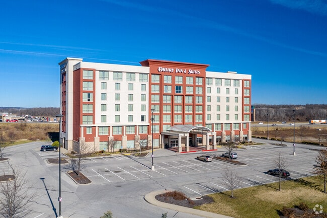
20300 E 42Nd St S
Kansas City, MO-KS
Trinity 2Nd Plat Lots 6-12
34-610-03-13-00-0-00-000
TRINITY 2ND PLAT LOTS 6-12 ---PT LOT 10 DAF: BEG NE COR SD L OT 10 TH S 03 DEG 25 MIN 54 SEC E 62 MOL TH S 85 DEG 52 MIN 07 SEC W 350 MOL TH N 35 DEG 06 MIN 02 SEC E 86 MOL TH N
Hotel
Jackson
X
Missouri
29095C0312G
10
2024
2.74 AC
2025
Kansas City Surrounding
014503
Kansas City
33,558 SF
DEMOGRAPHICS near 20300 E 42Nd St S
1 Mile
3 Mile
5 Mile
2024 Total Population
4,555
42,155
117,707
2029 Population
4,615
41,690
116,229
Pop Growth 2024-2029
+ 1.32%
(1.10%)
(1.26%)
Average Age
46
42
42
2024 Total Households
2,189
17,260
47,169
HH Growth 2024-2029
+ 1.60%
(1.12%)
(1.37%)
Median Household Inc
$53,619
$77,660
$73,620
Avg Household Size
1.90
2.40
2.40
2024 Avg HH Vehicles
1.00
2.00
2.00
Median Home Value
$153,899
$228,673
$216,240
Median Year Built
1996
1989
1980
Nearby Places
Map Layers
Map Styles
 Street
 Aerial
- Restaurants
- Banks
- Shops
- Fitness
- Groceries
PUBLIC TRANSPORTATION
COMMUTER RAIL
Independence Amtrak Station (Lincoln Service Missouri River Runner - Amtrak, Missouri River Runner - Amtrak)
DRIVE
WALK
Distance
Independence Amtrak Station (Lincoln Service Missouri River Runner - Amtrak, Missouri River Runner - Amtrak)
14 min
8.7 mi
AIRPORT
Kansas City International
DRIVE
WALK
Distance
Kansas City International
47 min
35.4 mi
Freight Ports
Tulsa Port Of Catoosa
DRIVE
WALK
Distance
Tulsa Port Of Catoosa
276 min
248.0 mi
Nearby Properties
Address
Land Use
TOTAL SIZE
Lot Size
Zoning
Address
Land Use
TOTAL SIZE
Lot Size
Zoning
398,212 SF
73.80 AC
Address
Land Use
TOTAL SIZE
Lot Size
Zoning
158,369 SF
47.47 AC
Address
Land Use
TOTAL SIZE
Lot Size
Zoning
100,724 SF
1.65 AC
Address
Land Use
TOTAL SIZE
Lot Size
Zoning
448,225 SF
38.38 AC
Address
Land Use
TOTAL SIZE
Lot Size
Zoning
385,487 SF
5.61 AC
Address
Land Use
TOTAL SIZE
Lot Size
Zoning
338,731 SF
29.59 AC
Address
Land Use
TOTAL SIZE
Lot Size
Zoning
171,513 SF
18.37 AC
Address
Land Use
TOTAL SIZE
Lot Size
Zoning
96,348 SF
14.42 AC
Address
Land Use
TOTAL SIZE
Lot Size
Zoning
94,411 SF
4.99 AC
Address
Land Use
TOTAL SIZE
Lot Size
Zoning
39,638 SF
Address
Land Use
TOTAL SIZE
Lot Size
Zoning
120,053 SF
13.53 AC
Address
Land Use
TOTAL SIZE
Lot Size
Zoning
179,962 SF
16.02 AC
Address
Land Use
TOTAL SIZE
Lot Size
Zoning
31,674 SF
11.45 AC
Address
Land Use
TOTAL SIZE
Lot Size
Zoning
287,132 SF
Address
Land Use
TOTAL SIZE
Lot Size
Zoning
286,547 SF
Address
Land Use
TOTAL SIZE
Lot Size
Zoning
61,901 SF
15.11 AC
Address
Land Use
TOTAL SIZE
Lot Size
Zoning
36,396 SF
8.64 AC
Address
Land Use
TOTAL SIZE
Lot Size
Zoning
75,028 SF
16.11 AC
Address
Land Use
TOTAL SIZE
Lot Size
Zoning
129,570 SF
18.40 AC
Address
Land Use
TOTAL SIZE
Lot Size
Zoning
67,820 SF
11.94 AC
Address
Land Use
TOTAL SIZE
Lot Size
Zoning
20.97 AC
Address
Land Use
TOTAL SIZE
Lot Size
Zoning
178,652 SF
15.07 AC
Address
Land Use
TOTAL SIZE
Lot Size
Zoning
113,696 SF
28.25 AC
Address
Land Use
TOTAL SIZE
Lot Size
Zoning
68,921 SF
18.04 AC
Address
Land Use
TOTAL SIZE
Lot Size
Zoning
48,440 SF
21.49 AC
Address
Land Use
TOTAL SIZE
Lot Size
Zoning
148,044 SF
17.85 AC
Address
Land Use
TOTAL SIZE
Lot Size
Zoning
56,664 SF
Address
Land Use
TOTAL SIZE
Lot Size
Zoning
137,992 SF
12.50 AC
Address
Land Use
TOTAL SIZE
Lot Size
Zoning
94,314 SF
20.02 AC
The World's #1 Commercial Real Estate Marketplace
Connect with us
© 2026 CoStar Group
The information above has been obtained from sources believed reliable. While we do not doubt its accuracy we have not verified it and make no guarantee, warranty or representation about it. It is your responsibility to independently confirm its accuracy and completeness. Any projections, opinions, assumptions, or estimates used are for example only and do not represent the current or future performance of the property. The value of this transaction to you depends on tax and other factors which should be evaluated by your tax, financial, and legal advisors. You and your advisors should conduct a careful, independent investigation of the property to determine to your satisfaction the suitability of the property for your needs.