Property Record
20302 Us Highway 18, Apple Valley, CA 92307


NEARBY LISTINGS FOR SALE OR LEASE
Property Detail
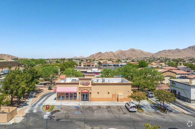
20302 Us Highway 18
3112-251-66
Parcel Map No. 17684
Restaurantdrivein
PARCEL MAP 17684 PARCEL 8 BOOK 229 PAGE 39 AMENDED PARCEL MAP 17684 REC BK 229 PGS 39-50 PMS PARCEL NO 8 AND INT IN COMMON AREA AS DESC BY #2008-0333028
X
San Bernardino
06071C5840H
California
2024
0.68 AC
2025
Mojave River Valley
009714
Inland Empire (California)
2,856 SF
Riverside-San Bernardino-Ontario, CA
DEMOGRAPHICS near 20302 Us Highway 18
1 Mile
3 Mile
5 Mile
2024 Total Population
5,791
43,505
94,170
2029 Population
5,877
44,133
96,394
Pop Growth 2024-2029
+ 1.49%
+ 1.44%
+ 2.36%
Average Age
35
38
38
2024 Total Households
1,848
14,057
31,574
HH Growth 2024-2029
+ 1.52%
+ 1.44%
+ 2.41%
Median Household Inc
$48,494
$75,523
$69,997
Avg Household Size
3.10
3.00
2.90
2024 Avg HH Vehicles
2.00
2.00
2.00
Median Home Value
$347,409
$374,238
$374,102
Median Year Built
1982
1984
1986
Nearby Places
Map Layers
Map Styles
 Street
 Aerial
- Restaurants
- Banks
- Shops
- Fitness
- Groceries
PUBLIC TRANSPORTATION
COMMUTER RAIL
DRIVE
WALK
Distance
8 min
4.9 mi
Nearby Properties
Address
Land Use
TOTAL SIZE
Lot Size
Zoning
Address
Land Use
TOTAL SIZE
Lot Size
Zoning
Address
Land Use
TOTAL SIZE
Lot Size
Zoning
172,153 SF
13.13 AC
Address
Land Use
TOTAL SIZE
Lot Size
Zoning
103,804 SF
14.32 AC
Address
Land Use
TOTAL SIZE
Lot Size
Zoning
57,365 SF
5.61 AC
Address
Land Use
TOTAL SIZE
Lot Size
Zoning
26,980 SF
2.50 AC
Address
Land Use
TOTAL SIZE
Lot Size
Zoning
75,280 SF
4.07 AC
Address
Land Use
TOTAL SIZE
Lot Size
Zoning
20,309 SF
2.35 AC
Address
Land Use
TOTAL SIZE
Lot Size
Zoning
Address
Land Use
TOTAL SIZE
Lot Size
Zoning
12,504 SF
2.97 AC
Address
Land Use
TOTAL SIZE
Lot Size
Zoning
42,078 SF
4.85 AC
AP
Address
Land Use
TOTAL SIZE
Lot Size
Zoning
29,042 SF
2.62 AC
Address
Land Use
TOTAL SIZE
Lot Size
Zoning
14,739 SF
1.38 AC
Address
Land Use
TOTAL SIZE
Lot Size
Zoning
49,851 SF
17.67 AC
Address
Land Use
TOTAL SIZE
Lot Size
Zoning
16,804 SF
1.80 AC
Address
Land Use
TOTAL SIZE
Lot Size
Zoning
5,394 SF
1.88 AC
Address
Land Use
TOTAL SIZE
Lot Size
Zoning
39,741 SF
3.68 AC
Address
Land Use
TOTAL SIZE
Lot Size
Zoning
22,488 SF
3.05 AC
Address
Land Use
TOTAL SIZE
Lot Size
Zoning
14,235 SF
1.15 AC
Address
Land Use
TOTAL SIZE
Lot Size
Zoning
2,618 SF
6.77 AC
Address
Land Use
TOTAL SIZE
Lot Size
Zoning
27,661 SF
2.36 AC
Address
Land Use
TOTAL SIZE
Lot Size
Zoning
138,827 SF
12.53 AC
Address
Land Use
TOTAL SIZE
Lot Size
Zoning
14,989 SF
1.42 AC
Address
Land Use
TOTAL SIZE
Lot Size
Zoning
19,328 SF
1.24 AC
Address
Land Use
TOTAL SIZE
Lot Size
Zoning
55,415 SF
2.91 AC
Address
Land Use
TOTAL SIZE
Lot Size
Zoning
28,929 SF
1.57 AC
Address
Land Use
TOTAL SIZE
Lot Size
Zoning
22,275 SF
2.27 AC
936
Address
Land Use
TOTAL SIZE
Lot Size
Zoning
3,500 SF
0.51 AC
Address
Land Use
TOTAL SIZE
Lot Size
Zoning
1.32 AC
936
Address
Land Use
TOTAL SIZE
Lot Size
Zoning
68,684 SF
1.55 AC
936
Address
Land Use
TOTAL SIZE
Lot Size
Zoning
64,784 SF
28.73 AC
The World's #1 Commercial Real Estate Marketplace
Connect with us
© 2025 CoStar Group
The information above has been obtained from sources believed reliable. While we do not doubt its accuracy we have not verified it and make no guarantee, warranty or representation about it. It is your responsibility to independently confirm its accuracy and completeness. Any projections, opinions, assumptions, or estimates used are for example only and do not represent the current or future performance of the property. The value of this transaction to you depends on tax and other factors which should be evaluated by your tax, financial, and legal advisors. You and your advisors should conduct a careful, independent investigation of the property to determine to your satisfaction the suitability of the property for your needs.