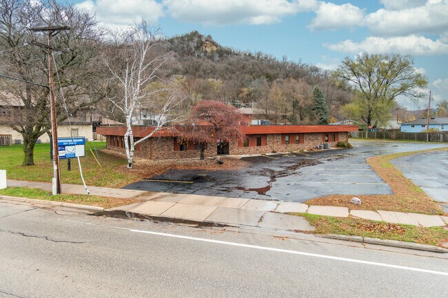
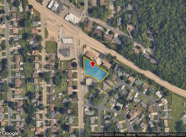
Property Record
2031 32Nd St S, La Crosse, WI 54601
Current Lease Availabilities
NEARBY LISTINGS FOR SALE OR LEASE
Property Detail
2031 32Nd St S
La Crosse-Onalaska, WI-MN
Gas Hut Addition
011-002433-000
GAS HUT ADDITION LOT 4
Commercialnec
La Crosse
X
Wisconsin
27055C0115E
4
2023
0.61 AC
2023
La Crosse/Onalaska
001200
Other Market Areas
DEMOGRAPHICS near 2031 32Nd St S
1 Mile
3 Mile
5 Mile
2024 Total Population
7,259
49,082
62,827
2029 Population
7,336
50,203
63,829
Pop Growth 2024-2029
+ 1.06%
+ 2.28%
+ 1.59%
Average Age
42
38
38
2024 Total Households
3,209
20,893
27,137
HH Growth 2024-2029
+ 0.81%
+ 2.47%
+ 1.66%
Median Household Inc
$65,449
$49,455
$49,665
Avg Household Size
2.20
2.10
2.10
2024 Avg HH Vehicles
2.00
2.00
2.00
Median Home Value
$180,485
$180,324
$178,851
Median Year Built
1962
1969
1969
Nearby Places
Map Layers
Map Styles
 Street
 Aerial
- Restaurants
- Banks
- Shops
- Fitness
- Groceries
PUBLIC TRANSPORTATION
COMMUTER RAIL
DRIVE
WALK
Distance
11 min
4.6 mi
AIRPORT
La Crosse Regional
DRIVE
WALK
Distance
La Crosse Regional
19 min
11.0 mi
Nearby Properties
Address
Land Use
TOTAL SIZE
Lot Size
Zoning
Address
Land Use
TOTAL SIZE
Lot Size
Zoning
4.65 AC
Address
Land Use
TOTAL SIZE
Lot Size
Zoning
38,407 SF
3.12 AC
MZA
Address
Land Use
TOTAL SIZE
Lot Size
Zoning
0.75 AC
MZA
Address
Land Use
TOTAL SIZE
Lot Size
Zoning
131,552 SF
0.89 AC
Address
Land Use
TOTAL SIZE
Lot Size
Zoning
3.91 AC
Address
Land Use
TOTAL SIZE
Lot Size
Zoning
73,056 SF
0.62 AC
Address
Land Use
TOTAL SIZE
Lot Size
Zoning
64,480 SF
0.69 AC
MZA
Address
Land Use
TOTAL SIZE
Lot Size
Zoning
0.12 AC
Address
Land Use
TOTAL SIZE
Lot Size
Zoning
11.56 AC
Address
Land Use
TOTAL SIZE
Lot Size
Zoning
54,884 SF
1.09 AC
MZA
Address
Land Use
TOTAL SIZE
Lot Size
Zoning
10.21 AC
MZA
Address
Land Use
TOTAL SIZE
Lot Size
Zoning
2.10 AC
MZA
Address
Land Use
TOTAL SIZE
Lot Size
Zoning
2.12 AC
MZA
Address
Land Use
TOTAL SIZE
Lot Size
Zoning
5.79 AC
MZA
Address
Land Use
TOTAL SIZE
Lot Size
Zoning
2.43 AC
Address
Land Use
TOTAL SIZE
Lot Size
Zoning
186,812 SF
15.04 AC
MZA
Address
Land Use
TOTAL SIZE
Lot Size
Zoning
0.56 AC
MZA
Address
Land Use
TOTAL SIZE
Lot Size
Zoning
27,000 SF
0.22 AC
MZA
Address
Land Use
TOTAL SIZE
Lot Size
Zoning
81,664 SF
1.06 AC
MZA
Address
Land Use
TOTAL SIZE
Lot Size
Zoning
32,153 SF
3.16 AC
MZA
Address
Land Use
TOTAL SIZE
Lot Size
Zoning
1.70 AC
MZA
Address
Land Use
TOTAL SIZE
Lot Size
Zoning
15.48 AC
MZA
Address
Land Use
TOTAL SIZE
Lot Size
Zoning
1.19 AC
Address
Land Use
TOTAL SIZE
Lot Size
Zoning
1.20 AC
MZA
Address
Land Use
TOTAL SIZE
Lot Size
Zoning
32.76 AC
MZA
Address
Land Use
TOTAL SIZE
Lot Size
Zoning
0.62 AC
Address
Land Use
TOTAL SIZE
Lot Size
Zoning
4.71 AC
Address
Land Use
TOTAL SIZE
Lot Size
Zoning
9,330 SF
1.42 AC
MZA
Address
Land Use
TOTAL SIZE
Lot Size
Zoning
5.01 AC
MZA
Address
Land Use
TOTAL SIZE
Lot Size
Zoning
3.04 AC
MZA
The World's #1 Commercial Real Estate Marketplace
Connect with us
© 2025 CoStar Group
The information above has been obtained from sources believed reliable. While we do not doubt its accuracy we have not verified it and make no guarantee, warranty or representation about it. It is your responsibility to independently confirm its accuracy and completeness. Any projections, opinions, assumptions, or estimates used are for example only and do not represent the current or future performance of the property. The value of this transaction to you depends on tax and other factors which should be evaluated by your tax, financial, and legal advisors. You and your advisors should conduct a careful, independent investigation of the property to determine to your satisfaction the suitability of the property for your needs.