Property Record
2031 Morewood Rd, Hardy, VA 24101
NEARBY LISTINGS FOR SALE OR LEASE
-
-
View all Hardy listings for sale on LoopNet.com
Property Detail
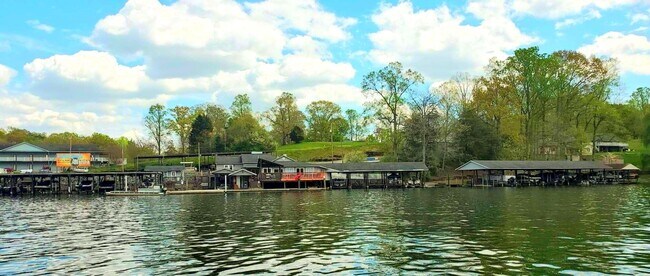
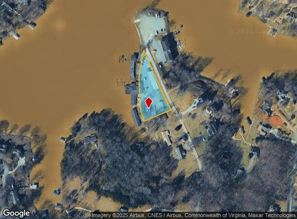
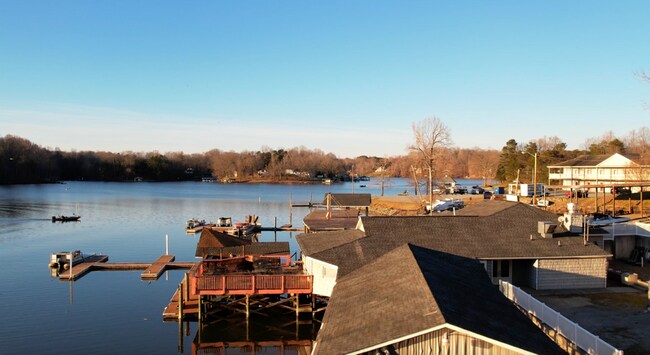
2031 Morewood Rd
0150001700
Bridgewater Pointe Condominium
Restaurantbuilding
RT 616 PT TRACT 2
X
Franklin
51019C0440D
Virginia
2025
1 AC
2025
North Franklin County
020302
Roanoke
3,588 SF
Roanoke, VA
DEMOGRAPHICS near 2031 Morewood Rd
1 Mile
3 Mile
5 Mile
2024 Total Population
843
4,927
11,709
2029 Population
888
5,225
12,405
Pop Growth 2024-2029
+ 5.34%
+ 6.05%
+ 5.94%
Average Age
52
50
49
2024 Total Households
381
2,166
5,120
HH Growth 2024-2029
+ 4.99%
+ 5.96%
+ 6.00%
Median Household Inc
$69,868
$78,604
$78,049
Avg Household Size
2.20
2.20
2.20
2024 Avg HH Vehicles
2.00
2.00
2.00
Median Home Value
$463,792
$390,565
$368,717
Median Year Built
1993
1991
1989
Nearby Places
Map Layers
Map Styles
 Street
 Aerial
- Restaurants
- Banks
- Shops
- Fitness
- Groceries
PUBLIC TRANSPORTATION
AIRPORT
Roanoke/Blacksburg Regional (Woodrum Field)
DRIVE
WALK
Distance
Roanoke/Blacksburg Regional (Woodrum Field)
51 min
29.7 mi
Freight Ports
Virginia Port Authority - Richmond
DRIVE
WALK
Distance
Virginia Port Authority - Richmond
217 min
156.2 mi
SALE & LEASE HISTORY
LISTING DATE
SALE/LEASE

Apr 01, 2022
For Sale
Nearby Properties
Address
Land Use
TOTAL SIZE
Lot Size
Zoning
Address
Land Use
TOTAL SIZE
Lot Size
Zoning
37,702 SF
3.90 AC
PCD
Address
Land Use
TOTAL SIZE
Lot Size
Zoning
22,488 SF
5.86 AC
PCD
Address
Land Use
TOTAL SIZE
Lot Size
Zoning
7,228 SF
8.50 AC
PCD
Address
Land Use
TOTAL SIZE
Lot Size
Zoning
40,454 SF
16.22 AC
SM
Address
Land Use
TOTAL SIZE
Lot Size
Zoning
69,458 SF
5.12 AC
PCD
Address
Land Use
TOTAL SIZE
Lot Size
Zoning
588.45 AC
SM
Address
Land Use
TOTAL SIZE
Lot Size
Zoning
27.71 AC
Address
Land Use
TOTAL SIZE
Lot Size
Zoning
29,863 SF
10.48 AC
PCD
Address
Land Use
TOTAL SIZE
Lot Size
Zoning
46,034 SF
5.99 AC
PCD
Address
Land Use
TOTAL SIZE
Lot Size
Zoning
41,054 SF
12.91 AC
B2
Address
Land Use
TOTAL SIZE
Lot Size
Zoning
18,044 SF
2.63 AC
PCD
Address
Land Use
TOTAL SIZE
Lot Size
Zoning
13.19 AC
Address
Land Use
TOTAL SIZE
Lot Size
Zoning
43,707 SF
4.37 AC
B2
Address
Land Use
TOTAL SIZE
Lot Size
Zoning
26,420 SF
13.83 AC
A1
Address
Land Use
TOTAL SIZE
Lot Size
Zoning
21,703 SF
6.34 AC
A1
Address
Land Use
TOTAL SIZE
Lot Size
Zoning
10,272 SF
19.60 AC
PCD
Address
Land Use
TOTAL SIZE
Lot Size
Zoning
110.43 AC
Address
Land Use
TOTAL SIZE
Lot Size
Zoning
15,000 SF
7.72 AC
B2
Address
Land Use
TOTAL SIZE
Lot Size
Zoning
6,648 SF
2.49 AC
Address
Land Use
TOTAL SIZE
Lot Size
Zoning
56.62 AC
PCD
Address
Land Use
TOTAL SIZE
Lot Size
Zoning
21,360 SF
3.76 AC
PCD
Address
Land Use
TOTAL SIZE
Lot Size
Zoning
45,064 SF
3.02 AC
PCD
Address
Land Use
TOTAL SIZE
Lot Size
Zoning
11,016 SF
1.73 AC
B2
Address
Land Use
TOTAL SIZE
Lot Size
Zoning
19,676 SF
4.01 AC
PCD
Address
Land Use
TOTAL SIZE
Lot Size
Zoning
2,690 SF
5.54 AC
Address
Land Use
TOTAL SIZE
Lot Size
Zoning
21,120 SF
1.55 AC
B2
Address
Land Use
TOTAL SIZE
Lot Size
Zoning
1,456 SF
4.44 AC
Address
Land Use
TOTAL SIZE
Lot Size
Zoning
57,250 SF
19.63 AC
B2
Address
Land Use
TOTAL SIZE
Lot Size
Zoning
19,102 SF
1.44 AC
B2
Address
Land Use
TOTAL SIZE
Lot Size
Zoning
8,860 SF
3.67 AC
B2
The World's #1 Commercial Real Estate Marketplace
Connect with us
© 2026 CoStar Group
The information above has been obtained from sources believed reliable. While we do not doubt its accuracy we have not verified it and make no guarantee, warranty or representation about it. It is your responsibility to independently confirm its accuracy and completeness. Any projections, opinions, assumptions, or estimates used are for example only and do not represent the current or future performance of the property. The value of this transaction to you depends on tax and other factors which should be evaluated by your tax, financial, and legal advisors. You and your advisors should conduct a careful, independent investigation of the property to determine to your satisfaction the suitability of the property for your needs.