Property Record
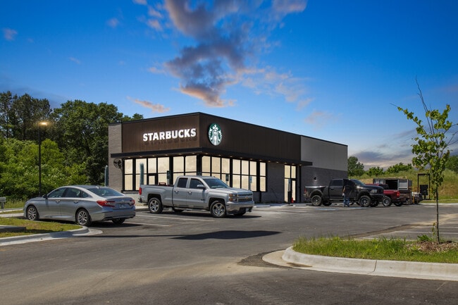
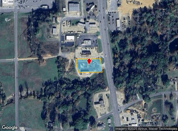
2031 Oliver Lancaster Blvd, Rockport, AR 72104
This Property Is For Sale
NEARBY LISTINGS FOR SALE OR LEASE
Property Detail
2031 Oliver Lancaster Blvd
810-01024-002
09-04S-17W Acreage (Outlots)
Restaurantdrivein
PT SE SE PT TRACT 2 PLAT ATTACHED CONTIG 810-01128-022
X
Hot Spring
05059C0225C
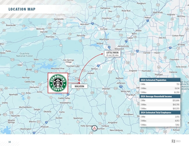
Arkansas
2025
0.93 AC
2025
Arkansas South Area
020200
Other Market Areas
2,568 SF
Malvern, AR
DEMOGRAPHICS near 2031 Oliver Lancaster Blvd
1 Mile
3 Mile
5 Mile
2024 Total Population
374
7,901
14,919
2029 Population
385
8,053
15,119
Pop Growth 2024-2029
+ 2.94%
+ 1.92%
+ 1.34%
Average Age
43
42
41
2024 Total Households
147
3,256
5,907
HH Growth 2024-2029
+ 3.40%
+ 2.00%
+ 1.41%
Median Household Inc
$38,571
$36,250
$42,706
Avg Household Size
2.30
2.30
2.40
2024 Avg HH Vehicles
2.00
2.00
2.00
Median Home Value
$97,958
$93,647
$97,327
Median Year Built
1977
1971
1973
Nearby Places
Map Layers
Map Styles
 Street
 Aerial
- Restaurants
- Banks
- Shops
- Fitness
- Groceries
PUBLIC TRANSPORTATION
COMMUTER RAIL
Malvern Amtrak (Texas Eagle - Amtrak)
DRIVE
WALK
Distance
Malvern Amtrak (Texas Eagle - Amtrak)
4 min
2.3 mi
Freight Ports
Port of Shreveport
DRIVE
WALK
Distance
Port of Shreveport
205 min
191.2 mi
Nearby Properties
Address
Land Use
TOTAL SIZE
Lot Size
Zoning
Address
Land Use
TOTAL SIZE
Lot Size
Zoning
159,013 SF
14.48 AC
Address
Land Use
TOTAL SIZE
Lot Size
Zoning
39,312 SF
2.19 AC
Address
Land Use
TOTAL SIZE
Lot Size
Zoning
18,360 SF
2.62 AC
Address
Land Use
TOTAL SIZE
Lot Size
Zoning
14,865 SF
5 AC
Address
Land Use
TOTAL SIZE
Lot Size
Zoning
44,701 SF
5.76 AC
Address
Land Use
TOTAL SIZE
Lot Size
Zoning
58,460 SF
9.03 AC
Address
Land Use
TOTAL SIZE
Lot Size
Zoning
66,368 SF
4.90 AC
Address
Land Use
TOTAL SIZE
Lot Size
Zoning
142,495 SF
7.56 AC
Address
Land Use
TOTAL SIZE
Lot Size
Zoning
38,652 SF
3.67 AC
Address
Land Use
TOTAL SIZE
Lot Size
Zoning
75,041 SF
7.27 AC
Address
Land Use
TOTAL SIZE
Lot Size
Zoning
36,026 SF
6.95 AC
Address
Land Use
TOTAL SIZE
Lot Size
Zoning
277,832 SF
12.29 AC
Address
Land Use
TOTAL SIZE
Lot Size
Zoning
25,290 SF
1.09 AC
Address
Land Use
TOTAL SIZE
Lot Size
Zoning
70,346 SF
8.29 AC
Address
Land Use
TOTAL SIZE
Lot Size
Zoning
25,804 SF
4 AC
Address
Land Use
TOTAL SIZE
Lot Size
Zoning
93,536 SF
32.17 AC
Address
Land Use
TOTAL SIZE
Lot Size
Zoning
27,642 SF
2.58 AC
Address
Land Use
TOTAL SIZE
Lot Size
Zoning
16,748 SF
3.54 AC
Address
Land Use
TOTAL SIZE
Lot Size
Zoning
7,396 SF
4 AC
Address
Land Use
TOTAL SIZE
Lot Size
Zoning
130,460 SF
17.31 AC
Address
Land Use
TOTAL SIZE
Lot Size
Zoning
17,750 SF
1.75 AC
Address
Land Use
TOTAL SIZE
Lot Size
Zoning
54,138 SF
1.49 AC
Address
Land Use
TOTAL SIZE
Lot Size
Zoning
65,668 SF
13.84 AC
Address
Land Use
TOTAL SIZE
Lot Size
Zoning
19,732 SF
1.43 AC
Address
Land Use
TOTAL SIZE
Lot Size
Zoning
14,466 SF
1.37 AC
Address
Land Use
TOTAL SIZE
Lot Size
Zoning
31,958 SF
2.60 AC
Address
Land Use
TOTAL SIZE
Lot Size
Zoning
6,768 SF
0.87 AC
Address
Land Use
TOTAL SIZE
Lot Size
Zoning
102,784 SF
24.45 AC
Address
Land Use
TOTAL SIZE
Lot Size
Zoning
26,193 SF
4.33 AC
Address
Land Use
TOTAL SIZE
Lot Size
Zoning
2,800 SF
3.06 AC
The World's #1 Commercial Real Estate Marketplace
Connect with us
© 2025 CoStar Group
The information above has been obtained from sources believed reliable. While we do not doubt its accuracy we have not verified it and make no guarantee, warranty or representation about it. It is your responsibility to independently confirm its accuracy and completeness. Any projections, opinions, assumptions, or estimates used are for example only and do not represent the current or future performance of the property. The value of this transaction to you depends on tax and other factors which should be evaluated by your tax, financial, and legal advisors. You and your advisors should conduct a careful, independent investigation of the property to determine to your satisfaction the suitability of the property for your needs.