Property Record
20310 290Th St, Poteau, OK 74953
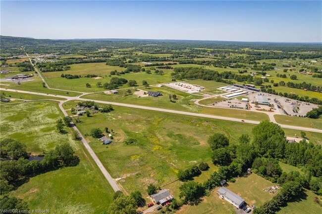
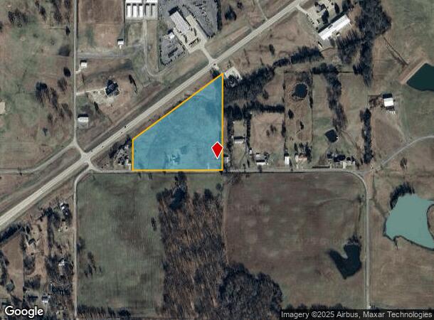
This Property Is For Sale
NEARBY LISTINGS FOR SALE OR LEASE
-
-
View all Poteau listings for sale on LoopNet.com
Property Detail
20310 290Th St
Fort Smith
Le Flore
Fort Smith, AR-OK
Oklahoma
0000-01-07N-25E-0-015-00
10.61 AC
Sfr
Le Flore County
1,256 SF
DEMOGRAPHICS near 20310 290Th St
1 Mile
3 Mile
5 Mile
2024 Total Population
450
6,734
13,026
2029 Population
461
6,882
13,422
Pop Growth 2024-2029
+ 2.44%
+ 2.20%
+ 3.04%
Average Age
38
39
39
2024 Total Households
179
2,667
4,905
HH Growth 2024-2029
+ 2.23%
+ 2.14%
+ 3.04%
Median Household Inc
$47,500
$52,123
$49,397
Avg Household Size
2.50
2.50
2.50
2024 Avg HH Vehicles
2.00
2.00
2.00
Median Home Value
$171,249
$171,167
$167,483
Median Year Built
1984
1982
1982
Nearby Places
- Restaurants
- Banks
- Shops
- Fitness
- Groceries
PUBLIC TRANSPORTATION
AIRPORT
Fort Smith Regional
DRIVE
WALK
Distance
Fort Smith Regional
44 min
26.3 mi
Freight Ports
Tulsa Port of Inola
DRIVE
WALK
Distance
Tulsa Port of Inola
140 min
112.4 mi
Nearby Properties
Address
Land Use
TOTAL SIZE
Lot Size
Zoning
Address
Land Use
TOTAL SIZE
Lot Size
Zoning
20,000 SF
19 AC
NP
Address
Land Use
TOTAL SIZE
Lot Size
Zoning
30,483 SF
12.68 AC
C2
Address
Land Use
TOTAL SIZE
Lot Size
Zoning
28,350 SF
0.39 AC
C2
Address
Land Use
TOTAL SIZE
Lot Size
Zoning
36,400 SF
3.81 AC
C2
Address
Land Use
TOTAL SIZE
Lot Size
Zoning
4,120 SF
85 AC
R1
Address
Land Use
TOTAL SIZE
Lot Size
Zoning
7,304 SF
6.37 AC
C1
Address
Land Use
TOTAL SIZE
Lot Size
Zoning
5,132 SF
1.14 AC
Address
Land Use
TOTAL SIZE
Lot Size
Zoning
14,438 SF
1.80 AC
C2
Address
Land Use
TOTAL SIZE
Lot Size
Zoning
6,967 SF
2.15 AC
Address
Land Use
TOTAL SIZE
Lot Size
Zoning
3,420 SF
1.86 AC
C2
Address
Land Use
TOTAL SIZE
Lot Size
Zoning
2,800 SF
6.63 AC
C2
Address
Land Use
TOTAL SIZE
Lot Size
Zoning
7,740 SF
2.58 AC
C2
Address
Land Use
TOTAL SIZE
Lot Size
Zoning
80 SF
4.89 AC
C1
Address
Land Use
TOTAL SIZE
Lot Size
Zoning
12,000 SF
1.59 AC
C2
Address
Land Use
TOTAL SIZE
Lot Size
Zoning
3,370 SF
2.79 AC
C2
Address
Land Use
TOTAL SIZE
Lot Size
Zoning
5,208 SF
0.92 AC
C1
Address
Land Use
TOTAL SIZE
Lot Size
Zoning
372 SF
5 AC
C1
Address
Land Use
TOTAL SIZE
Lot Size
Zoning
112 SF
1.64 AC
C2
Address
Land Use
TOTAL SIZE
Lot Size
Zoning
1,800 SF
6 AC
C2
Address
Land Use
TOTAL SIZE
Lot Size
Zoning
1,200 SF
3.59 AC
C2
Address
Land Use
TOTAL SIZE
Lot Size
Zoning
4,552 SF
0.74 AC
C2
The World's #1 Commercial Real Estate Marketplace
Connect with us
© 2025 CoStar Group
The information above has been obtained from sources believed reliable. While we do not doubt its accuracy we have not verified it and make no guarantee, warranty or representation about it. It is your responsibility to independently confirm its accuracy and completeness. Any projections, opinions, assumptions, or estimates used are for example only and do not represent the current or future performance of the property. The value of this transaction to you depends on tax and other factors which should be evaluated by your tax, financial, and legal advisors. You and your advisors should conduct a careful, independent investigation of the property to determine to your satisfaction the suitability of the property for your needs.