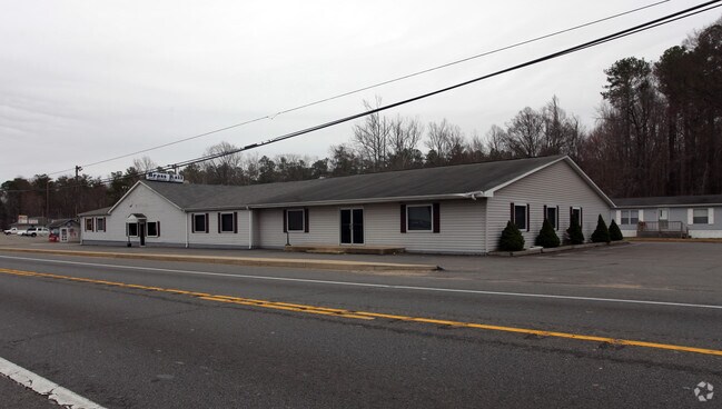
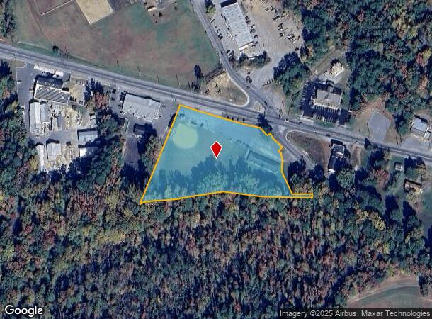
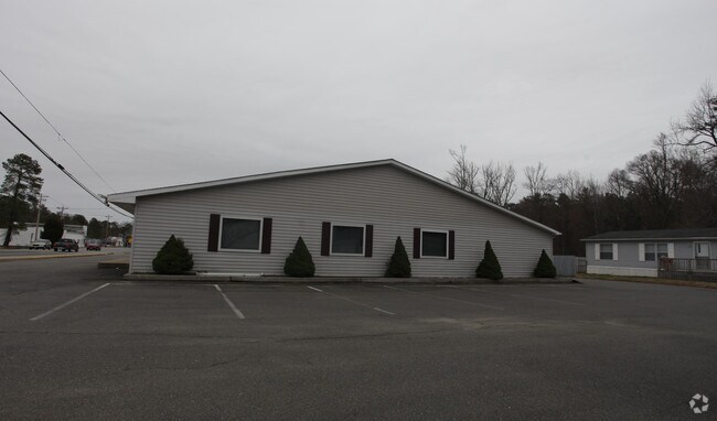
Property Record
20311 Point Lookout Rd, Great Mills, MD 20634
NEARBY LISTINGS FOR SALE OR LEASE
Property Detail
20311 Point Lookout Rd
02-014270
ADJUSTED PARCEL 95
Commercialnec
St Marys
AE
Maryland
24037C0307F
4.12 AC
2025
St Mary's County
2025
Washington, DC
876003
California-Lexington Park, MD
11,518 SF
DEMOGRAPHICS near 20311 Point Lookout Rd
1 Mile
3 Mile
5 Mile
2024 Total Population
2,456
20,835
45,815
2029 Population
2,515
21,375
47,547
Pop Growth 2024-2029
+ 2.40%
+ 2.59%
+ 3.78%
Average Age
36
36
36
2024 Total Households
879
8,022
17,777
HH Growth 2024-2029
+ 2.28%
+ 2.58%
+ 3.79%
Median Household Inc
$112,101
$89,501
$101,307
Avg Household Size
2.70
2.50
2.50
2024 Avg HH Vehicles
2.00
2.00
2.00
Median Home Value
$340,909
$286,518
$310,991
Median Year Built
1995
1992
1995
Nearby Places
Map Layers
Map Styles
 Street
 Aerial
- Restaurants
- Banks
- Shops
- Fitness
- Groceries
SALE & LEASE HISTORY
LISTING DATE
SALE/LEASE

Sep 24, 2016
For Sale
Jun 27, 2018
For Sale
Nearby Properties
Address
Land Use
TOTAL SIZE
Lot Size
Zoning
Address
Land Use
TOTAL SIZE
Lot Size
Zoning
149,880 SF
56.31 AC
RL
Address
Land Use
TOTAL SIZE
Lot Size
Zoning
24,477 SF
32.46 AC
RH
Address
Land Use
TOTAL SIZE
Lot Size
Zoning
28,962 SF
22.35 AC
RH
Address
Land Use
TOTAL SIZE
Lot Size
Zoning
139,728 SF
19.29 AC
RL
Address
Land Use
TOTAL SIZE
Lot Size
Zoning
53,410 SF
8.84 AC
RH
Address
Land Use
TOTAL SIZE
Lot Size
Zoning
208,563 SF
24.86 AC
RH
Address
Land Use
TOTAL SIZE
Lot Size
Zoning
29,394 SF
14.29 AC
RH
Address
Land Use
TOTAL SIZE
Lot Size
Zoning
1,200 SF
9.79 AC
OBP
Address
Land Use
TOTAL SIZE
Lot Size
Zoning
64,336 SF
33.17 AC
Address
Land Use
TOTAL SIZE
Lot Size
Zoning
57.72 AC
RH
Address
Land Use
TOTAL SIZE
Lot Size
Zoning
36,310 SF
5.98 AC
DMX
Address
Land Use
TOTAL SIZE
Lot Size
Zoning
48,128 SF
184.56 AC
RPD
Address
Land Use
TOTAL SIZE
Lot Size
Zoning
2,408 SF
36.09 AC
RH
Address
Land Use
TOTAL SIZE
Lot Size
Zoning
57,040 SF
2.68 AC
RL
Address
Land Use
TOTAL SIZE
Lot Size
Zoning
130,092 SF
7.14 AC
RH
Address
Land Use
TOTAL SIZE
Lot Size
Zoning
17,234 SF
14.57 AC
RH
Address
Land Use
TOTAL SIZE
Lot Size
Zoning
9,000 SF
4.02 AC
CMX
Address
Land Use
TOTAL SIZE
Lot Size
Zoning
29,902 SF
6.64 AC
RL
Address
Land Use
TOTAL SIZE
Lot Size
Zoning
25.29 AC
RH
Address
Land Use
TOTAL SIZE
Lot Size
Zoning
46,200 SF
3.66 AC
RMX
Address
Land Use
TOTAL SIZE
Lot Size
Zoning
7,680 SF
8.13 AC
RH
Address
Land Use
TOTAL SIZE
Lot Size
Zoning
20,170 SF
9.96 AC
RPD
Address
Land Use
TOTAL SIZE
Lot Size
Zoning
5,624 SF
16.74 AC
DMXC
Address
Land Use
TOTAL SIZE
Lot Size
Zoning
61,534 SF
44.65 AC
RL
Address
Land Use
TOTAL SIZE
Lot Size
Zoning
40,000 SF
6.25 AC
DMX
Address
Land Use
TOTAL SIZE
Lot Size
Zoning
12,600 SF
5.75 AC
OBP
Address
Land Use
TOTAL SIZE
Lot Size
Zoning
28,136 SF
2.24 AC
DMX
Address
Land Use
TOTAL SIZE
Lot Size
Zoning
12,672 SF
4.60 AC
DMX
Address
Land Use
TOTAL SIZE
Lot Size
Zoning
58,114 SF
10.04 AC
RMX
Address
Land Use
TOTAL SIZE
Lot Size
Zoning
25,272 SF
1.97 AC
OBP
The World's #1 Commercial Real Estate Marketplace
Connect with us
© 2025 CoStar Group
The information above has been obtained from sources believed reliable. While we do not doubt its accuracy we have not verified it and make no guarantee, warranty or representation about it. It is your responsibility to independently confirm its accuracy and completeness. Any projections, opinions, assumptions, or estimates used are for example only and do not represent the current or future performance of the property. The value of this transaction to you depends on tax and other factors which should be evaluated by your tax, financial, and legal advisors. You and your advisors should conduct a careful, independent investigation of the property to determine to your satisfaction the suitability of the property for your needs.